Monday May 21, 2012
Last year was classified as having the worst storms ever recorded in history of the United States. In 2011, La Niña disappeared in early January and was not replaced by El Niño, resulting in an untamed jet stream that wreaked havoc on the United States. The spring was plagued with severe storms, tornadoes, hail and lightening that killed hundreds of people.
Climatological conditions known as El Niño and La Niña develop when abnormally warm or cool sea surface temperatures (SST) in the eastern Pacific interact with the atmosphere. An El Niño occurs when the SST rise above normal (3 month average >0.5 Celsius) following months of faltering trade winds. The warm ocean surface water adds moisture to the air above it, forming low-pressure systems. A La Niña occurs when the trade winds push the warmer surface waters away from the equator. The warm water is replaced by cooler, nutrient-rich water rising from deeper in the ocean, a process called upwelling. The cooler water impedes the formation of rain-producing clouds, leading to dry conditions near the equator in the Pacific Ocean. These two phenomena provide structure to the climate system for the entire winter allowing climatologists to make fairly decent long range forecast.
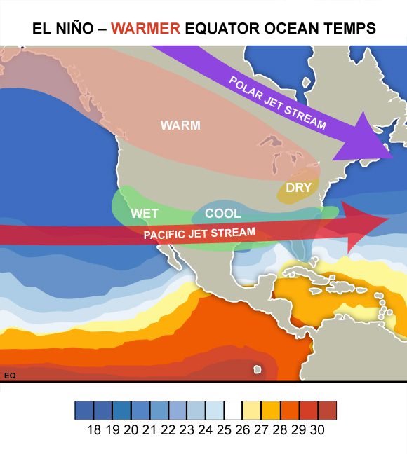
Figure 1. Sea surface temperatures (°C) and climate conditions during an El Niño.
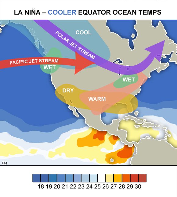
During an El Niño, weather conditions between October and March tend to be wetter than normal in the southern United States. The opposite is observed in the northern United States, with drier winters resulting in reduced rain and snowfall (Figure 1). The climatic effect of a La Niña in these regions is almost the opposite compared to El Niño. The southern region experiences drier than normal conditions while the northern region experiences wetter than normal conditions (Figure 2).
Although El Niño generally brings more rainfall to the southern region, there are some exceptions. La Niña appears to be the more reliable of the two, almost always bringing dry conditions to the southern region. Climate effects in the northern region, on the other hand, are not as reliable and harder to predict. While La Niña generally brings wetter conditions, the effects of El Niño appear to be less predictable in this region.
Figure 2. Sea surface temperatures (°C) and climate conditions during an La Niña.
The ocean-atmosphere interaction, known as the El Niño-Southern Oscillation (ENSO), affects the location of the jet stream, altering rainfall patterns across the United States and throughout the tropics. The shifting of the jet stream alters the location and frequency of severe storms and hurricanes in the Atlantic and Pacific Oceans. La Niña tends to lead to wind patterns that favor the formation of hurricanes in the Atlantic while reducing the number in the Pacific. Whereas, El Niño tends to reduce the number of hurricanes in the Atlantic, but increase the number of hurricanes in the eastern Pacific.
La Niña pushes the jet stream northward, forcing cold Arctic air away from the lower United States, while El Niño pushes the jet stream south bringing more storms with it. In the absence of a La Niña or El Niño (i.e., ENSO-neutral), the jet stream is unconstrained resulting in an unpredictable weather pattern as the jet stream is allowed to meander wildly through the United States. In 2012, La Niña dissipated last month and has not been replaced by an El Niño. Climate models indicate it is unlikely that the La Niña will re-develop later in the summer, but there is uncertainty as to whether ENSO-neutral or El Niño conditions will prevail. We could be in for another crazy year of weather if the jet stream is left untamed.


