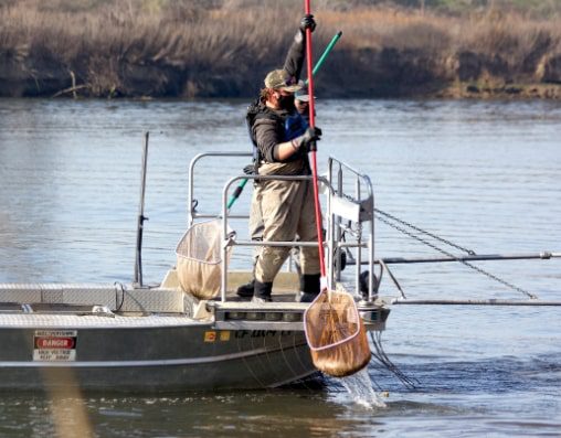
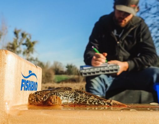
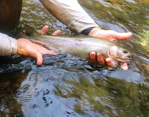
Fisheries Research, Monitoring, and Conservation

  • Home
  • Services
  • News
  • Blog
  • Fablab
  • About
  • Jobs
  • Contact Us

Services

Fish Population Dynamics Fish Population Evaluation Fish Movement & Behavior Fish Habitat Environmental Permitting & Compliance Specialized Equipment Fabrication Communication & Collaboration International Fisheries Threatened & Endangered Species Habitat Restoration

Fish Population Dynamics

We study the key role fish populations play in supporting fisheries and ecosystem processes. Our work includes fish life history and limiting factor analyses, predator-prey interactions and aquatic food web studies, and monitoring fisheries harvest and management trends.
Fish Population Dynamics

Featured Projects

Electrofishing cataraft.jpg

Stanislaus Native Fish Plan

The Native Fish Plan is a large collaborative project to improve the conditions of - Read More…
Fish Population Dynamics
Featured Project
June 18, 2019

Stanislaus Native Fish Plan

Electrofishing cataraft.jpg

The Native Fish Plan is a large collaborative project to improve the conditions of the Stanislaus River to support thriving populations of native fishes, such as salmon and trout. The project is studying the impact of non-native predatory fishes on native salmon, as well as potential solutions for improving salmon survival, such as removing predators from specific stretches of the salmon migration route. Results of the project can be used to design management actions that will benefit native fishes on the Stanislaus River.

Since 2017, FISHBIO has collaborated with the California Department of Wildlife and NOAA Fisheries to design, permit, and implement the study, including conducting electrofishing surveys to collect baseline information on the abundance, distribution, and composition of native and non-native fish predator populations in the lower Stanislaus River. Stomach and scale samples are being collected from key predatory fish species to evaluate their diet composition and age composition to help assess the relative risk of each predatory species to juvenile Chinook salmon. Prior to release, fish are tagged with a Passive Integrated Transponder (PIT) tag to identify the same fish if it is recaptured and assess its movement and survival.

OLYMPUS DIGITAL CAMERAAnother aspect of the study is to scientifically evaluate the effect of removing non-native fish to reduce predation pressure on juvenile salmon. Non-native fish are removed using electrofishing, and predation is measured using devices called Predation Event Recorders, or PERs. Each PERs unit is outfitted with a GPS-enabled locator, temperature and light sensor, event logger, and GoPro camera, and is tethered to a hatchery-origin Chinook salmon smolt. The PERs are released in the river to drift downstream, and if the salmon smolt is eaten, the device will record the time, location, and footage of the predatory species. These devices are used to compare the relative rates of predation between river reaches where predators have been removed versus reaches where no predators were removed. Removed fish are relocated from the study area.

The Native Fish Plan is authorized by the Water Infrastructure Improvements for the Nation Act (passed by Congress in December 2016), which requires the Oakdale and South San Joaquin Irrigation Districts to work with the National Marine Fisheries Service (NOAA Fisheries) to jointly establish a five-year pilot program in the Stanislaus River to investigate the effectiveness of removing predatory fishes to improve salmon survival. The results of the study can be found online here.

View project photos.

DCIM149GOPRO
Back to Services
Testing Predation Tag

Testing the Predator Detection Acoustic Tag

How can we tell whether an acoustically tagged fish has been eaten by a - Read More…
Fish Population Dynamics
Featured Project
January 24, 2017

Testing the Predator Detection Acoustic Tag

Testing Predation Tag

How can we tell whether an acoustically tagged fish has been eaten by a predator? To answer this question of great importance for aquatic research studies, Hydroacoustic Technology, Inc. (HTI) developed a new technology. Patented in 2015, the Predation Detection Acoustic Tag (PDAT) is designed to detect predation events with the help of a unique digestible fuse. Stomach enzymes of the predatory fish break down the fuse, resulting in an open circuit that alters the signal of the tag to relay that the tagged fish has been eaten.

Predation Detection Acoustic TagFISHBIO and HTI are collaborating to conduct tests of the PDAT in our Fish Lab. The objectives of this testing are to evaluate the effectiveness of the tag, and record how long it takes for the tag to detect a predation event. As part of the testing, juvenile rainbow trout are surgically implanted with the PDAT. Tagged fish are then fed to largemouth bass and continuously monitored for activation of the predation tag signal. The test allows us to compare the performance of the tag among different individual predators, and lays the groundwork for testing the tag in the field.

Back to Services
Tuolumne Floodplain seining

Tuolumne River Research and Monitoring Program

Since 1998, FISHBIO personnel have managed the Tuolumne River Research and Monitoring Program for - Read More…
Fish Population Dynamics
Featured Project
August 21, 2015

Tuolumne River Research and Monitoring Program

Tuolumne Floodplain seining

Since 1998, FISHBIO personnel have managed the Tuolumne River Research and Monitoring Program for the Turlock Irrigation District, the Modesto Irrigation District, and the City and County of San Francisco. The program’s suite of ongoing monitoring activities tracks the abundance, distribution, migration characteristics, and habitat use of salmon and steelhead trout. Rotary screw trap monitoring helps estimate abundance and migration characteristics of juvenile salmonids and other fishes, and evaluate reach survival relative to environmental conditions. Complementary monitoring with a fish counting weir equipped with a Vaki Riverwatcher infrared system documents upstream migration and population abundance of adult salmonids and other fishes.

Rotary screw trap monitoring

Other regular program activities include snorkel and seining surveys to document fish abundance and habitat use, redd surveys to document salmon spawning, habitat surveys, and water quality monitoring. FISHBIO has also conducted FERC relicensing studies on telemetry and diet to assess fish survival and predation. The success of these projects has depended on our team members establishing trusted relationships with landowners to access private property, and working in close coordination with various state, federal, and private agencies to expeditiously obtain numerous research permits for salmon and steelhead.


Back to Services
Stanislaus River snorkel survey

Stanislaus River Research and Monitoring Program

The Stanislaus River Research and Monitoring Program is the most comprehensive and longest running - Read More…
Fish Population Dynamics
Featured Project
August 27, 2014

Stanislaus River Research and Monitoring Program

Stanislaus River snorkel surveyThe Stanislaus River Research and Monitoring Program is the most comprehensive and longest running salmon and steelhead monitoring program in California’s San Joaquin Basin. Initiated by FISHBIO personnel in 1993 for the Oakdale and South San Joaquin Irrigation Districts and Tri-Dam Project, the program’s suite of ongoing monitoring activities tracks the abundance, distribution, migration characteristics, and habitat use of salmon and steelhead trout. The project also seeks to determine the effects of reservoir operations and the highly altered channel geometry (which has experienced gravel extraction, levee construction, and woody debris removal) on the fish and wildlife populations in the Lower Stanislaus River.

Stanislaus river rotary screw trapFISHBIO has designed and continues to implement multiple study elements, including snorkel, seining, electrofishing, and DIDSON surveys; radio and acoustic tracking of salmon and predatory species; an adult fish counting weir with an infrared monitoring system (Vaki Riverwatcher); redd surveys; and rotary screw trap monitoring. We have also conducted meso- and microhabitat mapping and modeling (which includes flow velocities, bathymetry and discharge), and monitor water quality parameters such as water temperature, dissolved oxygen, turbidity, and conductivity. FISHBIO personnel are currently investigating how fish respond to flow regimes and physical habitat features at five study reaches on the Stanislaus River to inform water resources best management practices to improve fish habitat and fish populations. The success of these projects has depended on our team members establishing trusted relationships with landowners to access private property, and working in close coordination with various state, federal, and private agencies to expeditiously obtain numerous research permits for salmon and steelhead.

Publications:

Pilger, T., M. Peterson, D. Lee, A. Fuller, and D. Demko. 2019. Evaluation of long-term mark-recapture data for estimating abundance of juvenile fall-run Chinook salmon on the Stanislaus River from 1996 to 2017. San Francisco Estuary and Watershed Science 17. DOI: 10.15447/sfews.2019v17iss1art4

Peterson, M.L., A.N. Fuller, and D. Demko. 2017. Environmental factors associated with the upstream migratory activity of fall-run Chinook salmon in a regulated river. North American Journal of Fisheries Management 37: 78-93. DOI: 10.1080/02755947.2016.1240120

Back to Services
See more featured projects
OLYMPUS DIGITAL CAMERA

San Joaquin River Predator Population Study

The fish assemblages in the San Joaquin River and the Sacramento-San Joaquin Delta are - Read More…
Fish Population Evaluation
Featured Project
May 24, 2019

San Joaquin River Predator Population Study

OLYMPUS DIGITAL CAMERA

The fish assemblages in the San Joaquin River and the Sacramento-San Joaquin Delta are heavily dominated by non-native species. However, the population sizes of many of these species are unknown. To help fill in this information gap, FISHBIO is conducting a study to count five species of bass and catfish in the San Joaquin River to help estimate their population sizes. These species are known to eat juvenile salmon and trout, and better estimates of their abundance will help assess the risk of predation to young salmonids in the San Joaquin River, as well as whether this risk may be limiting salmon and steelhead recovery in the region.

The objective of this study is to use a mark-and-recapture method to estimate the population sizes of striped bass, largemouth bass, smallmouth bass, white catfish, and channel catfish. To catch these fishes, five large fyke traps are deployed over 63 km of the lower San Joaquin River. A fyke trap has a funnel-shaped opening that narrows toward the interior of the trap. Migrating fish that swim into the funnel are trapped in the compartment at the back of the fyke. The California Department of Fish and Wildlife has been using these fyke traps to sample striped bass in the Sacramento River basin since 1951, but a similar effort has not yet been carried out in the San Joaquin River. This study builds on a pilot effort FISHBIO conducted in 2013 to examine the feasibility of fyke traps to capture striped bass.

Individuals of the five target species that are caught in the fyke traps are tagged with Passive Integrated Transponder (PIT) tags, as well as pink external tags (either long spaghetti tags or round disc tags), which may be turned in for a reward if recaptured. Stomach samples are also collected to help examine the similarities and differences between the diets of the different species. So far, anglers have reported catching marked fishes up to 230 miles away from where they were tagged (see map below). This project is funded by the Banta Carbona, Patterson, and West Stanislaus Irrigation Districts, and will help illuminate the movements and relative abundance of several non-native species, as well as how their population dynamics may impact the survival of native salmonids in the San Joaquin River Basin.

Map of Fyke project tag recaptures

How Many Bass and Catfish are in the San Joaquin River?

One fish, two fish – Using mark-recapture to estimate population size

Improving our Odds


Back to Services
Calaveras Kayak

Calaveras River Monitoring Program

The Calaveras River is an unusual tributary to the San Joaquin River in California’s - Read More…
Fish Population Evaluation
Featured Project
September 21, 2017

Calaveras River Monitoring Program

Calaveras Kayak

The Calaveras River is an unusual tributary to the San Joaquin River in California’s Central Valley, being fed mostly by rain rather than melting snow. This creates a flashy system similar to a coastal stream. Historically, the Calaveras would flood in the winter and dry up in the summer, with some sections going completely dry and creating disconnected pools. The construction of reservoirs has changed the patterns of the river by maintaining a more consistent flow of water year-round, which has allowed fish like rainbow trout/steelhead (Oncorhynchus mykiss) to persist where historically they would have occurred only sporadically.

Since 2001, FISHBIO has conducted a long-term monitoring program for O. mykiss on the Calaveras River. Program activities include rotary screw traps, snorkel surveys, benthic macroinvertebrate sampling, redd surveys, temperature monitoring, and fyke netting. FISHBIO staff regularly tag captured O. mykiss with surgically implanted 23-mm PIT tags to study life-history variation in this species. FISHBIO is also working to develop a Habitat Conservation Plan for the Calaveras River that provides measures to address potential effects of Stockton East Water District and Calaveras County Water District operations on salmonids, and lists conservation measures to minimize and mitigate for any identified impacts.

Back to Services
fyke trap

Striped Bass Fyke Trap Pilot Study

While considerable research on striped bass in California has focused on their population in - Read More…
Fish Population Evaluation
Featured Project
August 22, 2014

Striped Bass Fyke Trap Pilot Study

fyke trapWhile considerable research on striped bass in California has focused on their population in the Sacramento River, less is known about how and when these predators use the San Joaquin River and its tributaries as habitat. After noticing striped bass passing through the Stanislaus River weir in the spring, FISHBIO decided to conduct a feasibility study to test whether fyke traps could be used to estimate the population of striped bass in the San Joaquin River during the spring, similar to fyke trap surveys conducted by the Department of Fish and Wildlife (DFW) in the Sacramento River. The goals of the study were to evaluate trap catch rates and trap deployment locations.

FISHBIO fabrication experts constructed two 10-foot-diameter fyke traps, similar in design to the traps DFW has used in the Sacramento River for decades. We fished the traps for 24-hour periods over the course of three weeks, and checked them each morning. In addition to striped bass, the traps caught American shad, largemouth bass, white catfish, and suckers. All healthy striped bass of legal size were tagged with PIT tags and external disc tags. The PIT tags will last the life of the fish, and in the future, it could be possible to monitor individual striped bass moving into the river’s tributaries using PIT tag antennas attached to weirs throughout the basin.

tagged striped bassThe results of this pilot study demonstrate the successful use of fyke traps to capture and release healthy striped bass in the mainstem of the San Joaquin River. Anglers have reported re-capturing at least four tagged fish (9% of the fish that were tagged); however, no tagged fish were recaptured in fyke traps during the pilot. Therefore, increased effort would be needed (either in the form of more traps or a longer sampling period) to conduct a successful mark-recapture study. The mark-recapture of striped bass would not only be useful for counting individual fish in the San Joaquin Basin, but the sampling could also provide a platform for other valuable research on striped bass movements, such as using PIT and acoustic telemetry technologies. Telemetry studies conducted on striped bass in their native East Coast habitat indicate distinct subpopulations vary considerably in their seasonal migration patterns, ranging from “resident” to “migratory/anadromous,” and also show seasonal site fidelity. A final report on the pilot study findings is available to download here.

Download Study Final Report
See Project Photos

Back to Services

Big Chico Creek Fish Population Surveys

Big Chico Creek is a northern Central Valley stream that supports populations of both - Read More…
Fish Population Evaluation
Featured Project
July 15, 2014

Big Chico Creek Fish Population Surveys

snorkeling in Big Chico CreekBig Chico Creek is a northern Central Valley stream that supports populations of both steelhead and resident rainbow trout. In August 2013, FISHBIO completed the first survey of the Big Chico Creek watershed in more than a decade to catalogue the abundance of trout and other fishes. We surveyed the entire 4.5-mile reach of the creek within the boundaries of the Big Chico Creek Ecological Reserve (BCCER, a 4,000-acre tract of land owned and managed by the CSU Chico Research Foundation) on foot, and mapped and categorized the creek habitat. We also conducted snorkel surveys to observe fish, and estimated more than 2,500 rainbow trout/steelhead (Oncorhynchus mykiss) to inhabit the creek within the reserve boundaries, in addition to nearly 200 (nonnative) brown trout (Salmo trutta). Other native fishes observed include Sacramento suckers, riffle sculpin, and California roach. However, Sacramento pikeminnow and hardhead, two large, native cyprinid species, were conspicuously absent from the creek – perhaps a lingering effect of a rotenone treatment by the California Department of Fish and Wildlife nearly 30 years ago.

Trends in the abundance and size structure of these species can be documented through continued monitoring of Big Chico Creek. This is possibly the only recent study that attempts to quantify actual summertime abundance of rainbow trout in an eastside tributary of the Sacramento River. The relatively high density of O. mykiss estimated in this study, and the observation of an adult steelhead, are a testament to the importance of Big Chico Creek and the BCCER to the conservation and recovery of Central Valley steelhead. FISHBIO repeated this survey in 2014 and 2019. Final reports of the fish population surveys can be downloaded below.

Download the BCCER Fish Population Survey Report 2019

Download the BCCER Fish Population Survey Report 2014

Download the BCCER Fish Population Survey Report 2013


Back to Services
See more featured projects
Smolt spy fisheries monitoring camera system

The Smolt Spy

The Smolt Spy is FISHBIO’s first fully custom video monitoring system that can be - Read More…
Fish Movement & Behavior
Featured Project
May 04, 2018

The Smolt Spy

Smolt spy fisheries monitoring camera system

The Smolt Spy is FISHBIO’s first fully custom video monitoring system that can be configured for a variety of applications to monitor juvenile and adult fish. The system consists of high-definition Internet Protocol (IP) digital cameras that are operated with a computer and software, and have much higher resolution than the closed-circuit television (CCTV) security cameras that are often used for monitoring. The cameras use wide-angle lenses to help eliminate blind spots, and are paired with infrared lights that minimize disturbance to fish. The biggest advantage of the Smolt Spy system is the incorporation of motion-detection software, which records video of passing fish as small as 50 mm and greatly reduces the amount of video to review. Digital videos are sent from the cameras to a connected computer and can be saved to portable hard drives, which allows the system to operate largely unattended. Hard drives are periodically replaced and the videos can be reviewed by a trained fisheries technician to quickly identify and count passing fish.

The original Smolt Spy prototype was designed and built for the Summit Lake Paiute Tribe in Nevada to monitor juvenile Lahontan cutthroat trout in Mahogany Creek. Since then, we have developed several variations of this system to monitor both juvenile and adult fish, including installing a system with a fish-counting weir to count adult Chinook salmon moving upstream and downstream in the Tuolumne River. This setup used an overhead camera to count fish moving through a square passageway, and two underwater side cameras to identify fish species and physical attributes. We have custom-fabricated a video monitoring system with four cameras encased in fiberglass housings to fit within an existing fish ladder on the Calaveras River, and have also built a Smolt Spy to monitor juvenile steelhead moving into a surface fish collector at Los Padres Reservoir on the Carmel River. The Smolt Spy system provides an effective means to passively count small and large fish, and eliminates the need to trap and handle sensitive species. Contact us to find out if this technology is a good fit for your project!

Assembling smolt spy video caemera
Back to Services
Los Padres Reservoirs

Steelhead Migration Monitoring at Los Padres Reservoir

In 2017, FISHBIO began providing services to California American Water to help monitor the - Read More…
Fish Movement & Behavior
Featured Project
February 02, 2018

Steelhead Migration Monitoring at Los Padres Reservoir

Los Padres Reservoirs

In 2017, FISHBIO began providing services to California American Water to help monitor the steelhead at Los Padres Reservoir on the Carmel River. We evaluated a recently installed behavioral guidance system and floating surface collector that are intended to assist the downstream migration of coastal steelhead. The fish guidance system, positioned in front of the Los Padres Reservoir spillway, consists of a string of buoys with curtains suspend below. This device directs fish into a floating surface collector, which sends them into a pipeline leading from the top of the dam down to the Carmel River below. FISHBIO designed and installed a Smolt Spy video monitoring system within the surface collector to identify and enumerate fish moving through this system. We have also provided support with maintenance and adjustments of the guidance system and debris management buoys.

Cleaning debris at Los Padres Reservoir
Back to Services
Fish ladder video camera system

Automated Fish Ladder Camera

Fish ladders can be perfect places for installing fish counting stations because they are - Read More…
Fish Movement & Behavior
Featured Project
July 25, 2017

Automated Fish Ladder Camera

Fish ladder video camera system

Fish ladders can be perfect places for installing fish counting stations because they are often narrow enough that only a few fish can pass through a given point at once, making it easier to count fish automatically. However, FISHBIO discovered that ladder-ready automated fish counters are not easily available, so we decided to build one ourselves. Our fabrication team started with our Smolt Spy camera concept, then added multiple cameras and infrared lighting in a U-shaped housing to integrate seamlessly into a diversion weir fish ladder on the Calaveras River. The system slides right into the ladder almost like another “rung,” and provides optimal underwater viewing without the threat of being destroyed by debris or high flows.

Fabricating fish ladder camera housing

The key to this new system is the small size of the cameras and their custom protective housings, which allow them to be installed in the baffles of a fish ladder. Each side of the ladder is equipped with two high-definition video cameras and an infrared light embedded into a baffle, which enables video recording even in complete darkness. Multiple cameras allow monitoring to occur under both high- and low-flow conditions, and provide redundancy in case of failure. Since fish often migrate during times of high turbidity, which decreases visibility, we installed cameras on both sides of the ladder to reduce the distance each camera needs to see through. The high-definition, wide-angle, internet protocol (IP) cameras are each encased in a custom fiberglass housing, ensuring they are completely waterproof. The IP cameras are higher resolution than typical closed-circuit security cameras, which helps provide quality images in turbid and low-light conditions.

Installing fish ladder camera system

When darkness falls, a photovoltaic sensor triggers the cameras to switch to black-and-white recording, which utilizes infrared light. The infrared lights use very little power, but provide just enough light for the camera to capture quality images in the dark. These lights are not visible to the eyes of humans or fish, so there is no concern of drawing the attention of vandals or of affecting the migration of fish through the ladder. The low power consumption of the entire system allows it to be operated on solar power, which is important because many ladders are built in remote locations.

Fish ladder with cameras exposed

We incorporated motion-detection software into this camera system to significantly reduce the amount of time required to review recorded video footage to identify fish passages. The software includes the ability to tailor the motion detection sensitivity to adjust to changing conditions as needed. In addition to providing short clips of fish passages, the system can also simultaneously produce a continuous, 24-7 video recording, which serves as a backup. This system completely custom-built system has been successfully operated to collect video of migrating trout and salmon.

Back to Services
Tuolumne Floodplain seining

Tuolumne River Research and Monitoring Program

Since 1998, FISHBIO personnel have managed the Tuolumne River Research and Monitoring Program for - Read More…
Fish Movement & Behavior
Featured Project
August 21, 2015

Tuolumne River Research and Monitoring Program

Tuolumne Floodplain seining

Since 1998, FISHBIO personnel have managed the Tuolumne River Research and Monitoring Program for the Turlock Irrigation District, the Modesto Irrigation District, and the City and County of San Francisco. The program’s suite of ongoing monitoring activities tracks the abundance, distribution, migration characteristics, and habitat use of salmon and steelhead trout. Rotary screw trap monitoring helps estimate abundance and migration characteristics of juvenile salmonids and other fishes, and evaluate reach survival relative to environmental conditions. Complementary monitoring with a fish counting weir equipped with a Vaki Riverwatcher infrared system documents upstream migration and population abundance of adult salmonids and other fishes.

Rotary screw trap monitoring

Other regular program activities include snorkel and seining surveys to document fish abundance and habitat use, redd surveys to document salmon spawning, habitat surveys, and water quality monitoring. FISHBIO has also conducted FERC relicensing studies on telemetry and diet to assess fish survival and predation. The success of these projects has depended on our team members establishing trusted relationships with landowners to access private property, and working in close coordination with various state, federal, and private agencies to expeditiously obtain numerous research permits for salmon and steelhead.


Back to Services
See more featured projects
Sears Point ARIS monitoring

Sears Point Restoration Monitoring

San Francisco Bay is the largest estuary on the West Coast, and in recent - Read More…
Fish Habitat
Featured Project
February 16, 2018

Sears Point Restoration Monitoring

Sears Point ARIS monitoring

San Francisco Bay is the largest estuary on the West Coast, and in recent years much effort has been spent restoring tidal marsh habitat in the Bay. FISHBIO conducted seasonal surveys of the Sears Point Restoration Project, a recently restored 1,000-acre tidal wetland along the northern portion of San Pablo Bay. We used the ARIS sonar camera to examine the fish community in the restored area, and compared fish abundances to those recorded by traditional seining and trawling methods. Project developers had incorporated a number of unique designs into the restoration project, including root wads and marsh mounds, which they hoped would provide habitat and increase the amount of sediment deposited, and wished to see how the fish community was using these features.

Muddy field work

Project results revealed extensive use of the newly restored habitat by a variety of fish species, although relatively few differences were observed among habitat types. Nearly 75 percent of the total fish catch consisted of native species, with more than half of those being bay gobies. Higher fish abundances were recorded using the ARIS camera compared to traditional sampling gear, and reviewing the footage revealed notable avoidance behaviors of both beach seines and trawl nets, particularly among larger fish. This project demonstrates that effectiveness of the ARIS for surveying fishes in the estuarine environment, especially in areas with submerged aquatic vegetation or uneven rocky substrates that present challenges for traditional sampling gear.

Back to Services
Tuolumne Floodplain seining

Tuolumne River Research and Monitoring Program

Since 1998, FISHBIO personnel have managed the Tuolumne River Research and Monitoring Program for - Read More…
Fish Habitat
Featured Project
August 21, 2015

Tuolumne River Research and Monitoring Program

Tuolumne Floodplain seining

Since 1998, FISHBIO personnel have managed the Tuolumne River Research and Monitoring Program for the Turlock Irrigation District, the Modesto Irrigation District, and the City and County of San Francisco. The program’s suite of ongoing monitoring activities tracks the abundance, distribution, migration characteristics, and habitat use of salmon and steelhead trout. Rotary screw trap monitoring helps estimate abundance and migration characteristics of juvenile salmonids and other fishes, and evaluate reach survival relative to environmental conditions. Complementary monitoring with a fish counting weir equipped with a Vaki Riverwatcher infrared system documents upstream migration and population abundance of adult salmonids and other fishes.

Rotary screw trap monitoring

Other regular program activities include snorkel and seining surveys to document fish abundance and habitat use, redd surveys to document salmon spawning, habitat surveys, and water quality monitoring. FISHBIO has also conducted FERC relicensing studies on telemetry and diet to assess fish survival and predation. The success of these projects has depended on our team members establishing trusted relationships with landowners to access private property, and working in close coordination with various state, federal, and private agencies to expeditiously obtain numerous research permits for salmon and steelhead.


Back to Services
Sierra efishing

South Fork San Joaquin River Assessment

As part of a relicensing project, FISHBIO conducted a multi-faceted stream assessment to evaluate - Read More…
Fish Habitat
Featured Project
May 26, 2015

South Fork San Joaquin River Assessment

Sierra efishing

As part of a relicensing project, FISHBIO conducted a multi-faceted stream assessment to evaluate the condition of the South Fork San Joaquin River downstream of Florence Lake Dam. This project involved conducting four separate studies, including: 1) characterizing the fish population and documenting incidental sightings of other aquatic vertebrates, 2) evaluating the benthic macroinvertebrate community, 3) in situ water quality measurements and collection of water samples for analytical laboratory analysis, and 4) assessing stream bank stability and sedimentation.

To characterize the fish population within the study reach, FISHBIO conducted multiple-pass depletions at two sites using backpack electrofishing. All fish were identified to species, measured, and weighed.  These data were used to estimate populations of brown trout and rainbow trout, and to evaluate fish health. FISHBIO also collected habitat data following the Surface Water Ambient Monitoring Program (SWAMP) protocol, which involved collecting benthic macroinvertebrates. In situ water quality sampling included measuring dissolved oxygen, pH, water temperature, electrical conductivity, and turbidity. Channel assessment included conducting cross-sectional profiles of various representative reaches, visually estimating the volume of sediment deposits, and conducting detailed sediment volume calculations. FISHBIO compared the data from all study components to an earlier study to evaluate potential signs of impairment and assess the health of the South Fork San Joaquin River.

Back to Services

Honolulu Bar Restoration and Floodplain Enhancement

California’s lower Stanislaus River is crucial habitat for steelhead trout and fall-run Chinook salmon, - Read More…
Fish Habitat
Featured Project
September 03, 2014

Honolulu Bar Restoration and Floodplain Enhancement

honolulu-barCalifornia’s lower Stanislaus River is crucial habitat for steelhead trout and fall-run Chinook salmon, but it lacks large stretches of silt-free gravel that the fishes need to spawn and their eggs need to develop. During the Gold Rush, dredges deposited vast quantities of gravel into large piles, forming in-stream islands like the Stanislaus River’s Honolulu Bar. To address this issue, FISHBIO worked with the Oakdale Irrigation District, the U.S. Fish and Wildlife Service, CBEC, and River Partners to design and implement a floodplain restoration project on the Stanislaus River at Honolulu Bar.

The main project goal was to level the island’s steeply sloped banks into a floodplain that typical spring flows can inundate, thereby producing 2.4 acres of salmon and steelhead rearing habitat. We also relocated gravel from the island to the river channel to replenish spawning beds, removed invasive vegetation along the river, and planted native riparian species. These plants will help shade the river, stabilize the bank, filter sediments, and provide habitat for the insects that young salmonids eat.

Read project blog posts.


Back to Services
See more featured projects
Anti spwawnig mat at Jelly's Ferry Bridge

Anti-spawning Mat Installation

In 2019 and 2020, FISHBIO was hired to install an anti-spawning mat in the - Read More…
Environmental Permitting & Compliance
Featured Project
June 11, 2020

Anti-spawning Mat Installation

Anti spwawnig mat at Jelly's Ferry Bridge

In 2019 and 2020, FISHBIO was hired to install an anti-spawning mat in the Sacramento River to prevent endangered winter-run Chinook salmon from laying eggs in an area that would be disturbed by construction of a new bridge at Jelly’s Ferry near Red Bluff, California. The anti-spawning mat consisted of chain-link fence that covered an area of nearly 3,500 square feet along the river bottom. The mat was secured to the substrate using earth anchors and steel pins, which had to be pounded into the substrate using a hydraulic jack hammer. Once secured in place, steel cable was woven between the different sections of fencing for added strength.

Unrolling antipawning mat

Securing the mat was made all the more complicated by the high flows experienced in 2019, which necessitated the use of scuba gear to install the mat in depths of water greater than six feet in some areas. The added reinforcement was necessary to keep in the mat in place during times of the year when flows in the Sacramento can reach as high as 119,000 cfs, as they did on April 1, 1974. Although flows did not reach nearly that high in 2019 and 2020, the anti-spawning mat performed admirably and remained firmly in place while it was installed from May–November in 2019 and March–November in 2020.

Scuba to intsall anti spawning mat

Although the Jelly’s Ferry Road bridge is located downstream of the majority of winter-run spawning habitat in the Sacramento River, any redds dug in the area could have been affected by siltation, construction debris, load noises, and contaminants associated with construction activities.  This mat it intended to encourage salmon spawning in more suitable habitat upstream during bridge construction.

Back to Services
Power Plant Rescue

Humboldt Bay Power Plant Fish Rescue

The largest fish rescue and relocation project that FISHBIO has ever undertaken was located - Read More…
Environmental Permitting & Compliance
Featured Project
August 02, 2016

Humboldt Bay Power Plant Fish Rescue

Power Plant Rescue

The largest fish rescue and relocation project that FISHBIO has ever undertaken was located in a tidal canal associated with the Humboldt Bay Power  Plant in Northern California. During the first of two project phases of the power plant decomissioning, FISHBIO crews performed multiple sweeps with a large seine net and installed a temporary block net to prevent fish from re-entering the canal. The project area measured approximately one acre in size with a depth of up to 14 feet, depending on the tide. Due to the site dimensions, a very large net (170 by 16 ft.) was needed to sweep the area on the outgoing tide, which herded fish out of the site prior to construction activities. After each slow sweep of the net, it was attached to a cable strung across the canal, secured to the bottom with sandbags, and floated with the aid of buoys to prevent fish from reentering the project area.

During the second phase, construction crews isolated the canal from tidal action and then slowly lowered the water level so FISHBIO staff could more easily capture and relocate remaining fish and crustaceans. FISHBIO closely monitored the dewatering effort to ensure water quality stayed adequate for the remaining fish. Once the water level was sufficiently lowered, crews performed numerous sweeps with beach seines over a period of several days. Biologists examined each fish captured to determine if any sensitive species were present at the site. After capture and a quick examination, fish and various crustaceans were transported to the release location, where FISHBIO helped construct a release chute with seawater pumped from the canal to efficiently transport fish into the non-impacted area of the canal. In total, FISHBIO rescued and relocated more than 5,000 fish and countless crustaceans from the project location, which included 20 different marine and estuarine fish species.

Back to Services
Essayons boat

Dredge Monitoring

FISHBIO is well-equipped to provide biological monitoring services for a wide range of construction, - Read More…
Environmental Permitting & Compliance
Featured Project
June 08, 2015

Dredge Monitoring

Essayons boat

FISHBIO is well-equipped to provide biological monitoring services for a wide range of construction, development, and maintenance projects. Our staff worked with lead biologist Mike McGowan aboard the hopper dredge Essayons to help the U.S. Army Corps of Engineers to monitor potential impacts of dredging on Delta fishes, especially longfin smelt (Spirinchus thaleichthys). FISHBIO technicians monitored the catch of fish during dredging activities according to monitoring plan protocols, including identifying and measuring all fishes collected. We maintained written records, collected photographs and specimens, and adhered to ship safety protocols. Species encountered included bay goby, northern anchovy, speckled sanddab, and Dungeness crab.

Sorting dredge material
Back to Services
Red bluff cofferdam electrofishing

Tehama-Colusa Canal Authority Fish Passage Improvement…

FISHBIO staff conducted fish rescues related to the construction of a fish-screened pumping plant - Read More…
Environmental Permitting & Compliance
Featured Project
April 18, 2015

Tehama-Colusa Canal Authority Fish Passage Improvement Project

Red bluff cofferdam electrofishing

FISHBIO staff conducted fish rescues related to the construction of a fish-screened pumping plant for Tehama-Colusa Canal Authority in 2010 and 2011. This included conducting multi-pass boat electrofishing inside a 300-by-35-ft. cofferdam to relocate any listed species as water was pumped out of the reservoir. Staff adhered to strict safety protocols while navigating the boat within the confined space and using electricity in proximity of iron sheet piles.

Duck electrofishing Red Bluff cofferdam

Once water levels were sufficiently lowered, backpack electrofishing, seine nets, and hand nets were used to remove any remaining fishes. Following high flows that flooded the project site, FISHBIO staff conducted additional backpack electrofishing to remove fish trapped inside 400-ft.-long cement siphon tunnels that were under construction. This required confined spaces safety training to operate in the dark and muddy project site. All captured fishes were identified and lifted in buckets over the 30-ft.-high cofferdam walls to be released in the Sacramento River, and were removed in accordance with the conditions of the Biological Opinion prepared for the project.

Project Blog Posts:

Expect the unexpected

A muddy situation

Water + steel + electricity = ?

Back to Services
See more featured projects
Anti spwawnig mat at Jelly's Ferry Bridge

Anti-spawning Mat Installation

In 2019 and 2020, FISHBIO was hired to install an anti-spawning mat in the - Read More…
Specialized Equipment Fabrication
Featured Project
June 11, 2020

Anti-spawning Mat Installation

Anti spwawnig mat at Jelly's Ferry Bridge

In 2019 and 2020, FISHBIO was hired to install an anti-spawning mat in the Sacramento River to prevent endangered winter-run Chinook salmon from laying eggs in an area that would be disturbed by construction of a new bridge at Jelly’s Ferry near Red Bluff, California. The anti-spawning mat consisted of chain-link fence that covered an area of nearly 3,500 square feet along the river bottom. The mat was secured to the substrate using earth anchors and steel pins, which had to be pounded into the substrate using a hydraulic jack hammer. Once secured in place, steel cable was woven between the different sections of fencing for added strength.

Unrolling antipawning mat

Securing the mat was made all the more complicated by the high flows experienced in 2019, which necessitated the use of scuba gear to install the mat in depths of water greater than six feet in some areas. The added reinforcement was necessary to keep in the mat in place during times of the year when flows in the Sacramento can reach as high as 119,000 cfs, as they did on April 1, 1974. Although flows did not reach nearly that high in 2019 and 2020, the anti-spawning mat performed admirably and remained firmly in place while it was installed from May–November in 2019 and March–November in 2020.

Scuba to intsall anti spawning mat

Although the Jelly’s Ferry Road bridge is located downstream of the majority of winter-run spawning habitat in the Sacramento River, any redds dug in the area could have been affected by siltation, construction debris, load noises, and contaminants associated with construction activities.  This mat it intended to encourage salmon spawning in more suitable habitat upstream during bridge construction.

Back to Services
Smolt spy fisheries monitoring camera system

The Smolt Spy

The Smolt Spy is FISHBIO’s first fully custom video monitoring system that can be - Read More…
Specialized Equipment Fabrication
Featured Project
May 04, 2018

The Smolt Spy

Smolt spy fisheries monitoring camera system

The Smolt Spy is FISHBIO’s first fully custom video monitoring system that can be configured for a variety of applications to monitor juvenile and adult fish. The system consists of high-definition Internet Protocol (IP) digital cameras that are operated with a computer and software, and have much higher resolution than the closed-circuit television (CCTV) security cameras that are often used for monitoring. The cameras use wide-angle lenses to help eliminate blind spots, and are paired with infrared lights that minimize disturbance to fish. The biggest advantage of the Smolt Spy system is the incorporation of motion-detection software, which records video of passing fish as small as 50 mm and greatly reduces the amount of video to review. Digital videos are sent from the cameras to a connected computer and can be saved to portable hard drives, which allows the system to operate largely unattended. Hard drives are periodically replaced and the videos can be reviewed by a trained fisheries technician to quickly identify and count passing fish.

The original Smolt Spy prototype was designed and built for the Summit Lake Paiute Tribe in Nevada to monitor juvenile Lahontan cutthroat trout in Mahogany Creek. Since then, we have developed several variations of this system to monitor both juvenile and adult fish, including installing a system with a fish-counting weir to count adult Chinook salmon moving upstream and downstream in the Tuolumne River. This setup used an overhead camera to count fish moving through a square passageway, and two underwater side cameras to identify fish species and physical attributes. We have custom-fabricated a video monitoring system with four cameras encased in fiberglass housings to fit within an existing fish ladder on the Calaveras River, and have also built a Smolt Spy to monitor juvenile steelhead moving into a surface fish collector at Los Padres Reservoir on the Carmel River. The Smolt Spy system provides an effective means to passively count small and large fish, and eliminates the need to trap and handle sensitive species. Contact us to find out if this technology is a good fit for your project!

Assembling smolt spy video caemera
Back to Services
Los Padres Reservoirs

Steelhead Migration Monitoring at Los Padres Reservoir

In 2017, FISHBIO began providing services to California American Water to help monitor the - Read More…
Specialized Equipment Fabrication
Featured Project
February 02, 2018

Steelhead Migration Monitoring at Los Padres Reservoir

Los Padres Reservoirs

In 2017, FISHBIO began providing services to California American Water to help monitor the steelhead at Los Padres Reservoir on the Carmel River. We evaluated a recently installed behavioral guidance system and floating surface collector that are intended to assist the downstream migration of coastal steelhead. The fish guidance system, positioned in front of the Los Padres Reservoir spillway, consists of a string of buoys with curtains suspend below. This device directs fish into a floating surface collector, which sends them into a pipeline leading from the top of the dam down to the Carmel River below. FISHBIO designed and installed a Smolt Spy video monitoring system within the surface collector to identify and enumerate fish moving through this system. We have also provided support with maintenance and adjustments of the guidance system and debris management buoys.

Cleaning debris at Los Padres Reservoir
Back to Services
Fish ladder video camera system

Automated Fish Ladder Camera

Fish ladders can be perfect places for installing fish counting stations because they are - Read More…
Specialized Equipment Fabrication
Featured Project
July 25, 2017

Automated Fish Ladder Camera

Fish ladder video camera system

Fish ladders can be perfect places for installing fish counting stations because they are often narrow enough that only a few fish can pass through a given point at once, making it easier to count fish automatically. However, FISHBIO discovered that ladder-ready automated fish counters are not easily available, so we decided to build one ourselves. Our fabrication team started with our Smolt Spy camera concept, then added multiple cameras and infrared lighting in a U-shaped housing to integrate seamlessly into a diversion weir fish ladder on the Calaveras River. The system slides right into the ladder almost like another “rung,” and provides optimal underwater viewing without the threat of being destroyed by debris or high flows.

Fabricating fish ladder camera housing

The key to this new system is the small size of the cameras and their custom protective housings, which allow them to be installed in the baffles of a fish ladder. Each side of the ladder is equipped with two high-definition video cameras and an infrared light embedded into a baffle, which enables video recording even in complete darkness. Multiple cameras allow monitoring to occur under both high- and low-flow conditions, and provide redundancy in case of failure. Since fish often migrate during times of high turbidity, which decreases visibility, we installed cameras on both sides of the ladder to reduce the distance each camera needs to see through. The high-definition, wide-angle, internet protocol (IP) cameras are each encased in a custom fiberglass housing, ensuring they are completely waterproof. The IP cameras are higher resolution than typical closed-circuit security cameras, which helps provide quality images in turbid and low-light conditions.

Installing fish ladder camera system

When darkness falls, a photovoltaic sensor triggers the cameras to switch to black-and-white recording, which utilizes infrared light. The infrared lights use very little power, but provide just enough light for the camera to capture quality images in the dark. These lights are not visible to the eyes of humans or fish, so there is no concern of drawing the attention of vandals or of affecting the migration of fish through the ladder. The low power consumption of the entire system allows it to be operated on solar power, which is important because many ladders are built in remote locations.

Fish ladder with cameras exposed

We incorporated motion-detection software into this camera system to significantly reduce the amount of time required to review recorded video footage to identify fish passages. The software includes the ability to tailor the motion detection sensitivity to adjust to changing conditions as needed. In addition to providing short clips of fish passages, the system can also simultaneously produce a continuous, 24-7 video recording, which serves as a backup. This system completely custom-built system has been successfully operated to collect video of migrating trout and salmon.

Back to Services
See more featured projects
Planting a tree at Phalath Primary school

Clean Schools, Clean Rivers

This project funded by the U.S. Embassy to Laos’ Public Diplomacy Small Grants Program - Read More…
Communication & Collaboration
Featured Project
July 24, 2019

Clean Schools, Clean Rivers

Planting a tree at Phalath Primary school

This project funded by the U.S. Embassy to Laos’ Public Diplomacy Small Grants Program worked to promote environmental awareness and improve the conditions of two primary schools in Lao PDR, one in Phalath Village in Sanakham District, Vientiane Province, and one in Houaykhualuang village, Xayabouri District and Province, Lao PDR. The three main activities of the one-year project (2018–2019) were to 1) conduct a school environmental awareness presentation related macroinvertebrates (aquatic insects) as indicators of river health, 2) lead a river clean up activity and address litter issues near the schools, and 3) refurbish the two schools by painting buildings and planting trees. The project was implemented by our staff in coordination with the District Office of Natural Resources and Environment (DONRE), the District Agriculture and Forestry Office (DAFO), and the District Education and Sport office in each district. In all, our activities engaged 14 teachers and 142 students across the two villages.

OLYMPUS DIGITAL CAMERA

To promote environmental awareness and stewardship, the project sought to implement a participatory water quality monitoring program to teach students and teachers techniques for monitoring and addressing impacts to their community’s river resources. This included teaching them how to collect, identify, and interpret the presence of macroinvertebrate species as indicators of water quality. We also led students in a river cleanup to collect trash, and installed rubbish bins at their schools, showing how the community can work together to minimize litter impacts and to address the water quality concerns in their village. Finally, we repainted each of the school buildings, which had become discolored with age, and planted 50 tree samplings of fruit trees and other species. We hope this green, welcoming environment will foster the healthy wellbeing of teachers and students into the future

View project photos

River Clean Up, School Clean Up


Back to Services
Fishing boat on Tonle Sap

Wonders of the Mekong

The Wonders of the Mekong: A Foundation for Sustainable Development and Resilience is an - Read More…
Communication & Collaboration
Featured Project
July 15, 2019

Wonders of the Mekong

Fishing boat on Tonle Sap

The Wonders of the Mekong: A Foundation for Sustainable Development and Resilience is an initiative to study the biodiversity, climate, and hydrology of the Mekong River Basin, build partnerships between organizations working toward a sustainable future for the region, and develop educational and communication materials to increase awareness about the value of a healthy Mekong River, with a focus on Cambodia. The project also hopes to foster discussions about aligning development goals with conservation, and how the Mekong region can adapt to a changing climate.

As a partner on this project, FISHBIO has led several capacity building and communication activities. This has included organizing several workshops in Cambodia on topics such as endangered wildlife conservation, and the research and management of migratory fishes. We also coordinated the Mekong Conservation Heroes program, which recognizes the work of inspiring individuals engaged in conservation in the Mekong Basin. This has included organizing trainings for the Conservation Heroes on multimedia communication and other skills, as well as creating media profiles for each of the heroes. FISHBIO is also coordinating communications for the Wonders of the Mekong project as a whole, including the production of several videos; managing social media profiles on Facebook, Instagram, and Twitter; and posting project updates on the website and newsletter of the Mekong Fish Network.

The Wonders of the Mekong is a partnership between the University of Nevada Reno’s Global Water Center and the Inland Fisheries Research and Development Institute of Cambodia (IFReDI), with funding from U.S. Agency for International Development (USAID). Other collaborators in addition to FISHBIO include Utah State University, the University of California Santa Barbara, and the University of Sydney. This interdisciplinary team will study the economic, environmental, and cultural importance of the Mekong to describe the tangible and intangible benefits of this rich ecosystem.

View Project Photos

Read More:

A Vision for Migratory Fish in Cambodia

Conservation Storytelling

Mekong Adventures with the ARIS

Saving Species on the Edge of Extinction

Connected Rivers: Fish Migration in the Mekong Basin

Film Friday: Navigating Hyacinth in Cambodia


Back to Services
Lahontan Cutthroat Trout

Lahontan Cutthroat Trout Monitoring at Summit Lake

Nevada’s Summit Lake is home to one of the last self-sustaining populations of Lahontan - Read More…
Communication & Collaboration
Featured Project
June 19, 2017

Lahontan Cutthroat Trout Monitoring at Summit Lake

Lahontan Cutthroat Trout

Nevada’s Summit Lake is home to one of the last self-sustaining populations of Lahontan cutthroat trout. Since 2011, FISHBIO has provided technical assistance for the Summit Lake Paiute Tribe’s fisheries monitoring program for Lahontan cutthroat trout. This includes the installation of a Vaki Riverwatcher automated fish counter to monitor the migration of spawning trout from Summit Lake to Mahogany Creek, and ground-truthing the Riverwatcher’s data with the tribe’s fish trapping program. In an effort to count juvenile Lahontan cutthroat trout migrating from Mahogany Creek to Summit Lake, FISHBIO and the Summit Lake Paiute Tribe designed, fabricated, and tested a prototype underwater video smolt counter known as the Smolt Spy. The Smolt Spy is equipped with motion detection software to only record video when fish are passing near the camera. The Riverwatcher, Smolt Spy, and a PIT tag antenna constitute the tribe’s fisheries monitoring system. In 2016, FISHBO produced an outreach film for the tribe called “Fish of the People: Lahontan Cutthroat Trout at Summit Lake.”

View Project Photos

Project Blog Posts:

Fish of the People: Lahontan Cutthroat Trout at Summit Lake

The Smolt Spy field debut

Introducing: the Smolt Spy

Minimalist fish weir

Camera Installation
Back to Services
CSU Snorkel Survey data

Snorkel Surveys with Chico State

FISHBIO partnered with Dr. Amanda Banet’s Aquatic Ecology class at California State University, Chico - Read More…
Communication & Collaboration
Featured Project
June 08, 2017

Snorkel Surveys with Chico State

CSU Snorkel Survey data

FISHBIO partnered with Dr. Amanda Banet’s Aquatic Ecology class at California State University, Chico to train and lead students in snorkel surveys on Big Chico Creek. Our goal was to give students hands-on experience with survey methods used by professional fisheries biologists. We teamed with Dr. Banet to introduce students to snorkel surveys and habitat mapping in the classroom and field. During the first classroom visit, we provided a brief introduction to Big Chico Creek, the overall purpose of snorkel surveys, and how to identify local fish species. We then spent two field days with the class, starting with a “dry run” at 5-Mile Recreation Area for students to hone their skills in a more controlled environment, then moving up into the Big Chico Creek Ecological Reserve to conduct a snorkel survey. We concluded the activity with a final class visit to discuss how to review and analyze the data collected, and how to write up the results of the survey. Contact us if you are interested in similar education partnerships!


Back to Services
See more featured projects
No fishing sign at Sakai village FCZ

Strengthening a Fish Conservation Zone Network in…

The goal of this project is to amplify and strengthen a network of Fish - Read More…
International Fisheries
Featured Project
September 19, 2019

Strengthening a Fish Conservation Zone Network in Northern Laos

No fishing sign at Sakai village FCZ part of Fish Cosnervation Zone Network

The goal of this project is to amplify and strengthen a network of Fish Conservation Zones (FCZs) on the Mekong River in northern Laos, and build the capacity of community members to manage this network. Since 2014, FISHBIO has worked to establish and enhance four FCZs among seven communities along the Mekong River with support of the Critical Ecosystem Partnership Fund (CEPF) to protect important habitats for the critically endangered Jullien’s golden carp (Probarbus jullieni). The FCZ network project, also funded by CEPF, builds on this previous work with the same communities, and allows FISHBIO to work with the villages of Ang Noi and Sakai (whom we previously worked with to conduct participatory fisher surveys) to establish two new FCZs on the Mekong River. This brings the northern Laos FCZ network to a total to six FCZs among nine communities.

FCZ Network map

The large size and transboundary nature of these FCZs in the mainstem Mekong River present some unique challenges for FCZ management. Project activities to address these challenges and strengthen the FCZ network include holding refresher trainings and providing resources for more efficient FCZ enforcement, working with community members to learn conflict resolution approaches, and building community support for the FCZs through traditional Buddhist ceremonies to consecrate the areas. Guard houses are being constructed to facilitate overnight enforcement patrols at FCZ sites located far from villages, and a study tour will be held to exchange lessons learned and facilitate networking among the nine communities. This project will also include an assessment of the FCZ network using the guidebook developed by FISHBIO to evaluate indicators of ecological, socioeconomic, and governance effectiveness.

Drawing proposd FCZ site in Ang Noi village for Fish Cosnervation Zone Network

View Project Photos

Project Blog Posts:

Extending the Fish Conservation Zone Network in Northern Laos

Photo Friday: Fish Conservation Feast

Bringing Conservation Full Circle


Back to Services
Fishing boat on Tonle Sap

Wonders of the Mekong

The Wonders of the Mekong: A Foundation for Sustainable Development and Resilience is an - Read More…
International Fisheries
Featured Project
July 15, 2019

Wonders of the Mekong

Fishing boat on Tonle Sap

The Wonders of the Mekong: A Foundation for Sustainable Development and Resilience is an initiative to study the biodiversity, climate, and hydrology of the Mekong River Basin, build partnerships between organizations working toward a sustainable future for the region, and develop educational and communication materials to increase awareness about the value of a healthy Mekong River, with a focus on Cambodia. The project also hopes to foster discussions about aligning development goals with conservation, and how the Mekong region can adapt to a changing climate.

As a partner on this project, FISHBIO has led several capacity building and communication activities. This has included organizing several workshops in Cambodia on topics such as endangered wildlife conservation, and the research and management of migratory fishes. We also coordinated the Mekong Conservation Heroes program, which recognizes the work of inspiring individuals engaged in conservation in the Mekong Basin. This has included organizing trainings for the Conservation Heroes on multimedia communication and other skills, as well as creating media profiles for each of the heroes. FISHBIO is also coordinating communications for the Wonders of the Mekong project as a whole, including the production of several videos; managing social media profiles on Facebook, Instagram, and Twitter; and posting project updates on the website and newsletter of the Mekong Fish Network.

The Wonders of the Mekong is a partnership between the University of Nevada Reno’s Global Water Center and the Inland Fisheries Research and Development Institute of Cambodia (IFReDI), with funding from U.S. Agency for International Development (USAID). Other collaborators in addition to FISHBIO include Utah State University, the University of California Santa Barbara, and the University of Sydney. This interdisciplinary team will study the economic, environmental, and cultural importance of the Mekong to describe the tangible and intangible benefits of this rich ecosystem.

View Project Photos

Read More:

A Vision for Migratory Fish in Cambodia

Conservation Storytelling

Mekong Adventures with the ARIS

Saving Species on the Edge of Extinction

Connected Rivers: Fish Migration in the Mekong Basin

Film Friday: Navigating Hyacinth in Cambodia


Back to Services
FCZ Habitat Survey at Limpa Village Chindwin River

Chindwin River Fish and Turtle Conservation

The Chindwin River is the largest tributary of the Irrawaddy River in Myanmar, and - Read More…
International Fisheries
Featured Project
May 15, 2018

Chindwin River Fish and Turtle Conservation

FCZ Habitat Survey at Limpa Village Chindwin River

The Chindwin River is the largest tributary of the Irrawaddy River in Myanmar, and supports important habitat for fishes and other aquatic species. In response to the rapid decline in fish catches along the Chindwin River from overfishing and other threats (such as gold mining and chemical use for agriculture), the Wildlife Conservation Society, Turtle Survival Alliance (TSA) and FISHBIO are working together with local communities for a project called “Securing Local Participation in Conservation of River Turtles in Myanmar.” This project supported by the Critical Ecosystem Partnership Fund (CEPF) aims to establish a network of locally protected sites to sustain populations of fish and turtles on the river. WCS and TSA hope these conservation zones will preserve the endangered Burmese Roofed Turtle (Batagur trivittata), which is threatened by entanglement in fishing gear, while the communities hope to sustain their local fish stocks.

Fisherman with his daily fish catch from a gillnet on the Chindwin River

In the process of community consultation meetings for the project, FISHBIO staff joined the TSA team to share our experiences and provide training and support for TSA on how to proceed with the steps of establishing FCZs, and also led an FCZ field survey. Our team completed seven village consultation meetings, during which we made presentations to communities about the concept of FCZs and their benefits for long-term conservation, and also introduced guidelines for fisheries co-management developed by the World Wide Fund for Nature. We look forward to continuing to work with TSA and WCS as they raise conservation awareness about FCZs with these communities and build understanding about how to use aquatic resources sustainably.

FISHBIO staff holding fish near the Chindwin River in Myanamr
Back to Services
Fish survey on the Ayeyarwady River

Ayeyarwady River Assessment

The Ayeyarwady River flows for over 1,335 miles through the heart of Myanmar and - Read More…
International Fisheries
Featured Project
May 07, 2018

Ayeyarwady River Assessment

Fish survey on the Ayeyarwady River

The Ayeyarwady River flows for over 1,335 miles through the heart of Myanmar and is one of the largest rivers in Southeast Asia. In 2017, FISHBIO joined surveys conducted as part of the Ayeyarwady Integrated River Basin Management Project, a $100-million World Bank initiative that aims to develop the institutions and tools needed to make informed decisions about the management of the Ayeyarwady River. We worked on a component of the project called the State of the Basin Assessment, which was designed to establish background information on the current environmental, social, and economic conditions in the basin. Working along with project partners, including Fauna and Flora International and WorldFish, FISHBIO was responsible for developing the biodiversity and fisheries portion of the State of the Basin Assessment report. This included statuses and trends of terrestrial and aquatic systems, hotspots, and an inventory of habitats, species, and fisheries resources of the Ayeyarwady River Basin. The report also included indicators that can be used to assess the health of the river system, such as trends in key bird and fish populations.

Over a few weeks at the beginning of the 2017 rainy season, we worked as part of a team to conduct fisheries surveys, habitat assessments, and interviews with local villagers along the main river and flooded areas. We traveled by boat from the town of Myitkina near the headwaters of the river (the confluence of the N’mai and Mali Rivers), to the city of Mandalay, a journey of more than 350 miles. Fisheries sampling was conducted with seine nets in a variety of habitats, including the mainstem of the Ayeyarwady River, tributaries, and seasonal wetlands. In addition, researchers surveyed local markets in towns and villages along the river to look for rare species that were not observed during sampling. More than 100 different fish species were captured overall (including several species that may be new to science), which will contribute substantially to existing records of fish species in the basin. Other sections of the State of the Basin Assessment report include surface water resources, groundwater and data management, sediments and geomorphology, socioeconomics, and participatory mapping and local consultation. It is hoped that the report will provide a valuable baseline against which future development activities can be assessed and monitored.

Village Interview Ayeyarwady Myanmar


Back to Services
See more featured projects
Fish ladder video camera system

Automated Fish Ladder Camera

Fish ladders can be perfect places for installing fish counting stations because they are - Read More…
Threatened & Endangered Species
Featured Project
July 25, 2017

Automated Fish Ladder Camera

Fish ladder video camera system

Fish ladders can be perfect places for installing fish counting stations because they are often narrow enough that only a few fish can pass through a given point at once, making it easier to count fish automatically. However, FISHBIO discovered that ladder-ready automated fish counters are not easily available, so we decided to build one ourselves. Our fabrication team started with our Smolt Spy camera concept, then added multiple cameras and infrared lighting in a U-shaped housing to integrate seamlessly into a diversion weir fish ladder on the Calaveras River. The system slides right into the ladder almost like another “rung,” and provides optimal underwater viewing without the threat of being destroyed by debris or high flows.

Fabricating fish ladder camera housing

The key to this new system is the small size of the cameras and their custom protective housings, which allow them to be installed in the baffles of a fish ladder. Each side of the ladder is equipped with two high-definition video cameras and an infrared light embedded into a baffle, which enables video recording even in complete darkness. Multiple cameras allow monitoring to occur under both high- and low-flow conditions, and provide redundancy in case of failure. Since fish often migrate during times of high turbidity, which decreases visibility, we installed cameras on both sides of the ladder to reduce the distance each camera needs to see through. The high-definition, wide-angle, internet protocol (IP) cameras are each encased in a custom fiberglass housing, ensuring they are completely waterproof. The IP cameras are higher resolution than typical closed-circuit security cameras, which helps provide quality images in turbid and low-light conditions.

Installing fish ladder camera system

When darkness falls, a photovoltaic sensor triggers the cameras to switch to black-and-white recording, which utilizes infrared light. The infrared lights use very little power, but provide just enough light for the camera to capture quality images in the dark. These lights are not visible to the eyes of humans or fish, so there is no concern of drawing the attention of vandals or of affecting the migration of fish through the ladder. The low power consumption of the entire system allows it to be operated on solar power, which is important because many ladders are built in remote locations.

Fish ladder with cameras exposed

We incorporated motion-detection software into this camera system to significantly reduce the amount of time required to review recorded video footage to identify fish passages. The software includes the ability to tailor the motion detection sensitivity to adjust to changing conditions as needed. In addition to providing short clips of fish passages, the system can also simultaneously produce a continuous, 24-7 video recording, which serves as a backup. This system completely custom-built system has been successfully operated to collect video of migrating trout and salmon.

Back to Services
FCZ Opening Ceremony

Fish Conservation Zones for Endangered Mekong Fishes

The iconic Jullien’s Golden Carp, Probarbus jullieni,and Thicklipped Barb, Probarbus labeamajor are two of - Read More…
Threatened & Endangered Species
Featured Project
September 03, 2014

Fish Conservation Zones for Endangered Mekong Fishes

FCZ Opening CeremonyThe iconic Jullien’s Golden Carp, Probarbus jullieni,and Thicklipped Barb, Probarbus labeamajor are two of the largest freshwater fishes in Southeast Asia, and are both listed as endangered on the Red List of the International Union for Conservation of Nature (IUCN). Both Probarbus species are under serious long-term decline, likely due to fishers targeting and catching the fish during their spawning period before they can reproduce. Fish Conservation Zones (FCZs), or areas that are closed to fishing, can be used to protect important habitats and can allow fish populations to rebound. FISHBIO is currently working with three villages in northern Lao PDR to establish three FCZs that encompass Probarbus spawning and refuge habitats. These areas will be closed to fishing year round, and represent the first FCZs on the mainstream Mekong River in Xayabouri and Luang Prabang provinces.

FCZ sign checkingFISHBIO previously joined a team led by IUCN that laid the groundwork for this project through biodiversity surveys and village workshops in the project villages. Community members identified previously undocumented Probarbus spawning habitats in the region, and, with assistance from project leads, drafted community regulations for FCZs. Now, with a grant from the Critical Ecosystem Partnership Fund, FISHBIO is working to secure government approval of these regulations to officially recognize and establish the FCZs. Other project activities include installing signs to mark the no-fishing boundaries and display the protected area regulations of each FCZ. We are also training village management and enforcement teams how to monitor and enforce the conservation regulations at each site, especially during the Probarbus migration and spawning season from December to February. These FCZs are community-managed efforts, and the project is building the capacity of local communities to oversee the sustainable management of their aquatic resources.

View project photos

Read project blog posts:

New project will establish protected areas for endangered fish

Home safe home

Village surveys

Breaking ground on Fish Conservation Zones

The enforcers

Exchanging Conservation Knowledge and Practices

Back to Services
IMG_6545

Satellite Tagging of a Mekong Giant Catfish

One of the biggest mysteries of the endangered Mekong giant catfish (Pangasianodon gigas) is - Read More…
Threatened & Endangered Species
Featured Project
June 19, 2014

Satellite Tagging of a Mekong Giant Catfish

One of the biggest mysteries of the endangered Mekong giant catfish (Pangasianodon gigas) is where they migrate to spawn. To test the feasibility of tracking the movements of these massive fish,FISHBIO and the World Wide Fund for Nature (WWF) collaborated on a pilot study to tag captive giant catfish with Pop-up Satellite Archival Tags (PSATs). WWF’s Greater Mekong Program is curious whether this telemetry technology could be used to investigate giant catfish migration patterns and key habitat use. This pioneering project was conducted using hatchery-raised fish at the Nongkhai Inland Fisheries Research and Development Center in Thailand. FISHBIO attached PSATs manufactured by Desert Star Systems® to two different Mekong giant catfish just below the dorsal fin, using a modification of the “through-back method” used to apply tags to adult fishes in California. The fish were held in a small reservoir for four months after tagging to test both the location accuracy of the satellite tags and the efficacy of the attachment method. After the scheduled pop-up release of the tags, we returned to the reservoir to recapture the fish and inspect their health. The tagging method proved successful, as the tags stayed on the fish until their programmed release, and the fish’s tagging wounds had mostly healed from the procedure. However, technical aspects of tag data collection and transmission need to be investigated further before attempting this method with wild fish in the Mekong River.

Back to Services

Calaveras River Habitat Conservation Plan

FISHBIO personnel have spent several years developing a Habitat Conservation Plan for steelhead and - Read More…
Threatened & Endangered Species
Featured Project
May 15, 2014

Calaveras River Habitat Conservation Plan

calaveras-habitat-planFISHBIO personnel have spent several years developing a Habitat Conservation Plan for steelhead and Chinook salmon in the Calaveras River. Such a plan describes how proposed actions, like water diversions for agricultural, industrial, and domestic use, will minimize or offset any incidental take of threatened or endangered species. The Calaveras River Habitat Conservation Plan describes the habitat types and environmental conditions that steelhead and Chinook require at each stage of their life cycle, the status of each species in the Calaveras River basin, and the actions that regional water districts will implement to protect and manage these species.

Back to Services
See more featured projects
Sears Point ARIS monitoring

Sears Point Restoration Monitoring

San Francisco Bay is the largest estuary on the West Coast, and in recent - Read More…
Habitat Restoration
Featured Project
February 16, 2018

Sears Point Restoration Monitoring

Sears Point ARIS monitoring

San Francisco Bay is the largest estuary on the West Coast, and in recent years much effort has been spent restoring tidal marsh habitat in the Bay. FISHBIO conducted seasonal surveys of the Sears Point Restoration Project, a recently restored 1,000-acre tidal wetland along the northern portion of San Pablo Bay. We used the ARIS sonar camera to examine the fish community in the restored area, and compared fish abundances to those recorded by traditional seining and trawling methods. Project developers had incorporated a number of unique designs into the restoration project, including root wads and marsh mounds, which they hoped would provide habitat and increase the amount of sediment deposited, and wished to see how the fish community was using these features.

Muddy field work

Project results revealed extensive use of the newly restored habitat by a variety of fish species, although relatively few differences were observed among habitat types. Nearly 75 percent of the total fish catch consisted of native species, with more than half of those being bay gobies. Higher fish abundances were recorded using the ARIS camera compared to traditional sampling gear, and reviewing the footage revealed notable avoidance behaviors of both beach seines and trawl nets, particularly among larger fish. This project demonstrates that effectiveness of the ARIS for surveying fishes in the estuarine environment, especially in areas with submerged aquatic vegetation or uneven rocky substrates that present challenges for traditional sampling gear.

Back to Services

Honolulu Bar Restoration and Floodplain Enhancement

California’s lower Stanislaus River is crucial habitat for steelhead trout and fall-run Chinook salmon, - Read More…
Habitat Restoration
Featured Project
September 03, 2014

Honolulu Bar Restoration and Floodplain Enhancement

honolulu-barCalifornia’s lower Stanislaus River is crucial habitat for steelhead trout and fall-run Chinook salmon, but it lacks large stretches of silt-free gravel that the fishes need to spawn and their eggs need to develop. During the Gold Rush, dredges deposited vast quantities of gravel into large piles, forming in-stream islands like the Stanislaus River’s Honolulu Bar. To address this issue, FISHBIO worked with the Oakdale Irrigation District, the U.S. Fish and Wildlife Service, CBEC, and River Partners to design and implement a floodplain restoration project on the Stanislaus River at Honolulu Bar.

The main project goal was to level the island’s steeply sloped banks into a floodplain that typical spring flows can inundate, thereby producing 2.4 acres of salmon and steelhead rearing habitat. We also relocated gravel from the island to the river channel to replenish spawning beds, removed invasive vegetation along the river, and planted native riparian species. These plants will help shade the river, stabilize the bank, filter sediments, and provide habitat for the insects that young salmonids eat.

Read project blog posts.


Back to Services
FCZ Opening Ceremony

Fish Conservation Zones for Endangered Mekong Fishes

The iconic Jullien’s Golden Carp, Probarbus jullieni,and Thicklipped Barb, Probarbus labeamajor are two of - Read More…
Habitat Restoration
Featured Project
September 03, 2014

Fish Conservation Zones for Endangered Mekong Fishes

FCZ Opening CeremonyThe iconic Jullien’s Golden Carp, Probarbus jullieni,and Thicklipped Barb, Probarbus labeamajor are two of the largest freshwater fishes in Southeast Asia, and are both listed as endangered on the Red List of the International Union for Conservation of Nature (IUCN). Both Probarbus species are under serious long-term decline, likely due to fishers targeting and catching the fish during their spawning period before they can reproduce. Fish Conservation Zones (FCZs), or areas that are closed to fishing, can be used to protect important habitats and can allow fish populations to rebound. FISHBIO is currently working with three villages in northern Lao PDR to establish three FCZs that encompass Probarbus spawning and refuge habitats. These areas will be closed to fishing year round, and represent the first FCZs on the mainstream Mekong River in Xayabouri and Luang Prabang provinces.

FCZ sign checkingFISHBIO previously joined a team led by IUCN that laid the groundwork for this project through biodiversity surveys and village workshops in the project villages. Community members identified previously undocumented Probarbus spawning habitats in the region, and, with assistance from project leads, drafted community regulations for FCZs. Now, with a grant from the Critical Ecosystem Partnership Fund, FISHBIO is working to secure government approval of these regulations to officially recognize and establish the FCZs. Other project activities include installing signs to mark the no-fishing boundaries and display the protected area regulations of each FCZ. We are also training village management and enforcement teams how to monitor and enforce the conservation regulations at each site, especially during the Probarbus migration and spawning season from December to February. These FCZs are community-managed efforts, and the project is building the capacity of local communities to oversee the sustainable management of their aquatic resources.

View project photos

Read project blog posts:

New project will establish protected areas for endangered fish

Home safe home

Village surveys

Breaking ground on Fish Conservation Zones

The enforcers

Exchanging Conservation Knowledge and Practices

Back to Services

Calaveras River Habitat Conservation Plan

FISHBIO personnel have spent several years developing a Habitat Conservation Plan for steelhead and - Read More…
Habitat Restoration
Featured Project
May 15, 2014

Calaveras River Habitat Conservation Plan

calaveras-habitat-planFISHBIO personnel have spent several years developing a Habitat Conservation Plan for steelhead and Chinook salmon in the Calaveras River. Such a plan describes how proposed actions, like water diversions for agricultural, industrial, and domestic use, will minimize or offset any incidental take of threatened or endangered species. The Calaveras River Habitat Conservation Plan describes the habitat types and environmental conditions that steelhead and Chinook require at each stage of their life cycle, the status of each species in the Calaveras River basin, and the actions that regional water districts will implement to protect and manage these species.

Back to Services
See more featured projects
Fish Population Dynamics

Featured Articles

Striped bass in water with disc tag

One fish, two fish – Using mark-recapture to estimate…

Have you ever reeled in a fish and seen a strange tag sticking off - Read More…
Fish Population Dynamics
Featured Article
August 19, 2020

One fish, two fish – Using mark-recapture to estimate population size

Striped bass in water with disc tag

Have you ever reeled in a fish and seen a strange tag sticking off it? Chances are, that fish was part of a mark-recapture study. Capture-mark-recapture techniques (called “mark-recapture” for short) are used by fisheries biologists and managers to answer the question, “How many fish are there?” One of the biggest challenges in fisheries management is estimating the size of fish populations, but this information (also called abundance) is important for conservation and managing sustainable fisheries. In some cases, it is relatively easy to know a population’s size. For example, fish hatcheries know almost exactly how many adults they bring in for their broodstock, and they usually have a pretty good idea how many offspring are produced. By using a fish counting device like the Vaki Riverwatcher, biologists can know the almost exact number of adult salmon returning to a stream to spawn. But most of the time, it is much more difficult to know just how many fish of a certain species are in a body of water. When the exact number cannot be determined, we use statistics to come up with an estimate of population size.

Mark-recapture techniques have a long history in wildlife and fisheries biology because they can be used to estimate population size as well as population survival and growth. As the name of the technique implies, individuals of a population are captured using a sampling method and marked in some manner, such as with a tag. These marked individuals are then released back into the wild in hopes of being recaptured or re-sighted one day. Information on the number of marked recaptures and unmarked captures can be used to estimate population size, as shown in the diagram below.

Mark Recapture

Imagine that we want to determine how many bass are in a local fishing pond using a mark-recapture study. We treat the pond as a “closed system,” meaning no fish are entering (also no births) or leaving the pond (and no deaths) during the study. The simplest method to estimate how many fish are in the pond is called the Peterson method (also known as the Lincoln-Peterson index). To do this, we catch as many bass as we can in one trip, which is our sampling. Before releasing the fish back in the pond, we mark them in some way (with an external tag, fin clip, dye, PIT tag, etc.). Then, when we come back on the next trip, we catch fish again and count how many marked and unmarked bass are in our new sample. The proportion of marked bass recaptured out of the total number marked can be used to expand the number of unmarked bass caught on the second trip to a total population abundance.

This sounds simple enough, but things get more complicated in “open systems,” where fish can move freely in and out of the sampling area, and when a study spans multiple years, so individuals are born into the population or are harvested. This is the case with our ongoing study to estimate the population size of striped bass in the San Joaquin River using fyke traps and mark-recapture methods. The bass that we capture in our fyke traps are marked externally with numbered disc or spaghetti tags, and also tagged internally with PIT tags. However, striped bass are very mobile and not confined to just the San Joaquin River. Also, as a popular sport fish, they are subject to being harvested. So, to get an accurate estimate of population size, we need to account for movement and fishing pressure, and that is where anglers can be part of the recapture process too! If you call to report one of our tagged fish, you will be helping to improve knowledge on striped bass harvest and movement in and out of the San Joaquin Basin. Check out this video to learn more about our striped bass mark-recapture study.

Back to Services
Removing salmon carcass head

Photo Friday: Heads Off

Sometimes cutting off salmon heads is all in a day's work. But it's not - Read More…
Fish Population Dynamics
Featured Article
February 09, 2018

Photo Friday: Heads Off

Removing salmon carcass head

Sometimes cutting off salmon heads is all in a day’s work. But it’s not a macabre fetish – we’re after valuable information about the fish’s life stored in its ear bones, or otoliths, which record rings like trees. The salmon have already died naturally after spawning, so we are taking this data opportunistically – which sometimes it means ending up with a freezer full of fish heads. This photo recently won our staff Photo of the Month contest for its unique perspective. Are you ready to saw?

Back to Services
Fishing Boats

The Value of a California Salmon

While salmon have a high intrinsic value for ecological and cultural reasons, it is - Read More…
Fish Population Dynamics
Featured Article
August 28, 2017

The Value of a California Salmon

While salmon have a high intrinsic value for ecological and cultural reasons, it is also possible to assign them a dollar amount – although not always easy. Each year, the National Marine Fisheries Service (NMFS) releases estimates of the economic impacts from commercial and recreational fisheries of two years prior. As you might expect, every year we hone in on the report’s data from salmon fishing in California. We are generally surprised by the overall lack of information on the economics of California’s commercial and recreational salmon fisheries. To help address this gap, for the last few years we have used the NMFS report (which provides estimates of economic impact) along with data from the Pacific Fishery Management Council (which provides estimates of the number of fish harvested) to calculate the economic impact of an individual salmon in California. Crunching the numbers for 2015 reveals that while the economic impact of each individual salmon was much higher than in previous years, the total economic impact of the fishery was a fraction of previous years due to reduced fishing opportunities and a fish population hit by drought.

2015 Commercial vs RecreationalFigure 1. Total economic impact of the commercial and recreational salmon fishery in California.

The majority of salmon caught in the 2015 fishery were born in the middle of a historic drought that drastically reduced the survival of juvenile salmon. As a result, the economic impact of the 2015 fishery was substantially lower than in previous years. The 2015 commercial and recreational salmon fishery in California had a total combined economic impact of approximately $121 million in terms of income, sales, gross regional product, and ripple effects to the economy, which was less than half of the 2013-2014 average ($276 million). Most of this was generated from the commercial salmon industry, which had an overall economic impact of approximately $88 million dollars for the state in 2015 in terms of sales, income, and value added to the economy (e.g., fees/licenses, boat maintenance, fuel, bait/tackle, and other associated goods and services used by commercial anglers). The economic impact of the commercial fishery was much less than in previous years (2013-2014 average of $188 million), reflecting a reduced catch that likely resulted from poor recruitment and juvenile survival during the drought. The 2015 commercial fishery harvested a total of 110,507 salmon, with total landings of 1.3 million pounds and revenues of $8.1 million (NMFS 2017, PFMC 2016). Commercial fishermen received an average ex-vessel price of $6.02 per pound at the dock, which is the highest ex-vessel price in recent years, and nearly $1.50 more than the 2006-2014 average (PFMC 2016).

2015 Economic Impact per FishFigure 2. Per-fish economic impact of a salmon caught in California in 2015.

Recreational angling had an economic impact of approximately $33 million in 2015, which was substantially lower than in previous years (Figure 1). The impact of the 2015 recreational fishery was less than half of the 2014 value, and less than a third of the 2013 value, which was a direct result of limited fishing opportunities and a reduced harvest in 2015. Recreational fishers harvested only 37,480 salmon from the ocean and 17,715 salmon from the state’s rivers, for a total recreational harvest of 55,195 salmon (PFMC 2016). To compare the relative value of commercial and recreational fishing industries on a per-fish basis, we calculated an estimate of economic impact for each fish caught in the state, which is based on metrics developed in 2001 by a state economist with the U.S. Department of Agriculture’s Natural Resource Conservation Service (Ransom 2001). Based on this estimate, the economic impact was $1,236 for each salmon caught recreationally in river, $295 for each recreationally caught ocean salmon, and $214 for each commercially caught ocean salmon (Figure 2). While the estimated value of a commercial fish is substantially higher than our estimates in previous years (which ranged from $138-151), it is still much lower than the value of a recreationally caught fish due to the necessarily higher efficiency of commercial fishing: one day of commercial fishing yields many more fish than one day of recreational fishing.

Any discussion of the economics of salmon in California should also consider the overwhelming contribution of the hatchery fish to the state’s salmon population, which carries a price tag of nearly $9 million per year in the Central Valley. Despite several warnings, very little is done to differentiate between wild and hatchery fish in California, resulting in challenges to promote natural spawning of wild fish in the state’s rivers while also producing hatchery fish for harvest. A relatively simple solution, the mass marking of all hatchery fish, would facilitate several key recovery activities (e.g., population assessments, broodstock management, limiting strays, and mark-selective fisheries) that could allow for increased harvest in addition to increased populations of naturally spawning salmon. These efforts ought to be implemented as part of a more holistic approach to salmonid management, in which hatcheries are not focused solely on releasing large numbers of fish, but instead are also considered alongside habitat quantity and quality, and juvenile survival. Ensuring long-term increases in economic benefits while supporting abundant wild salmon is an attainable goal in California, but will require some new approaches.

This post featured in our weekly e-newsletter, the Fish Report. You can subscribe to the Fish Report here.

Back to Services
Bay Fishing

Poor Predictions: The 2017 Salmon Season Forecast

We previously detailed the findings of the Pacific Fisheries Management Council (PFMC) in their - Read More…
Fish Population Dynamics
Featured Article
June 05, 2017

Poor Predictions: The 2017 Salmon Season Forecast

We previously detailed the findings of the Pacific Fisheries Management Council (PFMC) in their review of the 2016 salmon fishery­­. The abundance of salmon notably declined in 2016, leading to reductions in sport and commercial fishing catch, as well as fewer fish returning to rivers. Each year in February, after summarizing the previous year’s conditions, the PFMC uses a set of mathematical models to predict salmon abundance on the West Coast for the upcoming year. To forecast an index of abundance for Sacramento River Fall-run Chinook (SRFC) salmon, the largest population of salmon in the Central Valley, they use data on the number of fall-run Chinook jacks (two-year old fish) that returned to the river the previous fall. This forecast, called the Sacramento Index (SI), is the number of adult fish projected to be available in the ocean, which will either be harvested or will escape to natural areas and hatcheries in the Central Valley. PFMC uses the SI to set salmon fishing regulations for the upcoming year.

PFMC has overestimated the SI in 10 of the last 12 years, despite recent changes to the forecasting method. Researchers from the National Marine Fisheries Service and University of California Santa Cruz acknowledged that all the forecasting methods they reviewed contain “substantial errors,” indicating it is difficult to accurately forecast Sacramento River Fall-run Chinook given the limited data available (Winship et al. 2015). Improvements in tagging and escapement programs over time could allow for age-specific abundance forecasts and increase confidence in preseason predictions. However, previous studies have suggested that large errors in salmon forecasts may be unavoidable. The inaccuracy in salmon predictions is a continuing concern for management of the Central Valley population, as optimistic preseason estimates have led to elevated harvest rates and reduced escapement.

The PFMC preseason projections for the 2017 season are not promising. The forecast estimates a total of 230,700 Sacramento River fall-run Chinook salmon adults in the ocean this year, which is the lowest projected total since 2009. In the Klamath River ocean fishery, the projected population of 54,200 salmon is the lowest on record. Given the troubling preseason predictions and the low 2016 abundance, PFMC has focused on tightening fishing regulations in 2017 to ensure that stocks are not overharvested. The 2017 salmon population, born two to four years ago, faced difficult conditions similar to the 2016 population, despite attempts by state and federal agencies to minimize the impacts of the drought. Millions of dollars were spent to increase smolt survival by trucking hatchery salmon to the San Francisco Bay and Sacramento-San Joaquin Delta, and improvements were made to hatchery infrastructure. However, poor ocean and river conditions have still taken a toll on the population, which led to difficult decisions about sport and commercial fishing regulations for 2017.

While the fishery will not face complete closure in 2017, salmon fishing opportunities are significantly reduced compared to previous years. All fishing is closed for the entire season north of Horse Mountain (about five miles north of Shelter Cove, CA), and is limited in the Fort Bragg, San Francisco, and Monterey regions. The commercial fishery in the Fort Bragg area will open in September (only five days per week) or until a 3,000 Chinook quota is met. In the Bodega/San Francisco area, the commercial season will run from August through mid-October, while in the Monterey area and south, the season is open from May to June 30. The PFMC expects that the reduced fishery in 2017 will result in a 17 percent reduction in the exvessel value of the California salmon catch compared to 2016, and a 66 percent reduction from the 2012-2016 average value.  However, this value is padded to some extent by the larger fishery in the Monterey area; in the Fort Bragg and Bodega/San Francisco fishing zones, there will be a more drastic estimated reduction in value of 94% and 72%, respectively, compared to 2016.

Recreational fisheries will not be as hard hit as commercial fisheries, and will generally be open throughout the summer­­­. The Fort Bragg area will again face the most severe restrictions; the fishery was open in April and May, and will open again from mid-August to mid-November. This limited fishery is expected to result in a 37 percent loss in income impacts to the local economy compared to 2016, while all other fishing zones are expected to have gains in income impacts from the recreational fishery. With the recreational season already open in many parts of the state, the early returns are not promising, but 2017 season harvest estimates will not be known until this fall. If the preseason predictions turn out to again be overestimated as they have been in the recent past, California could be facing an extremely disappointing salmon season for both commercial and recreational anglers.

This post featured in our weekly e-newsletter, the Fish Report. You can subscribe to the Fish Report here.

Back to Services
Juvenile rainbow trout

Rainbow Trout Hit Hard by Hot Water

The Stanislaus River is home to one of the largest populations of rainbow trout - Read More…
Fish Population Dynamics
Featured Project
August 15, 2016

Rainbow Trout Hit Hard by Hot Water

Juvenile rainbow trout

The Stanislaus River is home to one of the largest populations of rainbow trout in California’s Central Valley, but a new report shows the fish have suffered a precipitous decline during the state’s ongoing drought. Every summer since 2009, FISHBIO scientists have snorkeled the Stanislaus River to conduct an annual trout count. The results of our 2015 survey show that rainbow trout abundance declined by 75 percent from an average of 20,000 over the previous six years, to just 5,000 fish in 2015 (download report). This troubling trend comes on the heels of very warm water temperatures in 2014 and 2015 (see Figure 1). Worse is likely in store for the fish because trout numbers tend to decline one year after a hot summer, and 2015 was even warmer than 2014 (with 2016 shaping up to be a warm year too). As we prepare to begin our annual Stanislaus River trout count, we’re expecting to find even fewer fish this year. We describe the current plight of the fish in a new video, The Future of Rainbow Trout on the Stanislaus River.

Rainbow trout are the resident, river-dwelling form of the fish Oncorhynchus mykiss. This species also has a migratory form known as steelhead, which is considered “threatened” in the Central Valley under the federal Endangered Species Act. Steelhead often migrate from the river to the ocean after one or two years of age, meaning that all the young trout we see in the Stanislaus River downstream of Goodwin Dam have the potential to become steelhead.

Figure 1. Annual rainbow trout abundance in the Stanislaus River during 2009-2015.

Figure 1. Annual rainbow trout abundance in the Stanislaus River during 2009-2015.

With funding from the Oakdale and South San Joaquin irrigation districts as well as Tri-Dam Project, FISHBIO scientists have conducted annual snorkel surveys to count rainbow trout on the Stanislaus River starting in 2009, which allows us to track the fish’s abundance over time and across a range of conditions. Our yearly trout estimates from 2009-2014 average about 20,220 trout in the river, and had never dipped below 14,000 fish until 2015. This healthy abundance is due in part to the river’s high quality habitat, particularly in Goodwin Canyon, where fast-moving water, boulders, and other features offer a diversity of hiding places and food for the fish. However, in 2015 the number of trout we counted per river mile dwindled in the canyon by about 80 percent.

The average daily water temperature in the Stanislaus River reached 69 degrees Fahrenheit at Knights Ferry in August of 2015, which is higher than any summer water temperature recorded since 1998. These warm temperatures were related to the exceedingly low water level in New Melones Reservoir upstream of Tulloch and Goodwin dams, which was then at about 12 percent of capacity (see Figure 2).

Figure 2. Storage in New Melones Reservoir in Total Acre Feet and average daily water temperatures at Goodwin Dam during the 2012-2015 drought.

Figure 2. Storage in New Melones Reservoir in Thousand Acre Feet and average daily water temperatures at Goodwin Dam during the 2012-2015 drought.

Trout and salmon prefer cooler water, so to protect these fish, the reservoir should ideally be managed to maintain a reserve of deeper, cold water. However, by summer 2014, the level of the reservoir had dropped too low for the water to remain cool, so the water released from New Melones was warm during that summer, and even warmer during summer 2015. This likely had serious consequences both for trout living in the river and for eggs they laid during the winter.

The prevailing strategy in river fisheries management is that “more flow equals more fish,” and certain volumes of water are prescribed to flow down the Stanislaus River each year to keep the rainbow trout population healthy. However, our new report shows that these prescribed flows actually have had little effect on rainbow trout numbers over the years. With the exception of extremely high flows that were released for flood control in 2011, water temperature has played a much bigger role than river flow in determining rainbow trout abundance—so much so that rainbow trout have declined even though flows have been relatively high in recent years, because water released from the reservoir has been too warm. We are currently preparing to conduct our annual snorkel survey, which usually takes place in late summer or early fall, and covers sections of the river from the base of Goodwin Dam to Oakdale. Although the Stanislaus rainbow trout population held strong for several years, it appears that the ongoing drought and water management decisions have taken a heavy toll – our survey will reveal how serious their situation continues to be.

This post featured in our weekly e-newsletter, the Fish Report. You can subscribe to the Fish Report here.

Back to Services
Deploying Predation Event Recorders

Salmon on a string

What do a hatchery salmon on a string, a GPS from a dog collar, - Read More…
Fish Population Dynamics
Featured Project
July 22, 2015

Salmon on a string

Deploying Predation Event Recorders

What do a hatchery salmon on a string, a GPS from a dog collar, a length of PVC pipe, and a GoPro have to do with fisheries research? They are all part of an effort to monitor predation on salmon in real time. As we’ve highlighted in recent blog posts, predation is an important topic in fisheries management, especially when it comes to salmon in California. Researchers use many techniques, both simple and complex, to document or measure predation. This can include collecting diet samples from predatory fish, using DNA from gut samples to identify prey contents, and even an acoustic tag that can signal when the tag (and the fish carrying it) is consumed. Data collected from other standard fisheries monitoring methods, such as telemetry and rotary screw trapping, can help determine salmon survival and mortality rates, which can then also be used to infer predation rates, though often with much less precision. However, one major problem with all the methods mentioned above is that predation events (or when a predator successfully consumes its prey) occur at specific locations and times, yet the scientific data are often collected long after the fact. Water temperature can also significantly affect metabolism and digestion rates of prey items, which can further complicate measuring predation rates.

Predation Event Recorders

To help document predation minutes after it happens, researchers from the NOAA-SWFSC Salmon Ocean Ecology Team are tying hatchery salmon to electronic recording devices in what is known as a tethering experiment. Over the past several years, researchers from the lab have been baiting the GPS-enabled devices, called Predation Event Recorders (PERs), and monitoring when the tethered fish get consumed to assess predation at several study reaches on the San Joaquin River. Each PER is baited with a hatchery salmon, and is weighted with lead shot so it sinks below the water surface and drifts freely with the current. A custom-fabricated, waterproof timer is attached to the tethered salmon and turns on when the salmon is consumed, which allows researchers to pinpoint the exact time of the predation event. Each PER is also outfitted with a GPS unit, water temperature sensor, a light sensor, and a GoPro camera. All these “extra” features record the exact location, water temperature, and light level when the event occurred, and often can help identify the species that consumed the tethered salmon. FISHBIO staff recently helped the team deploy up to 10 PERs at a time through one of the study reaches on the San Joaquin River. Each PER was allowed to drift for one hour before it was retrieved, and this process was repeated three times for each study reach.

The development and use of the PERs by the Salmon Ocean Ecology Team represent a significant improvement in quantifying relative predation rates. These simple yet ingenious tools can help estimate relative predation at fine-scale locations and over short time periods in a standardized fashion. While the results are not a measure of absolute predation rates (e.g., the number of fish consumed per predator per day), they do allow for comparisons of predation rates between different locations and study treatments, or relative predation rates. The study also meets several goals outlined by the California Department of Fish and Wildlife’s most recent predation workshop held in 2013. We will be following the results of this study with interest, and hope to highlight them on our blog in the future – stay tuned!

Back to Services
Salmon fishing boat

Chinook Salmon Abundance: 2014 Review and 2015 Preview

The Pacific Fishery Management Council (PFMC) releases two key documents each February related to - Read More…
Fish Population Dynamics
Featured Project
March 09, 2015

Chinook Salmon Abundance: 2014 Review and 2015 Preview

Salmon fishing boat

The Pacific Fishery Management Council (PFMC) releases two key documents each February related to salmon abundance: a Review of Ocean Salmon Fisheries, which evaluates the status of salmon fisheries on the West Coast for the previous year, as well as the Preseason Report, which forecasts their predictions for the upcoming year. In the latter, the preseason predictions of Sacramento River fall-run Chinook abundance are estimated using a model based on the relationship between the calculated Sacramento Index (SI) values (which is the sum of total of harvest – both ocean and in-river – and escapement for Sacramento River fall-run Chinook in a given year), and the number of jacks (two-year old salmon) that escaped to the Sacramento Basin rivers during the previous fall (see more explanation in our previous Fish Report). This abundance prediction allows the PFMC to determine management strategies and fishing regulations.

In the past, these calculations have consistently overestimated abundance, and a report written in 2013 by researchers from the National Marine Fisheries Service and University of California Santa Cruz acknowledged that all the forecasting methods they reviewed contain “substantial errors,” indicating it is difficult to accurately forecast Sacramento River Fall-run Chinook given the limited data available (Winship et al. 2013). The SI is a multigenerational index of abundance, but the preseason forecasts are calculated using only the escapement of jacks. Improvements in tagging and escapement programs over time should allow for age-specific abundance forecasts and increase confidence in preseason predictions.

Fig 1 Predicted vs Actual Salmon Population

Figure 1. Comparison of the actual adult Fall-run Chinook salmon population to the PFMC forecast.

In 2014, PFMC modified the methods used to calculate preseason abundance estimates by switching from a linear model to a logarithmic regression curve. While the old method would have estimated 476,342 Chinook salmon for last year’s preseason forecast, the new method predicted 634,650 salmon for the forecast, and therefore no restrictions were imposed on the Chinook salmon fishery for 2014. At the end of the season, the final SI total reported by PFMC was 554,932 (right in between the two predictions), with 167,116 salmon returning to spawn in river and 44,552 in Central Valley hatcheries. The result was an exploitation rate of 62%, which is higher than in fourteen of the last sixteen years. While it is acknowledged that Chinook salmon forecasts for the Central Valley need improvement, PFMC has overestimated the SI by 13–72% in nine of the past 12 years (Figure 1). While the PFMC’s minimum escapement goal of 122,000 Chinook salmon was still met in 2014, the overestimation of the index is a continuing concern for management of Central Valley salmon harvest.

Figure 2. Annual Sacramento Index (SI) including harvest and escapement, and the 2015 PFMC forecast of SI.

Figure 2. Annual Sacramento Index (SI) including harvest and escapement, and the 2015 PFMC forecast of SI.

Using the new prediction model to forecast 2015, PFMC is anticipating that the SI will be 651,985 salmon, based on the 25,359 jacks that returned in 2014, which is just 3% higher than what was forecast for 2014 (Figure 2). Under their guidelines, expected harvest can account for up to 70% of the index, leaving at minimum 195,596 fish for escapement to hatcheries and rivers in the Central Valley.

Figure 3. New Melones Reservoir storage and Stanislaus River temperature recorded at Goodwin Dam.

Figure 3. New Melones Reservoir storage and Stanislaus River temperature recorded at Goodwin Dam.

We are only just beginning to see returns of adult salmon that were impacted as juveniles by the drought in California, which is now in its fourth consecutive year. On some rivers, reservoirs have lessened the initial impacts of the drought because a reservoir can provide cold water to the rivers during warm periods. But as reservoirs continue to be drawn down during consecutive dry seasons, the cold-water pool is depleted and water temperatures can become lethal to fish (Figure 3). Many of the Chinook salmon that will return in the fall of 2015 were spawned during the beginning of the drought, but we may not see the most serious impacts until 2017 (Table 1). The drought is an unpredictable factor in Chinook salmon survival, and population forecasts may become even more difficult to predict in the near future. While salmon have survived long periods of drought in California’s past, it would be beneficial to err on the side of caution when predicting populations, especially when forecasts have been so inconsistent.

Table 1. Age-specific Chinook salmon migration compared to Water-Year classification. (*) 2015 water-year will not end until October, but has been dry thus far.

Table 1. Age-specific Chinook salmon migration compared to Water-Year classification. (*) 2015 water-year will not end until October, but has been dry thus far.

This post featured in our weekly e-newsletter, the Fish Report. You can subscribe to the Fish Report here.

Back to Services
Salmon Catch

What is a Salmon Worth?

In our last Fish Report, we discussed a new approach to conservation that highlights - Read More…
Fish Population Dynamics
Featured Project
July 21, 2014

What is a Salmon Worth?

Salmon Catch

In our last Fish Report, we discussed a new approach to conservation that highlights the benefits of natural resources by calculating their economic value. Millions of dollars are spent each year on fisheries monitoring programs along the West Coast of the U.S. It is critical to monitor species and their interactions with environmental and anthropogenic factors to understand changes in their population over time. This information is necessary to effectively manage recovery, conservation and viability of a given species. Similarly, it would make sense that a conservationist or resource manager would also want to collect data on the economic factors underlying any major restoration or conservation project to understand the long-term benefits and drawbacks of a potential management decision.

One would think that information on the economic impact of commercial and recreational fishing would be widely available for a species like Chinook salmon, considering all of the monitoring, regulations, research, hatchery supplementation and conservation projects that are carried out each year on their behalf. However, a literature review revealed a general lack of suitable analyses specific to West Coast fisheries. While some data are available, an array of different reporting metrics, numerous extrapolation factors and limited overlap in comparable data presented many obstacles to providing a clear and concise calculation of economic impact. In an effort to understand the economic impacts, we’ve been analyzing available data to develop meaningful comparisons between different datasets.

We used harvest data obtained from the Pacific Fishery Management Council (PFMC), the National Marine Fisheries Service (NMFS) and the California Department of Fish and Wildlife (CDFW), along with metrics provided by a state economist with the U.S. Department of Agriculture’s Natural Resource Conservation Service. We generated a per-fish estimate of economic impact for each salmon and striped bass caught in the state depending on type and location of harvest.

Each salmon caught in-river in 2013 had an economic impact of approximately $1,176 for California in terms of jobs, sales, gross regional product, and ripple effects to the economy (Figure 1). Each recreationally caught ocean salmon in 2013 had an economic impact of approximately $281 for the state. Comparatively, each commercially caught salmon had an economic impact of only $151*. Striped bass, while not as valuable as salmon caught in-river, still provided an economic impact of approximately $494 for each fish caught in the state.

These economic impacts are a result of expenditures on any number of the following: fees/licenses, boat maintenance, fuel, bait/tackle, food/beverage, travel costs, lodging, and any other associated goods and services used by recreational anglers. The relatively low economic impacts of a commercially caught salmon are primarily a function of fishing effort and the necessarily higher efficiency of commercial fishing. One day of commercial fishing yields many more fish than one day of recreational fishing.

2013 Economic Impact Per FishFigure 1. Estimated regional economic impacts of fish caught in California.  Economic impact includes jobs, sales, income, valued added and ripple effects to the economy.  Ransom, M.M. 2001.  Economic Impacts of Salmon Fishing; CDFG. 2001.  California’s Living Marine Resources; CDFW. 2010.  Central Valley Angler Survey.

The 2013 recreational salmon fishery in California produced an overall economic impact of approximately $105 million for the state, while the commercial salmon industry produced approximately $244 million* (NMFS 2013, PFMC 2014, Ransom 2001). In 2010 (most recent available estimate), the California striped bass fishery had an estimated economic impact of $29 million (Figure 2). In 2013, a total of 297,409 salmon were harvested by the commercial salmon industry, while recreational anglers harvested 113,635 salmon from the ocean, and 61,672 salmon from freshwater, as reported by PFMC (2014). Between July 2009 and June 2010, a reported 58,116 striped bass were harvested in California based on creel surveys performed by CDFW (CDFW 2010). Despite lower harvest numbers, the increased economic value of a recreationally caught fish contributed to the greater impact of the recreational salmon fishery in California.

2013 Impact by FisheryFigure 2.  Estimated California commercial and recreational economic impact of marine and in-river harvest of salmon and striped bass.  PFMC.  2014.  Review of 2013 Ocean Salmon Fisheries;  Ransom, M.M. 2001.  Economic Impacts of Salmon Fishing; CDFW. 2001.   California’s living Marine Resources; CDFW. 2010.  Central Valley Angler Survey.  Note:  Error bars represent upper and lower estimates of Regional Economic Impact.

Viewing salmon through the prism of economics allows one to see not only the cultural and iconic value of the fish, but also the tangible and significant economic contribution to California. This is an important consideration in the ongoing discussion over the many millions of dollars spent each year on stream restoration, hatcheries and monitoring programs for salmon.

While some people believe that it is absurd to spend so much money to conserve any single species, it can be argued that these projects may actually make financial sense in the long term. One such project is the Northern Pikeminnow Management Program, an ongoing effort to reduce predation by northern pikeminnow of downstream migrating juvenile salmonids in the Columbia River. The program, with an annual budget of between $2.0 to $6.4 million, provides a reward to recreational anglers for catching and removing larger size class pikeminnow. Despite the large annual budget, a program review conducted in 2004 by Radke and others, found that the economic impacts from this program may be as high as $13.4 million annually, indicating a net benefit for the economy.

The economic impact estimates that we have produced represent our best assessment based on the available data and, while not perfect, we hope they will stimulate discussion about the economic and intrinsic value of California’s fishes. Knowing the economic benefits of salmon conservation can only help in a culture that is all too often concerned with the bottom line.

This post featured in our weekly e-newsletter, the Fish Report. You can subscribe to the Fish Report here.

*Editor’s note: These values were corrected after this Fish Report was originally released to reflect inflation and an increased ex-vessel price of salmon.

Back to Services
See more featured articles Close featured articles
passive fyke trap

Improving our Odds

For the last few years, we’ve been conducting a study in the San Joaquin - Read More…
Fish Population Evaluation
Featured Article
September 09, 2020

Improving our Odds

passive fyke trap

For the last few years, we’ve been conducting a study in the San Joaquin River for which we deploy multiple fyke traps in the spring and early summer to catch, tag, and release striped bass, black bass, and catfish species. One of the objectives of the study is to estimate the population abundance of these target species in the San Joaquin River, much like the California Department of Fish and Wildlife has been doing for striped bass in the Sacramento River since 1969. In order to calculate accurate population estimates, it is essential to tag and release as many fish as possible to improve the probability of recapturing a significant number of those tagged fish. There are several ways to increase the odds of capturing and recapturing the target species, such as using more fyke traps, sampling for a longer time, or increasing the efficiency of the trapping method (design a better trap). But one of our biggest hurdles is permitting constraints: we are only allowed to handle the targeted species when water temperature remains below a predetermined threshold. This temperature constraint is for the welfare of the fish to reduce stress and risk of mortality.

To help improve our study estimates, we have been trying to increase the number of fish that are tagged with Passive Integrated Transponders (PIT tags) by piggybacking on other projects that capture our species of interest. One of our electrofishing projects in the South Delta as well as electrofishing and fyke trapping efforts conducted by the U.S. Bureau of Reclamation as part of the San Joaquin River Restoration Program have all been tagging our species of interest when they are encountered. We currently have multiple methods of recapturing tagged individuals, which include catching them in our own fyke traps, detecting them with PIT tag antennas in the weirs on the Stanislaus and Tuolumne rivers, recapture by other research projects, and reporting of tag recaptures by anglers.side view of passive fyke trap

This year, we tested a novel idea to further increase our fish recaptures: we modified a fyke trap so that it does not actually trap fish, but allows the fish that enter to pass through and continue on their way while passing through a PIT antenna. We are referring to this modified piece of equipment as a passive fyke. A fyke trap usually has two cones, or fykes, that constrain the fish to pass through smaller circular openings until they become trapped in the upstream end of the trap, and are unable to find the opening through which they entered. To modify this trap, we removed one of the cones so that fish only have to pass through a single three-foot-diameter circular opening containing an integrated PIT tag antenna (shown in the photo below). The outer wire mesh on the upstream side of the trap was removed to allow fish to freely exit the trap. We have also included underwater cameras to record fish that pass through the fyke and integrated PIT tag antenna.

PIT antenna inside passive fyke trap

Because no fish are handled by people with this device, we can continue to sample later into the summer as water temperatures increase and we are not allowed to trap and handle individuals. The hope is that PIT tagged fish will pass though the antenna on the passive fyke and get recorded by a shore-based recorder. The cameras will also allow us to determine the number of untagged fish passing through the passive fyke. This system requires weekly battery replacement and data downloads, and is expected to significantly improve our odds of collecting additional recapture data. It shows that with some creativity, even fish trapping can be automated.

Back to Services
Striped bass in water with disc tag

One fish, two fish – Using mark-recapture to estimate…

Have you ever reeled in a fish and seen a strange tag sticking off - Read More…
Fish Population Evaluation
Featured Article
August 19, 2020

One fish, two fish – Using mark-recapture to estimate population size

Striped bass in water with disc tag

Have you ever reeled in a fish and seen a strange tag sticking off it? Chances are, that fish was part of a mark-recapture study. Capture-mark-recapture techniques (called “mark-recapture” for short) are used by fisheries biologists and managers to answer the question, “How many fish are there?” One of the biggest challenges in fisheries management is estimating the size of fish populations, but this information (also called abundance) is important for conservation and managing sustainable fisheries. In some cases, it is relatively easy to know a population’s size. For example, fish hatcheries know almost exactly how many adults they bring in for their broodstock, and they usually have a pretty good idea how many offspring are produced. By using a fish counting device like the Vaki Riverwatcher, biologists can know the almost exact number of adult salmon returning to a stream to spawn. But most of the time, it is much more difficult to know just how many fish of a certain species are in a body of water. When the exact number cannot be determined, we use statistics to come up with an estimate of population size.

Mark-recapture techniques have a long history in wildlife and fisheries biology because they can be used to estimate population size as well as population survival and growth. As the name of the technique implies, individuals of a population are captured using a sampling method and marked in some manner, such as with a tag. These marked individuals are then released back into the wild in hopes of being recaptured or re-sighted one day. Information on the number of marked recaptures and unmarked captures can be used to estimate population size, as shown in the diagram below.

Mark Recapture

Imagine that we want to determine how many bass are in a local fishing pond using a mark-recapture study. We treat the pond as a “closed system,” meaning no fish are entering (also no births) or leaving the pond (and no deaths) during the study. The simplest method to estimate how many fish are in the pond is called the Peterson method (also known as the Lincoln-Peterson index). To do this, we catch as many bass as we can in one trip, which is our sampling. Before releasing the fish back in the pond, we mark them in some way (with an external tag, fin clip, dye, PIT tag, etc.). Then, when we come back on the next trip, we catch fish again and count how many marked and unmarked bass are in our new sample. The proportion of marked bass recaptured out of the total number marked can be used to expand the number of unmarked bass caught on the second trip to a total population abundance.

This sounds simple enough, but things get more complicated in “open systems,” where fish can move freely in and out of the sampling area, and when a study spans multiple years, so individuals are born into the population or are harvested. This is the case with our ongoing study to estimate the population size of striped bass in the San Joaquin River using fyke traps and mark-recapture methods. The bass that we capture in our fyke traps are marked externally with numbered disc or spaghetti tags, and also tagged internally with PIT tags. However, striped bass are very mobile and not confined to just the San Joaquin River. Also, as a popular sport fish, they are subject to being harvested. So, to get an accurate estimate of population size, we need to account for movement and fishing pressure, and that is where anglers can be part of the recapture process too! If you call to report one of our tagged fish, you will be helping to improve knowledge on striped bass harvest and movement in and out of the San Joaquin Basin. Check out this video to learn more about our striped bass mark-recapture study.

Back to Services
OLYMPUS DIGITAL CAMERA

Fall Traditions: The Stanislaus Salmon Festival

Fall is in full swing, and so is the fall-run Chinook salmon migration in - Read More…
Fish Population Evaluation
Featured Article
November 06, 2019

Fall Traditions: The Stanislaus Salmon Festival

Fall is in full swing, and so is the fall-run Chinook salmon migration in the Central Valley.  As is our fall tradition, we’ve installed fish counting weirs on the Stanislaus and Tuolumne rivers as part of our annual salmon monitoring. These fence-like structures direct fish through a single opening into a Riverwatcher scanner, which gives us a count, measurement, and video clip of every single passing fish. This set up provides a highly accurate way to monitor the salmon migration in real time on both of these tributaries to the San Joaquin River. As of Tuesday, November 5, our weirs had documented 1,406 salmon on the Stanislaus River and 1,054 salmon on the Tuolumne River. While the numbers are a bit lower than last year (when we had 3,289 and 2,316 salmon on each river, respectively, at this time), there should still be fish spawning activity to witness at the upcoming Stanislaus River Salmon Festival this Saturday, November 9, from 10 am–3pm at the Knights Ferry Recreation Area.

If you stand on the bridge at Knights Ferry and observe salmon in the river down below, those fish have migrated more than 180 river miles from the Golden Bridge – and that’s after migrating many more miles in the ocean! It’s a truly incredible feat worth celebrating. These long-distance swimmers play an important role in delivering nutrients from the ocean to the rivers where they come to spawn. In fact, much of the nitrogen in trees and other plants growing along streams in some areas can be traced back to the ocean and was delivered by spawning salmon. We recently shared this story of salmon migration with many schools near our Oakdale office as part of their annual Ag Days, and also with dozens of students from Manteca as part of a recent AgVenture outreach event.

Ag Venture Manteca 2019

Our team is gearing up for another big presence at this year’s Stanislaus Salmon Festival as part of another fall tradition. We’ll have revamped our “Salmon Cam” so you can watch salmon on their redds from different angles, and will have some fun new games at our booth. Come learn how salmon “smell” their way home to their spawning locations, or how we use microchips to do mark-recapture studies on fish! We’ll also be bringing out one of the inflatable catarafts used for our electrofishing studies on the Stanislaus River. Visitors will be able to climb inside to see what if feels like to sit at the oars. The 11th annual Salmon Festival is sure to be a fun and engaging event for the whole family, complete with more than 35 different exhibitors staffing interactive booths, fly fishing demonstrations, carcass surveys, musical performances, and plenty of food, crafts, and calendars of student salmon artwork available for purchase. Please stop by our booth to say hello!

SRSF-flyer2019
Back to Services
Small Stream Backpack Electrofishing

Flashback Friday: Walk the Line

In today's Flashback Friday, we describe how we "walk the line" during the process - Read More…
Fish Population Evaluation
Featured Article
September 27, 2019

Flashback Friday: Walk the Line

In today’s Flashback Friday, we describe how we “walk the line” during the process of backpack electrofishing to survey fishes. Learn more about our backpack electrofishing rentals here.

Backpack electrofishing has been a common tool for sampling salmonids for decades. Similar to the snorkel surveys we use in deeper rivers, backpack electrofishing is often used to estimate the abundance of fish in a shallow river or stream. During this process, there are teams composed of a “shocker,” the person operating the electrofishing unit, and at least one “netter” to quickly scoop up the momentarily stunned fish. The number of teams depends on the width of the stream, since the teams form a line and move together upstream as they shock. The goal of staying in line is to ensure uniform sampling effort across the width of the stream and to prevent fish from slipping back downstream behind the shockers.

There are several assumptions associated with this abundance estimation method (Temple and Pearsons 2007), including the important assumption that the fish are in a “closed population.” Essentially, we assume that as the teams pass upstream and sample, the fish are not eluding capture by moving further upstream. To avoid this, we place a block net at the top and bottom of the stream segment, temporarily trapping the fish. Of course, there are always some fish that elude capture the during the first pass upstream; thus, a common method is to use three or four passes in each stream segment to account for this, a technique called “depletion” or “multiple-pass” electrofishing.

Back to Services
Large Striped Bass

How Many Bass and Catfish are in the San Joaquin River?

The fish assemblages in the San Joaquin River and the Sacramento-San Joaquin Delta are - Read More…
Fish Population Evaluation
Featured Project
June 03, 2019

How Many Bass and Catfish are in the San Joaquin River?

Large Striped Bass

The fish assemblages in the San Joaquin River and the Sacramento-San Joaquin Delta are heavily dominated by non-native species. But we actually don’t know just how many of these non-native fishes are living in the river system. This information could be useful, given that many of these species are popular sportfish, and population sizes are a key aspect of fisheries management. In addition, predation by non-native fishes is one of many factors can affect the survival of young salmon and steelhead migrating to the ocean. Not knowing the size of predatory fish populations makes it difficult to assess the risk of predation to young salmonids, and whether this risk may be limiting salmon and steelhead recovery in the region. To help fill in this missing piece of information, FISHBIO has launched a new study to count bass and catfish in the San Joaquin River to help estimate their population sizes. This study builds on a 2013 pilot study in which we evaluated the feasibility of using large fyke traps to capture striped bass in the San Joaquin River for population size estimates. We are now following up with a larger-scale effort to help estimate the population sizes of five non-native predatory fish species in the lower San Joaquin River and south Delta.

Tagged striped bass fyke project

The objective of this study is to use a mark and recapture method to estimate the population sizes of striped bass, largemouth bass, smallmouth bass, white catfish, and channel catfish. Our pilot study concluded that fyke traps were effective for capturing striped bass, but a larger effort would be needed than the two traps we originally tested during the trial run. Based on these findings, we are currently deploying five fyke traps over 63 km of the lower San Joaquin River. A fyke trap has a funnel-shaped opening that narrows toward the interior of the trap. Migrating fish that swim into the opening follow the funnel and end up trapped in the compartment at the back of the fyke. The California Department of Fish and Wildlife has been using these fyke traps to sample striped bass for decades in the Sacramento River basin, but a similar effort has not been carried out in the San Joaquin River. While these traps will likely be most successful at targeting more mobile species like striped bass and catfish, we have included largemouth and smallmouth bass in our study to use this opportunity to learn more about these species in the San Joaquin River.

To estimate the population sizes of each of the study’s five species of interest, we will be using a common fisheries technique called “mark and recapture,” where fish are marked with a tag, released, and later recaptured. We will tag each fish with one of two types of fluorescent pink external tags: either a long “spaghetti” shape or a round disk shape. Fish will also be tagged internally with a Passive Inductive Transponder (PIT) tag, which can be detected with an antenna built into a weir, or with hand-held PIT tag readers. We will keep track of how many tagged fish we recapture in our own traps, and how many are reported by anglers or other researchers. Comparing the number of fish that get recaptured with the number that we tagged and released will help us estimate the total size of the population for each species. Some of these tagged fish will come with a reward, so if you fish the San Joaquin River or south Delta, please keep an eye out for our pink tags! We hope this study will provide important information about the size and movements of bass and catfish populations in the San Joaquin River. We’ll be posting updates about this project on our blog and social media accounts, so follow us if you want to stay in the loop!

This post featured in our weekly e-newsletter, the Fish Report. You can subscribe to the Fish Report here.

Back to Services
Checking a Rotary Screw Trap

Complexities of Counting Juvenile Salmon: A New Study

Compared to counting adult salmon returning to rivers to spawn, counting their offspring is - Read More…
Fish Population Evaluation
Featured Project
March 25, 2019

Complexities of Counting Juvenile Salmon: A New Study

Checking a Rotary Screw Trap

Compared to counting adult salmon returning to rivers to spawn, counting their offspring is a lot harder than you might expect. Not only can a few adult salmon produce thousands of offspring, the tools that we use to count baby salmon also come with their own sets of challenges. The essential conundrum is that, unlike adult salmon, we cannot feasibly catch and count every juvenile salmon in a river. Instead, we have to make estimates about how many young salmon are born and surviving each year based on sampling a portion of their population. But if we can never know the true number of individuals, how do we know if our estimates are accurate or not, or are even close to the true value? FISHBIO scientists published a paper in the latest issue of San Francisco Estuary and Watershed Science that looks at the challenges affecting the long-term juvenile fall-run Chinook monitoring program on the Stanislaus River and identifies ways to improve annual migration estimates (Pilger et al. 2019). The new study provides an example that similar monitoring programs can use to critically evaluate their population size estimates.

When it comes to counting adult salmon, we have the benefit of semi-automated technology, the Riverwatcher, that can count every single fish if we can funnel them through a weir. For counting juvenile salmon, however, we rely on continuous sampling using rotary screw traps. As we have described in previous stories, in order to estimate the size of the juvenile salmon population, we have to determine a trap’s “efficiency,” or its ability to catch fish, which we do by marking, releasing, and recapturing fish. However, there are several statistical approaches that differ in how they treat the results of these efficiency tests. Although we have used the same calculation method to estimate juvenile salmon abundance for the entirety of the Stanislaus monitoring program, we wanted to assess our confidence in using this method. Two decades of monitoring has also given us an opportunity to dig into the data, reflect on the program, and ask, “How can we do better?

Stanislaus Efficiency Test ResultsFigure 1. Results of trap efficiency tests performed at the Stanislaus River rotary screw trap near Oakdale, California, for each year of monitoring. The circle points represent the annual mean efficiency estimate and whisker bars represent the range of the efficiency estimates. No monitoring was performed in 1997.

In the new study, we used data collected over 20 years from the Stanislaus River juvenile fall-run Chinook monitoring program to investigate the environmental factors that could influence a rotary screw trap’s efficiency and to further validate our abundance estimates. One obvious way to improve confidence in abundance estimates is to better understand trap efficiency, since the first depends on the second. As part of one of the longest running juvenile salmon monitoring programs in California, we have marked and released more than 160,000 young salmon to perform 387 efficiency tests. Similar to what other studies have found, trap efficiency can vary widely within a migration season (Figure 1), and it is most affected by river discharge. We also re-calculated abundance estimates for each year using different statistical methods, and compared these to our own estimates. Our reasoning was that if different calculation methods produced similar results for the same years, we could have greater confidence in those years’ estimates (Figure 2). Generally, we had greater confidence in our estimates for years with low juvenile production; however, it was reassuring that for years of high production, our estimates typically fell within the range of estimates from other statistical methods. Additionally, we compared our field protocols between years with high confidence in our estimates and years with lower confidence to identify ways to improve our monitoring. We found that starting monitoring earlier in the season can be beneficial, and performing more efficiency tests during the peak of the migration period led to more confidence in juvenile salmon population estimates.Annual Stanislaus Abundance

Figure 2. Annual juvenile fall-run abundance estimated from five different calculation methods, represented by the five colors of circles. The Stanislaus River juvenile fall-run Chinook monitoring program uses Method 1, represented by the lightest circles. Image modified from Pilger et al. 2019.

Just as the number of returning adult salmon varies from year to year, so does the number of juveniles. Trying to estimate abundances that change each year along with changing environmental conditions is a bit like trying to hit a moving target, but never knowing which way the target will move. This variability between years makes accurate estimates of juvenile salmon abundance all the more important to evaluate management actions in regulated rivers, just as with adult salmon. Rotary screw traps are also used to evaluate salmonid populations across the country. The challenges we address in this paper are not unique to any particular species, and we hope others can use our findings to help improve their own monitoring studies to ensure fish population estimates are closer to hitting the mark. Watch our new video about the paper’s findings!

This post featured in our weekly e-newsletter, the Fish Report. You can subscribe to the Fish Report here.

Back to Services
salmon marking setup

On Your Mark...

Winter is shifting into spring, and with the changing of the seasons comes the - Read More…
Fish Population Evaluation
Featured Project
March 13, 2019

On Your Mark...

salmon marking setup

Winter is shifting into spring, and with the changing of the seasons comes the outmigration of Chinook salmon juveniles. That means it is all hands on deck for FISHBIO’s marking season. We mark salmon to test the efficiency of the rotary screw traps we use to monitor juvenile salmon migration. A specific number of Chinook salmon are marked with a brightly colored dye and then be released upstream from our trap. As the current pushes the salmon back down towards the trap, some will be caught and some will sail past it, continuing on their trip to the ocean with a free temporary tattoo. The amount of marked fish that we recapture, called the trap’s efficiency, will help us estimate the size of the juvenile salmon population in the Stanislaus, Tuolumne, and other local rivers.

messy marking salmon

To administer our marks, we use repurposed med-e-jet and Dermo-jet pneumatic injectors (which are typically used to inject medication into people) to insert bright dye into the tails of juvenile Chinook salmon. We first collect salmon to mark from our rotary screw traps and take them to shore, where we prepare the marking injectors. The injector setup consists of a dye bottle filled with a specific pigment chosen for that marking day, a pressurized air canister set to an appropriate pressure based on the size of the fish (higher pressure for larger fish and lower pressure for smaller fish), a marking board, and copious amounts of buckets. As soon as the equipment is ready, we sedate the fish using Alka-Seltzer tablets to saturate a small bucket of water with carbon dioxide. This makes the fish easier to handle and reduces stress on both the fish and the technician.

salmon marking team

The two technicians marking the fish then get as comfortable as possible because the marking process can take a while. One begins counting fish into the Alka-Seltzer-infused water 25 at a time. This helps us keep track of how many fish we have processed and minimizes the time fish are sitting in the anesthetic. As soon as we see the fish lose equilibrium (when they fall on their sides and stop swimming), one technician will remove several fish from the solution and place them on the marking board in front of the marking technician. To make the process quicker, the marking technician will arrange the fish in a line facing the same direction. Holding a fish in place with one hand and positioning the marking gun with the other, the technician pulls the trigger to activate the piston that delivers the dye into the caudal fin.

salmon with marked tails

After all the fish on the board are marked assembly-line style, we use a small squirt bottle to clean off the extra dye and examine the marked fins. We turn up the pressure on the gun if the marks did not stick or are too light, and turn down the pressure if the tails are split. The freshly marked fish are then placed in a bucket to recover, and after marking 100-200 fish, this recovery bucket is emptied into an insulated container in the back of our truck to await transport to the release site. These steps are repeated until we reach the requisite number of fish that need to be marked that day, which can be 1,000 or more for a single river.

dye on marking gun

After the marking is done, all the equipment must be cleaned of excess dye. If not cared for properly, the tip of the marking gun can easily become clogged and unusable. The tip is removed and disassembled into many small parts and left to soak in a cleaning solution. All parts of the tip are scrubbed gently with a small brush to remove any dye that has dried. Once brushed clean, the tip is reassembled and put back into the marking gun. The dye bottle is replaced with a clean water bottle and is fired several times until the spray coming out of the tip is clean and clear. Your marking day is a success if your equipment is clean and the technicians are stained a bright fluorescent hue.

Back to Services
Salinas Weir

Open for Spawning: Monitoring the Salinas River

Formed by the confluence of the San Antonio, Nacimiento, and Arroyo Seco rivers, the - Read More…
Fish Population Evaluation
Featured Project
January 23, 2019

Open for Spawning: Monitoring the Salinas River

Salinas WeirFormed by the confluence of the San Antonio, Nacimiento, and Arroyo Seco rivers, the 172-mile-long Salinas is the largest river on California’s Central Coast, and it supports a small run of threatened steelhead (Oncorhynchus mykiss). The status of this South Central California Coast Distinct Population Segment (SCCC DPS)  is of interest to both researchers and managers, and since 2011, FISHBIO has annually installed and managed a Vaki Riverwatcher-equipped fish counting weir during the steelhead spawning season to monitor these fish of concern. However, the Salinas presents some unique challenges for weir installation that require careful planning, creative problem solving, and lots of hard work by our technicians.

Diving to install a weir

The riverbed of the Salinas is mostly sand and mud, and flows can be fast and powerful in the rainy winter and spring seasons. Both of these factors mean that securing a structure like the fish-counting weir is no easy task. The first step was to anchor a substrate rail in the muddy bottom, and then tether that rail to additional anchors that are driven deep into the riverbed through the use of a jackhammer. By using boats, ladders, and even SCUBA equipment, the FISHBIO crew is able to create a secure base upon which to build the weir. The water of the Salinas is extremely turbid, meaning that the technicians diving down to secure the rail, anchors, and panels were often working in total blackout conditions. Blinded by mud, they rely on feeling their way around, a task made more difficult by finger-numbing water temperatures of around 55°F.

The Salinas, like many rivers of the Central Coast, has a lagoon where it meets the ocean. These lagoons, which provide important nursery habitat for juvenile fish, are estuaries that remain separated from the ocean by a sandbar during the summer and fall. They only become connected if sufficient rainfall in the winter and spring creates flows high enough to breach the sandbar. Because returning adult steelhead can only enter the system once the lagoon breaches, it is important to get the weir installed prior to this event. Fortunately, the river’s lack of connectivity with the ocean meant little to no flow during weir construction, but the sand barricade at the river’s mouth also meant that water levels were very deep and it was not possible to stand in most places (thus the need for SCUBA gear).

Setting up Salinas weir

After several weeks of hard work, the weir was completed and began counting fish. Recent rains and increased flows caused the river to rise dramatically, and technicians had to monitor and clean the weir continuously for several days to ensure it was not damaged by the large amounts of debris flowing downstream. The upside to these high flows was the resulting breach of the lagoon, which made the river accessible to steelhead. This connectivity with the ocean also means that the lower river now experiences the effects of tides, and both the water depth and the direction of flow fluctuate throughout the day. So far this season, the weir has recorded striped bass, Sacramento pikeminnow, and even striped mullet, but now that the river is open to Monterey Bay, Salinas River steelhead returning to their home stream to spawn may be passing through the weir any day.

Back to Services
See more featured articles Close featured articles
Practice tagging fish with external tags

Tagging Training

With a new mark-recapture project getting underway in the San Joaquin River, we recently - Read More…
Fish Movement & Behavior
Featured Article
March 14, 2018

Tagging Training

Practice tagging fish with external tags

With a new mark-recapture project getting underway in the San Joaquin River, we recently held a training at our Oakdale office to make sure all of our field crew have their fish tagging skills up to speed. We tag fish for a variety of reasons at FISHBIO. Sometimes we mark juvenile salmon with temporary dye to test the efficiency of our rotary screw traps. Sometimes we use sophisticated tags, such as acoustic tags, to track the movement of a fish. And sometimes we want to apply a simple but lasting tag with a unique number to help us identify a fish if we recapture it in the future. The recent training focused on applying colorful external t-bar and disc tags, as well as internal Passive Integrated Transponder (PIT) tags that will be used as part of our mark-recapture study to estimate the fish population sizes in the San Joaquin River.

PIT Tag training

The training was a good refresher, since we also use PIT tags to monitor steelhead on one of our study rivers. PIT tags are like the microchips implanted in cats or dogs, and can be used to assign each fish a unique code.  The tags do not have an internal battery, so they never expire, and are read using radio frequency to excite the tags at an antenna or hand-held reader. We tag rainbow trout (Oncorhynchus mykiss) to see whether they stay in fresh water or go out to the ocean and return a few years later. To apply the tags, we make a small incision in the abdomen of the fish behind the pectoral fins and slide the tag into the open cavity. After a small amount of glue is applied to quickly seal up the incision, the fish is back in the water within seconds to continue its journey. With a few rounds of practice in our Fish Lab under their belts, our crews are ready to be efficient and effective fish taggers.

Inserting a PIT tag into a rainbow trout
Back to Services
Team work marking juvenile salmon

Film Friday: Marking Salmon

https://www.youtube.com/watch?v=rlOLpBA0UU8 Juvenile salmon outmigration season is underway! As the young fish make their way - Read More…
Fish Movement & Behavior
Featured Article
February 16, 2018

Film Friday: Marking Salmon

Juvenile salmon outmigration season is underway! As the young fish make their way through the rivers and out towards the ocean, we monitor their population with the help of rotary screw traps. Today’s Film Friday selection shows you how we mark some of the fish we capture with photonic dye. The number of marked fish that we recapture helps us calculate how efficient the trap is. Working together, we were able to mark 2,500 fish in a single day!

Back to Services
checking-the-riverwatcher-data

Answering Your Questions about the Vaki Riverwatcher

The Vaki Riverwatcher (www.riverwatcher.is) is used to monitor fish movements in more than 300 - Read More…
Fish Movement & Behavior
Featured Article
January 09, 2017

Answering Your Questions about the Vaki Riverwatcher

checking-the-riverwatcher-data

The Vaki Riverwatcher (www.riverwatcher.is) is used to monitor fish movements in more than 300 rivers in countries all over the world, including Canada, China, the Czech Republic, Germany, Iceland, Ireland, Poland, Portugal, Scandinavia, South Korea, Spain, Switzerland, the United Kingdom and the United States. This robust distribution leads to many users with questions about the device. As the North American distributor for Vaki, FISHBIO often receives questions from current and prospective Riverwatcher users, which inspired us to produce some videos to help answer the most frequently asked questions. The 10 most frequently asked questions and their answers are provided in the video series “FAQs – The Vaki Riverwatcher.”

The Riverwatcher is an infrared fish counter that utilizes an underwater camera and lights to provide a robust record of fish passages, and records information in a database that is organized for efficient and accurate data summary and reporting. As many fish biologists know, scanning endless hours of video surveillance from video monitoring studies or scouring a particular spot in the river for hours in all weather conditions is not only a daunting task, it is also very labor intensive, which increases project costs. Installing an automated fish counter like the Riverwatcher can significantly reduce the time and effort needed monitor fish passage events.

One of the most frequently asked questions we receive is, “Does the Riverwatcher automatically identify species?” Although the Riverwatcher does not automatically identify species, biologists find that one of the advantages of using the Riverwatcher is that it takes considerably less time to manually identify species when utilizing the intuitive Winari database software.  Riverwatcher users around the world have reported the ability to process 24 hours of data (or about 500 passages) in 15 minutes, which results in budget savings that can be used for other studies to answer questions that are generated after analyzing multiple years of Riverwatcher monitoring data collection.

Another frequently asked questions is, “How does the Riverwatcher detect fish?” The Riverwatcher uses infrared light to detect fish. In order to accomplish this, fish are directed between two scanner plates that consist of one infrared light transmitting plate and one infrared light receiving plate. As the fish passes between the scanner plates, the transmittance of infrared light between the two plates is interrupted, thereby triggering the Riverwatcher system to record the event as a passage. Subsequently, the system records more detailed information from the passage event.

Many people also ask, “Does the Riverwatcher work in turbid water?” Yes, this is one of the biggest advantages of the Riverwatcher: you can still detect and identify fish passages during high turbidity events. The scanner plates transmit light to detect fish passages, so as long as the light can be transmitted through the turbid water from one scanner plate to the other, you can efficiently count fish.

Check out the video series to learn the answers to more frequently asked questions. We hope that you find these videos helpful – and if you still have unanswered questions, or want more information relevant to your specific monitoring challenges, don’t hesitate to contact us. We always enjoy answering people’s questions because we usually learn from the discussion too!

This post featured in our weekly e-newsletter, the Fish Report. You can subscribe to the Fish Report here.

Back to Services
Delta divers at the ready

Diving the Delta

Our staff often find themselves needing to jump into challenging environments. This happened recently, - Read More…
Fish Movement & Behavior
Featured Article
March 30, 2016

Diving the Delta

Delta divers at the ready

Our staff often find themselves needing to jump into challenging environments. This happened recently, when FISHBIO was offered an opportunity to assist in a collaborative effort to install a new kind of PIT tag detection system in the San Joaquin River. This PIT tag antenna array is part of a study, aided by Real Time Research, and funded by the NOAA Fisheries Southwest Fisheries Science Center, to monitor the out-migration of PIT-tagged juvenile salmonids in a large, open-water environment such as the Sacramento-San Joaquin River Delta. Biomark, a manufacturing company specializing in PIT technology, designed the system but needed assistance installing it. When asked if FISHBIO could supply a boat captain and a diver to aid in the effort, we were eager to dive in!

Ready to dive

The whole system is comprised of two parts: an underwater PIT tag antenna array, and a floating barge mounted with hydrofoil antennas. FISHBIO’s job was to submerge the underwater antenna in the deepest section of the channel and anchor it into position with the barge stationed directly above. Much easier said than done, since diving conditions in the San Joaquin were less than favorable! Diving in the San Joaquin River can be considered challenging at the best of times, with severely limited visibility, frigid water temperatures, persistent current, and troublesome tidal changes. To add to the complications, divers needed to carry excess weight to compensate for the heavy current, utilize a heavy underwater jackhammer, and try to avoid getting tangled in a myriad of hidden underwater obstacles such as rope, chain, hoses, straps, and the antenna itself. All of these factors combined can quickly lead to a diver’s worst nightmare.

The water is fine

After a week’s worth of dives, our mission was accomplished. The PIT tag detection systems are now secured to the riverbed and are working effectively. Thousands of tiny Chinook salmon can now be monitored during their downstream journey through the Delta thanks to all parties involved. In particular, without the help of divers, it’s safe to say this project would have been sunk.


Back to Services
Swimming trial

Swimming Treadmills Put Fish Through Their Paces

Fish gotta swim – and just how long and fast they can do it - Read More…
Fish Movement & Behavior
Featured Project
February 29, 2016

Swimming Treadmills Put Fish Through Their Paces

Swimming trialFish gotta swim – and just how long and fast they can do it is a major subject of scientific study. Fish scientists are increasingly studying respirometry, or fishes’ use of oxygen, in devices called swim tunnels, to learn about how a fish’s environment affects its ability to swim and perform other activities essential for survival. A swim tunnel is an underwater treadmill for fish that uses a motor to control water flow, and therefore the fish’s swimming speed. Swim tunnel respirometers also contain special oxygen monitoring equipment to measure the metabolic rate of fish in the swim tunnel.

In studies of fish swimming ability, swimming speeds are classified as sustained, prolonged, and burst (Hammer 1995). Sustained swimming is usually slow, but a fish can maintain this speed for very long periods of time, like running a marathon. Salmon performing the long migrations between their natal rivers and ocean feeding grounds usually swim at sustained speeds. You can imagine that it would be extremely time-consuming to measure how long fish can endure swimming at these sustained speeds in a swim tunnel, so this kind of measurement is usually assessed through other techniques, like tracking fish with acoustic telemetry tags in the field.

Swim tunnelBurst swimming is like sprinting: it is very fast, but can only be maintained for a short period of time (15 to 20 seconds). Fish with higher burst swimming endurance are more likely to successfully escape a predator attack, capture prey, or pass river rapids (Handelsman et al. 2010; Kieffer 2000). In order to assess burst swimming ability in a swim tunnel, scientists determine the maximum speed at which a fish can swim for 15 to 20 seconds. Scientists from British Columbia, Canada, used such tests to show that an environmental toxin (estrogen hormones) in the water affected maximum burst swimming speeds of rainbow trout, and thus may impair some rainbow trout activities, such as escaping predators or capturing prey, that are essential to survival (Osachoff et al. 2014).

Prolonged swimming falls between sustained and burst swimming in speed, and can be maintained for a relatively long time period (scientists define it as up to 200 min). Although prolonged swimming speeds are rarely utilized by fish in nature, they are probably the most common swimming type measured in the laboratory. This is because prolonged swimming tests tell scientists about more than just swimming ability; they also reveal information about the fish’s ability to continuously perform any energetically demanding activity. The standard test of prolonged swimming capacity is the ‘critical swimming velocity’ test, which involves gradually increasing the swim tunnel’s water velocity in steps. The fish swims for about 20 minutes at each swimming velocity step, until it becomes exhausted, and can no longer swim against the current. The critical swimming velocity is the highest water velocity the fish can continuously swim at for about 20 minutes. This maximum extent of prolonged swimming measures the fish’s swimming capacity, and also how well it can tolerate other stressors.

Fish taggingFor example, scientists from the U.S. Geological Survey used critical swimming velocity tests to study the effects of radio telemetry tag implants (which are used to track behavior and movements of free swimming fish) on juvenile Chinook salmon swimming ability (Adams et al. 1998). They found that attaching the tags externally to the fish’s body decreased its critical swimming speeds; however tags surgically implanted into the belly of the salmon did not have this effect. Additionally, salmon needed to recover from tag implant surgery for more than 24 hours before they could regain their normal swimming ability.

Thanks to the special oxygen monitoring equipment in a swim tunnel respirometer, scientists can also use swim tunnels to measure the metabolic rate of fish at different swimming intensities. Scientists often use metabolic rate measurements on resting fish to learn about effects of the environment on fish survival (see metabolism fish report). In a swim tunnel respirometer, scientists can also track the increase in a fish’s metabolic rate as they ratchet up the water velocity to increase the fish’s swimming speed, usually during 20-minute increments. These measurements can be used to determine the maximum metabolic rate that a fish can achieve.

FISHBIO scientists used a swim tunnel respirometer to test the effects of temperature on the metabolism of resting and swimming rainbow trout, and thus determine the best river temperatures for their survival (see swim tunnel study blog). Such measurements from swim tunnel studies also provide a reference for studies like our work to measure fish tail beat frequency in rivers. Clearly, there is much valuable information to be gained by putting fish through their paces on a swimming treadmill.

This post featured in our weekly e-newsletter, the Fish Report. You can subscribe to the Fish Report here.

Back to Services
spawning salmon

Superimposed: Spawning On Top of Each Other

For a species to persist, individuals must survive, reproduce, and leave behind viable offspring. - Read More…
Fish Movement & Behavior
Featured Project
February 22, 2016

Superimposed: Spawning On Top of Each Other

spawning salmonFor a species to persist, individuals must survive, reproduce, and leave behind viable offspring. In the case of salmon, evolutionary fitness requires successful spawning. Salmon are prolific egg producers, but their reproductive success largely depends on how many of those eggs survive to become fry. A major reason why many salmon eggs may not survive is that adult salmon often dig their redds (nests) on top of redds already created by other fish. This “redd superimposition” is believed to be a major source of salmon embryo mortality because eggs are easily scattered or crushed by the digging behavior of females (Quinn 2005). Other threats to salmon eggs include predation, low dissolved oxygen levels, redds clogging up with fine sediments, and extremes of temperature and water flow (Quinn 2005). One reason for the success of salmon hatcheries is that they short-circuit this egg-to-fry survival bottleneck through the use of artificially controlled reproductive and early rearing conditions.

Salmon spawning success in the wild depends on factors such as egg number, egg size, and an adult’s ability to obtain a high-quality redd site and defend it from being dug up by other female fish (van den Berghe and Gross 1989). The damage to eggs inflicted by redd superimposition depends on the timing of redd construction as well as female size. Adults that arrive to the spawning ground earlier have top choice for nest sites, but must contend with fish arriving later that might superimpose their redds on top of ones already constructed. Larger females dig deeper and wider nests, so the damage is greater if a large fish builds a nest on top of one built by a smaller fish. If females possess sufficient energy to defend their nests for about two weeks after spawning, then their eggs have a much greater chance of surviving to the fry stage. During the first two weeks after fertilization, the embryo remains in a very fragile state as its cell layers continue to form. After 10-14 days, the embryo becomes hardier and able to withstand more mechanical shock. This is also the time when black pigment becomes visible in the embryo’s developing retina. These “eyed eggs” are recognized by hatchery staff as being the life history stage that is much safer to handle and transport.

Surprisingly, the effects of redd superimposition on individuals and populations have received little scientific attention. Challenges include linking parents to embryos and the time needed to count salmonid eggs which number in the thousands for just one individual. Hendry et al. (2003) performed one of the few studies that quantified the effects of redd superimposition on individual salmonids. The researchers marked eggs by injecting non-toxic dye into the body cavities of mature female sockeye salmon from southwest Alaska. The team closely monitored redd construction activities and noted if superimposition occurred. They then excavated two nests constructed by females with dyed eggs; one was superimposed by a female with undyed eggs and the other was not superimposed. After counting the eggs and correcting for female body size, the scientists found three times fewer eggs from the female whose nest was superimposed. The authors concluded that redd superimposition imposes a substantial fitness cost on members of a population.

Despite the negative effects on certain individuals, redd superimposition may actually confer some advantages to populations as a whole. Smoker et al. (1998). documented a remarkably strong genetic influence on the run timing of adult pink salmon in southeast Alaska. The authors hypothesized that the process of redd superimposition helped stagger the salmon run to peak at multiple times during a season by disproportionately favoring early and late returning fish. The genes of early arriving fish were preserved because adults guarded their nests to avoid superimposition, allowing relatively large proportions of their eggs to survive to the eyed egg stage. The genes of late arriving fish were preserved because their nests were less likely to be disturbed by additional spawning. However, fish returning mid-run were disproportionately selected against because they spent more energy waiting to spawn than nest guarding, making their progeny more susceptible to redd superimposition by late arriving females.

Multiple peaks in run timing within a reproductive season may confer resiliency to salmon populations (Hilborn et al. 2003). The progeny of early arriving fish emerge from nests sooner and are able to establish territories and achieve larger sizes than those of late arriving fish. However, larger salmonids are also more vulnerable to environmental extremes, such as very high temperatures or very low food availabilities. They are also more at risk of being swept downstream by late rainy season storms. Later emerging fish help the population hedge its bets against these environmental uncertainties. Clearly, much of the research is still in the theoretical stage. However, the dramatic decline of wild salmon populations in California (Katz et al. 2013), the high levels of hatchery strays to wild spawning grounds (Johnson et al. 2012, Kormos et al. 2012, Palmer-Zwahlen and Kormos 2013, Palmer-Zwahlen and Kormos 2015), intense drought, and climate change, all make a strong case for further study on how redd superimposition impacts the viability of California salmon populations.

This post featured in our weekly e-newsletter, the Fish Report. You can subscribe to the Fish Report here.

Back to Services
Installing Salinas Weir

Reconnected River

Steelhead can live in the Salinas River watershed, but their ability to access this - Read More…
Fish Movement & Behavior
Featured Project
February 17, 2016

Reconnected River

Installing Salinas WeirSteelhead can live in the Salinas River watershed, but their ability to access this habitat depends largely on the rain forecast and river water levels. While the main-stem Salinas River is not ideal habitat for adult steelhead spawning, small reaches of suitable habitat exist in Santa Margarita, Nacimiento, and possibly San Antonio rivers in some years, as well as in Estrella Creek. Plentiful, good quality habitat exists in the Arroyo Seco River, but this river sometimes flows underground (see Fish in a Dry Stream), which is a nonstarter for migrating fishing. Thanks to monitoring data we’ve collected at the Salinas River weir, we know that adult steelhead migrate after naturally occurring freshets in river flow produced by heavy rainfall in the Salinas Valley’s drainage basin. Adult steelhead can begin their migration in either the ocean (when there is an opening in the estuary sandbar), in the Salinas River lagoon (fish with an estuary-run life history), or in Elkhorn Slough. Each of these migration origins poses challenges to making the difficult journey upstream to spawn.

Installing WeirDuring moderate or wet precipitation years in the Salinas River Valley, the river flow is typically sufficient to sustain an opening in the estuary’s sandbar, which allows steelhead to enter the Salinas River from the ocean. However, during years of low rain (such as drought years), the sandbar remains closed. It is assumed that anadromy, or migration from the ocean, is non-existent during these low water years. However, estuary-run steelhead may still be present in the Salinas River lagoon, and may migrate upstream to spawn after a year or two of residing in the lagoon. Additionally, the resident fish (rainbow trout) that spend their entire lives in the upper river and its tributaries like the Arroyo Seco River are important to overall viability of the rainbow trout/steelhead population in this region that often exhibits unfavorable conditions.

Installing BuoyIn recent years, the ongoing drought and resulting lack of flow in the river have created poor or no opportunities for upstream adult steelhead in the Salinas Basin; therefore, we did not monitor fish movements with the Salinas weir and Riverwatcher during the 2015 season. However, with 2016 promising to be a much wetter year, we anticipate the main-stem Salinas River connecting to both the ocean and its upstream spawning habitat, which will allow adult steelhead to migrate. In mid-January, we installed the Salinas weir and Riverwatcher in their usual location –although the high water conditions called for a little improvising. Depending on flow and connectivity conditions, we plan to operate the weir and Riverwatcher through the end of March to document any steelhead that may be moving through.

Back to Services
Go-Pro

Trout paparazzi

Have you ever wondered what fish do all day? FISHBIO scientists are always curious - Read More…
Fish Movement & Behavior
Featured Project
February 03, 2016

Trout paparazzi

O. mykissHave you ever wondered what fish do all day? FISHBIO scientists are always curious about what fish are up to in the rivers we study, so last summer we geared up in our snorkel equipment and set up a few underwater cameras to find out! We were interested in seeing how the temperature of the river water affects the swimming and feeding activity of rainbow trout. Once we found groups of trout in the river, we set up underwater video cameras close by, and left them to film the fish for half a day. It was very important that we recorded the fish without disturbing them so we could document how fish behave normally in their river habitat.

Go-ProWe then took these videos back to the lab, where we watched the footage to measure the swimming and feeding activity of the fish. When fish swim faster, they beat their tails faster, so we measured swimming activity by counting how many times the fish beat their tails every 10 seconds. To measure feeding activity, we counted how many times the trout lunged for food particles every minute. These measurements tell us a lot about how well fish are doing when their river water gets warm. Tail beat measurements of fish in the river can be paired with laboratory swimming measurements, like our swim tunnel respirometry study, to predict how much energy the fish are using just to keep their bodies functioning in the river, and how much energy they have leftover to perform other activities, like eating or escaping predators, that are necessary for survival.

As the water gets warmer, fish use more energy just to survive. They also need to eat more food to support this higher energy expenditure, so their feeding activity increases – which also requires a lot of energy. Higher energy requirements mean the fish needs to eat even more food. But when the water temperature gets too high, fish do not have enough energy left over to capture and digest their food, so feeding activity decreases. If the fish cannot escape to cooler water, they will not grow, or may even starve to death. We’ll keep you posted on what we find out from this video footage. We may have the makings of a trout reality show on our hands!

Back to Services
See more featured articles Close featured articles
eDNA-sampling-backpack-in-Santa-Paula

New eDNA Sampler Filters for Fish

If uncoiled and stretched to its full length, the DNA contained in a single - Read More…
Fish Habitat
Featured Article
June 26, 2019

New eDNA Sampler Filters for Fish

eDNA-sampling-backpack-in-Santa-Paula

If uncoiled and stretched to its full length, the DNA contained in a single human cell would be about two meters long, and the total length of all the DNA in a human body would span twice the diameter of the solar system! This astonishing abundance of genetic material means that living organisms are constantly shedding a massive library of genetic data into their environment in the form of sloughed off cells as they go about their lives, thereby providing a molecular trail of breadcrumbs for scientists to follow. This DNA that exists outside of an organism is known as environmental DNA, or eDNA, and a rapidly growing field of science is focused on the detection and analysis of these molecules. Environmental DNA represents a particularly powerful tool in aquatic habitats, where taking a water sample can help detect fish species that are rare or difficult to sample with traditional methods, determine which fish species are spawning in a given area, detect nearby terrestrial animals, and much more. To overcome the challenges of detecting and analyzing eDNA, scientists are developing, standardized approaches, such as a new eDNA sampling backpack, that allow for more accurate and precise results.

Similar to other innovations in fish sampling technologies, such as early prototypes for electrofishing systems, scientists working with eDNA have been exploring various methods using modified tools that were built for other purposes. For example, some protocols have required taking large volumes of water back to the lab for processing, whereas others have required filtering water in the field using home-made or repurposed filtration systems. Although these experiments have yielded insightful information, the lack of standardization among a variety of approaches and equipment makes it difficult to compare the efficiencies and results of various studies. In an attempt to address this issue, Smith-Root, Inc. has created a purpose-built eDNA sampling system. The ANDeTM Sampling Backpack is modeled on their backpack electrofishing systems, and a recent publication describes the process through which it was developed (Thomas et al 2018).

Backpack-sampling-for-eDNA-in-San-Mateo-Creek

This intelligent pump system can regulate water filtration based on input from multiple sensors, allowing the user to control important variables that may affect eDNA detection, such as pressure, filtration rate, sample volume, and filter size. As part of their development process, the Smith-Root biologists evaluated each of these variables and provided recommendations on how to achieve the best retention of eDNA on the filters. FISHBIO recently tested out  the ANDeTM system as part of  habitat surveys in southern California streams in an attempt to detect federally endangered Southern California Coast steelhead (Oncorhynchus mykiss). Using traditional seining, snorkeling, or electrofishing approaches in these streams would require crews to sample many sites in difficult-to-access areas and would inevitably disturb these endangered fish. Instead, collecting water samples for eDNA analysis at just a few key locations over the course of several months will allow FISHBIO biologists to non-invasively and efficiently determine if and when O. mykiss are present in the system. This new tool promises to be a valuable asset in FISHBIO’s arsenal of fisheries sampling equipment and will allow for a novel approach to the study and monitoring of important fish species.

Back to Services
Measuring Water Velocity

Flashback Friday: The Lay of the Land

With the fall salmon migration now underway, we will soon be conducting surveys to - Read More…
Fish Habitat
Featured Article
September 28, 2018

Flashback Friday: The Lay of the Land

Measuring Water Velocity

With the fall salmon migration now underway, we will soon be conducting surveys to understand which habitats are best suited for salmon spawning. Read how we get a lay of the land in today’s Flashback Friday.

Characterizing habitat types is an important component of environmental science, and many of our projects require understanding a study site’s geography (see On Point, It’s a Wrap!). To collect this information, we often conduct stream cross sections. We first divide the river into a number of sections that represent the length of the study site, then take depth and velocity measurements at equal distances across the width of the stream in each section. Cross sections allow us to piece together a habitat map based on data collected at different points that represent the habitat as a whole.

Water Velocity Cross SectionThe technician seen here is taking velocity measurements while out on a redd survey (see Hunt for Redds in October).  We take cross sections during redd surveys to get a more detailed look at the environment in which salmon prefer to make their nests. For example, eggs may be less successful at hatching in areas where water velocity is too slow because of poor oxygen exchange and the accumulation of metabolic waste around the eggs (Chapman 1988). On the other hand, adult Chinook salmon are not expected to spawn where the water velocity is too high because the effort needed to fight the current may sap their available energy reserves (Brett 1965).  The data collected from a cross section can then be applied to activities like habitat restoration and help create more suitable habitat to meet the needs of both spawning and rearing salmon.

Back to Services
Redd survey

Spotting Redds: The Art of Biology

With salmon spawning season in full swing, our fisheries technicians and biologists are hard - Read More…
Fish Habitat
Featured Article
November 29, 2017

Spotting Redds: The Art of Biology

Redd survey

With salmon spawning season in full swing, our fisheries technicians and biologists are hard at work both in the office and out in the field collecting and analyzing data. Whether it’s installing or maintaining portable resistance board weirs and rotary screw traps, reviewing the live footage of fish passages, or conducting redd surveys, the spawning and migration seasons are busy times for us at FISHBIO. We conduct redd surveys on approximately 450 miles of river annually to document trout and salmon redds, or nests. Moreover, the work we do requires a unique set of skill and experience. Not only can it be hard for the inexperienced eye to spot a redd at all, it can be especially difficult to distinguish rainbow trout redds from salmon redds, which are sometimes found in the same stream at the same time.

Salmon redd

A Chinook salmon redd

So, how do we do it? During redd surveys, a biologist and technician raft downstream to locate where nests have been made in the gravel of the river bed and to collect environmental data. This information helps biologists accurately estimate the number of salmon and steelhead migrating to the rivers, also known as escapement, and to better manage flows for fish survival. The information can also be useful for mapping habitat (Groves et al. 2013) and estimating population sizes in a cost-effective way. Biologists have used redd surveys to estimate Chinook salmon escapement for decades, and we have been conducting redd surveys at FISHBIO for almost 15 years, so there are some well-known characteristics that scientists use to help determine whether a redd was built by a chinook salmon or a rainbow trout.

These clues include the location of the redd in the stream and its substrate; salmon prefer to lay eggs mid-stream and in larger gravel, whereas trout prefer to build near banks in smaller gravel (Giovannetti et al. 2013). The size of the redd is another clue, as salmon typically lay larger sized redds than trout (Reynolds et al. 1990). The presence of a fish can help identify who laid the eggs, since a salmon will stay near their redd to guard it from predators. Finally, timing is another indicator: Chinook salmon typically spawn from November to January, and trout from January to March. Our technicians memorize these signs so they can perfect the art of being “wildlife detectives” while identifying redds. However, nature doesn’t conform to rules, so even after doing our best to study up, we find the varied conditions encountered in field rarely fit a text-book example. But with guidance from our senior biologists and several seasons of experience, our entry-level technicians soon become specialists in the art of biology themselves.

Drone shot of salmon redd

Drone shot of salmon redd on the Stanislaus River

Back to Services
Collecting water sample

Bottled Water

Raw water, also known as natural water, is water that comes directly from the - Read More…
Fish Habitat
Featured Article
August 16, 2017

Bottled Water

Collecting water sample

Raw water, also known as natural water, is water that comes directly from the environment and has not been subjected to any treatment to make it suitable for human consumption. According to local and state laws, when a new surface water treatment plant is to be built, numerous tests are required at the potential location to analyze and quantify various impurities present in the water. FISHBIO has recently been collecting raw water samples for such laboratory analyses. Water samples are collected from the river and kept on ice to maintain a consistent temperature during transportation to the lab. Lab tests include general water characteristics, microbiological parameters, nitrogen compounds, and many others. These tests will continue to run over the course of two years to get continuous measurements throughout changing river conditions over different seasons. For example, storm events may cause higher levels of turbidity, nitrogen, and microbial contamination, which are important to document.

Pouring water sample in to jar

Water samples are collected every two weeks as consistently as possible, always focusing on the same stretch of the river in moving water away from the bank – which can prove challenging as the water level rises and drops throughout the year. Each sampling event begins with basic water measurements, including temperature, dissolved oxygen, pH, conductivity, and turbidity. To collect the water, we use an extendable pole with a steel cable running through it to control the cap of an attached jar. The telescopic pole makes it possible to collect water samples from fast flowing water, undisturbed by the bank of the river. Once the jar is in the river, the collector pulls the cable, which opens the cap and allows water to flow in. The cable is then released, closing the cap and trapping water in the jar. After the pole is removed from the river, the jar is pulled off and the collectors pour the raw water into specific containers for testing.  Once transported to the lab, scientists can analyze the characteristics of the water and determine if it is a suitable source for a drinking water treatment facility.

Pouring water sample

If the water passes all of the tests, a facility can be built to treat the water for human consumption.  Once at a treatment facility, the water is pumped through a network of pipes for purification.  During preliminary treatment, screens and bars remove the large debris.  The water then flows to primary disinfection, where the results of the water sampling tests come into play.  Depending on the biochemical makeup of the water, certain chemicals will be added to control the water’s odor and taste.  After being treated with chemicals, the water will filter gravity through a media filter, which is comprised of activated carbon and sand. The filtered water can then go to holding tanks until it is distributed to the respective water supply.  A lot goes into ensuring raw water is safe for people to drink, including the  collection of consistent and accurate samples for preliminary testing.

Back to Services
Muddy field work

Sticky Mess Success

As anyone who’s worked in tidal mudflats knows, even the simplest tasks – like - Read More…
Fish Habitat
Featured Project
June 28, 2017

Sticky Mess Success

Muddy field work

As anyone who’s worked in tidal mudflats knows, even the simplest tasks – like walking – can become surprisingly difficult in muddy terrain. While our biologists are more than comfortable navigating over slippery rocks and swift currents, the intertidal zone of the San Francisco Bay presents an entirely different challenge. Fortunately, as FISHBIO often does, we were able to rely on technology to minimize the extent of our groveling in mud. We brought the ARIS sonar camera to a recently restored wetland in the San Pablo Bay to examine how the fish community has colonized this relatively new habitat. Project developers incorporated a number of unique designs into the restoration project, such as root wads and marsh mounds, to increase the amount of sediment deposited in the bay.  They were eager to see if these components were providing desirable habitat for the fish community, and post-project monitoring included traditional beach seine and otter trawl surveys at the site, along with the ARIS sonar camera.

San Pablo Bay Mud

Fortunately for our crews, the ARIS can be operated remotely from the comfort of a boat. However, it still needed to be set and retrieved from the various habitats found in the restored marshland, which meant wading through knee deep mud and balancing on one slippery boat deck. While the experience might have convinced our staff that the mudflats couldn’t possibly get any deeper, sediment is actually still accumulating in most areas of the Bay. Decades of intensive farming have lowered the land’s elevation to many feet below sea level. It will still take many years before the wetland area is restored to the proper elevation and the natural vegetation is established. We should consider ourselves lucky that we were able to survey this area before more sediment moves in. When it comes to marsh restoration, a sticky mess is a sign of success.

Back to Services
San Joaquin Flooding

Hell or High Water: What Floods Mean for Wildlife

Floods have been very much in the news and on the minds of Californians - Read More…
Fish Habitat
Featured Project
April 03, 2017

Hell or High Water: What Floods Mean for Wildlife

Floods have been very much in the news and on the minds of Californians this year, from the mass evacuations downstream of the Oroville Dam to the flooding of San Jose. While floods make headlines for their toll on homes and businesses, their impact on wildlife and the greater ecosystem can go overlooked. Flooding can be a boon or a burden to fish populations, depending on its magnitude and timing. Flood waters can create important fish habitat where they are allowed to fan out in floodplains. As demonstrated by the Nigiri Project, juvenile salmon grow larger when they can rear in floodplains thanks to the slightly warmer water and abundant food supply. Fish benefit when the rivers run high enough to inundate large floodplains like Sutter Bypass and Yolo Bypass, although fish can also get stranded once flood waters recede.

However, too much water at the wrong time can destroy fish nests, and even reshape fish habitat. Biologists are concerned that winter storms may have washed out many redds of critically endangered coho salmon in Lagunitas Creek in Marin County. On the Sacramento River near Redding, officials are anxious to examine a newly constructed side channel with spawning habitat for endangered winter-run salmon. Managers are concerned the recently placed gravel may have been washed downstream when flows reached 79,000 cfs in February. Storms also reshuffled the carefully placed gravel, cobble and boulders engineered to restore the Carmel River for steelhead passage after the removal of San Clemente Dam. Recent photos show the restored river channel looks greatly altered from when our staff toured the site in 2016, and project managers will be determining if additional maintenance is required.

Wildlife living in low-lying areas along rivers can be displaced or even killed when floodwaters rise. Our staff recently encountered dozens of California ground squirrels that had drowned when their burrows were inundated along the Tuolumne River. We have also discovered an unusual number of reptiles washed into our fish traps during some recent high flows, which we happily transported to higher ground. Some, however, were not as fortunate. Stress from flooding may also have assisted avian cholera in killing nearly 4,000 water birds in the Yolo Bypass in January. For most species, flooding is a natural occurrence that that can be recovered from, but the effects can be devastating for small populations of threatened or endangered species. A rescue effort was launched in February to capture riparian brush rabbits from the San Joaquin River National Wildlife Refuge and relocate them to higher ground. Riparian brush rabbits are only found in a few locations along the San Joaquin and Stanislaus rivers, so a single flood event could drive the species to extinction. Historically, riparian zones were much wider with expansive floodplains where water could spread out for miles, and were intermixed with upland areas where wildlife could seek. However, floodplain and riparian habitat today is confined between levees and bordered by agriculture and urban areas.

Degraded water quality is another ecological hazard of flood events. Floodwaters can pick up pesticides, fertilizers, pharmaceuticals, pathogens and fecal coliforms as they extend into agriculture fields and livestock facilities. Sewage spills or discharges also pose a risk to water quality during periods of excessive precipitation and flooding. In January and February of this year, more than 1 million gallons of wastewater have been discharged into waterways in the Sacramento region, and the City of Modesto recently began discharging partially treated wastewater into the San Joaquin River. Broken pipes and excessive water overwhelming treatment facilities are often the cause of sewage spills. Trash and debris from homeless camps, flooded homes and farms, and overturned trash cans are also carried downstream and deposited along river banks as flows recede. Polluted water can be a health risk to people and can have major impacts on the ecosystem and wildlife. Our crews have noticed an abundance of litter piling up along our waterways in recent weeks; fortunately, cleanup efforts are underway in some watersheds. Flooding is a mixed bag for California’s rivers, but after a long drought, the benefits will hopefully outweigh the costs, especially for fish.

This post featured in our weekly e-newsletter, the Fish Report. You can subscribe to the Fish Report here.

Back to Services
Capturing Sonar Footage

A High-Tech Glimpse of Restored Wetlands

San Francisco Bay is the largest estuary on the West Coast, and in recent - Read More…
Fish Habitat
Featured Project
August 17, 2016

A High-Tech Glimpse of Restored Wetlands

Capturing Sonar FootageSan Francisco Bay is the largest estuary on the West Coast, and in recent years much effort has been put into restoring tidal marsh habitat in the Bay. As people flooded to the area beginning in the mid nineteenth century, this wetland habitat was considered wasted space and was deliberately filled in, or ‘reclaimed’ for agriculture and development, which reduced the size of the Bay by a third. Today, only about 8 percent of the historic marshlands still remain, but that number is growing quickly thanks to numerous restoration projects around the Bay. FISHBIO was recently invited to tour one such project in the North Bay, where we had the opportunity to use our ARIS sonar camera to examine the fish community in the restored area. Project developers had incorporated a number of unique designs into the restoration project, including root wads and mounds that they hoped would increase the amount of sediment deposited. They were eager to see if these components had an influence on the fish community in the area.

Monitoring restored areas after project construction is a critical and often overlooked effort (see Who’s at home?). Given the sizeable funding needed to purchase and restore marshland, it is crucial to know which design components are most effective at restoring natural processes and attracting native species. Unfortunately, limited budgets and other priorities mean that monitoring does not always get emphasized after project completion, as the budget is used up and attention shifts toward the next project. Because of the novel design components utilized in the project we visited, a high priority was placed on post-project monitoring.

ARIS operatorFisheries monitoring in tidal wetlands can be a daunting task when using standard sampling techniques such as seine nets or gillnets. These methods can be difficult and time consuming, and are harmful to the many threatened and physiologically sensitive species living in tidal wetlands. We turned to technology to overcome these challenges, and deployed our ARIS camera to get a quick snapshot of the aquatic community. The ARIS camera allows us to ‘see’ underwater in a very turbid environment without disturbing or handling fish. We saw a variety of fish around the newly formed habitat, but further monitoring is necessary to determine whether and how fish are using the unique design features of the project. We were able to gather some great footage, including shots of the aptly named bat ray, which can be seen in our new video – can you spot it?

ARIS in action
Back to Services
SJR-Stan_Two-Rivers_10072015_007

Unfestive Greenery

It may be the time of year for decking the halls, but decked riverbanks - Read More…
Fish Habitat
Featured Project
December 18, 2015

Unfestive Greenery

SJR-Stan_Two-Rivers_10072015_007It may be the time of year for decking the halls, but decked riverbanks are far from a welcome sight. Unfortunately, California’s warm summer weather and prolonged drought have created ideal conditions for invasive water hyacinth to grow in the Central Valley nearly year round. For yet another year, we are seeing complete river blockages in many areas in the San Joaquin and Tuolumne rivers. While it’s unknown how these floating barriers may affect migrating Chinook salmon, population counts from across the San Joaquin Basin in 2014 indicate that rivers with water hyacinth present saw a decrease in upstream adult salmon migration. This year’s salmon monitoring seems to support this trend, and as of December 16, only 362 salmon have returned to the hyacinth-clogged Tuolumne River, while a whopping 11,892 have returned to the hyacinth-free Stanislaus River.

SJR-Maze-Rd_10072015_010After observing sizable blockages of water hyacinth throughout the Tuolumne River system during redd surveys in the fall of 2013, FISHBIO field staff have been conducting annual surveys to monitor the prevalence of hyacinth infestations at several locations. In October of this year, we conducted surveys at several sites on the San Joaquin and Tuolumne rivers to document the extent of water hyacinth growth. At Maze Road Bridge on Highway 132, we noted that the San Joaquin River was completely blocked by water hyacinth for approximately 1,000 yards, similar to the observations we made in 2014. We observed another blockage about 2.5 miles upstream at an access point along Highway 132 that measured approximately 200 yards. The primary sites of concern along the Tuolumne River are the bridges at Mitchell, Santa Fe, and Carpenter roads, as well as the Dennett Dam at 9th Street. Hyacinth builds up around the in-river structures at these sites, leading to particularly intense obstructions. Our surveys revealed that while the weedy mats have reduced in severity in some locations, abundant water hyacinth persists despite treatment with herbicides.

9th-ST_10132015_008As our crews spend time on the Tuolumne River, we’ve noticed an increase in the amount of the invasive vegetation along the river margins at our rotary screw trapping sites. Another large hyacinth blockage can be found below the Tuolumne River weir, likely caused by a section of the river with low water velocity, a mid-river island, and downed trees. Hyacinth has also severely impacted boat access in the river channel, and remains a constant presence at the boat ramp of Fox Grove Fishing Access on the Tuolumne River. Elsewhere in the Delta, hyacinth has forced the city of Stockton to cancel its annual lighted boat parade for a second year in a row. The good news is that cold December temperatures are helping to kill off much of the heavy mats, and hopefully some strong rains will help push out more of these invasive plants to unclog our river’s arteries.

Back to Services
See more featured articles Close featured articles
Rolling out anti spawning mat aerial shot

Rolling out the Un-Welcome Mat

Over the years we have spent a lot of effort helping fish to spawn - Read More…
Environmental Permitting & Compliance
Featured Article
June 17, 2020

Rolling out the Un-Welcome Mat

Rolling out anti spawning mat aerial shot

Over the years we have spent a lot of effort helping fish to spawn on both sides of the Pacific Ocean, yet occasionally a project comes along that requires us to do exactly the opposite. We recently completed one such project to prevent the spawning of Chinook salmon in the Sacramento River. While this may seem a bit odd, considering recent efforts to bolster salmon populations in the basin, we were tasked with preventing spawning in a small area of the river in order to facilitate the construction of a new bridge at Jelly’s Ferry near Red Bluff, California. The bridge, originally constructed in 1949, has begun to deteriorate in recent years and is currently closed to traffic. Prior to construction of the new bridge, we were charged with placing an anti-spawning mat along the river substrate in a particularly favorable-looking area of gravel downstream of the bridge, in order to ensure that potential spawning activity by Chinook salmon did not interfere with construction activities.

Anti spawning mat on boat

The anti-spawning mat consisted of chain-link fence that covered an area of nearly 3,500 square feet along the river bottom. The mat was secured to the substrate using earth anchors and steel pins, which had to be pounded into the substrate using a hydraulic jack hammer. Once secured in place, steel cable was woven between the different sections of fencing for added strength. Securing the mat was made all the more complicated by the high flows that we experienced in 2019, which necessitated the use of scuba gear to install the mat in depths of water greater than six feet in some areas. Of course, all of this reinforcement was necessary to keep in the mat in place during times of the year when flows in the Sacramento can reach as high as 119,000 cfs, as they did on April 1, 1974. Although flows didn’t reach nearly as high as in 2019, the anti-spawning mat performed admirably and didn’t budge an inch over the 6 months that it was in the river.

Securing antispawnign mat with drill

This effort, counterintuitively, may have prevented harm to an endangered fish species (winter-run Chinook salmon) that has seen its population decline precipitously. A myriad of factors, including dangerously high water temperatures during the drought, have resulted in runs of less than a 1,000 fish (both natural and hatchery spawners) in recent years. Although the bridge is located downstream of the majority of winter-run spawning habitat in the river, any redds dug in the area could have been affected by siltation, construction debris, load noises, and contaminants associated with construction activities. Hopefully, this mat will encourage spawning in more suitable habitat upstream (including new habitat in Battle Creek) during construction activities, and we will all get to enjoy the access and recreation opportunities afforded by the new bridge.

Scuba installation of anti spawnign mat
Back to Services
Light inside a tunnel

Subterranean Fish Rescue

We’ll go to great lengths to rescue fish, even when it takes us to - Read More…
Environmental Permitting & Compliance
Featured Article
February 07, 2018

Subterranean Fish Rescue

Light inside a tunnel

We’ll go to great lengths to rescue fish, even when it takes us to unexpected places. When we got a call from the Modesto Irrigation District to remove stranded fish from the Tuolumne River’s north bank tunnel, we knew it would be interesting. The main canal tunnel near the town of La Grange is a 16-ft. diameter concrete pipe that is more than a mile long. Both ends of the pipe travel at a downward angle and meet at a low spot, 1,200 feet from the west entrance. The tunnel, which was undergoing routine maintenance, was mostly drained of water, but some fish were stranded in a pool eight feet deep at the low spot of the canal.

On the day of the rescue, we went over the salvage plan and safety procedures with the help of MID. Then we watched as a utility terrain vehicle (UTV) carrying our 12-ft. jon boat descended into the pipe. We felt like it was never going to reach the water.  Every sound was amplified by the echo of the tunnel, even when the UTV was just a small blinking light a quarter of a mile away. When it returned from dropping off the boat, we loaded the rest of our gear into vehicle, but this time we followed it into the tunnel. Once we reached the water, we loaded the jon boat with three large ice chests, outfitted with aerators, along with seine nets and scoop nets. We rowed across to the other side of the pool, dropping a seine net in the middle where it was shallow enough to stand. We then worked our way up into the tunnel and corralled the fish into increasingly shallow water.

Team working on a tunnel fish rescue

Working in the dark with only the light from our headlamps, we could feel the fish bumping into us as we shuffled our feet along the curved walls of the tunnel. When we got to a point where we could easily scoop up the fish, we caught and transferred them into the ice chests, and ferried chests full of fish back to the UTV. Once we emerged out of the tunnel back into daylight, we transferred the fish into a 350-gallon holding tank in the back of the FISHBIO truck. After repeating this process throughout the day, we rescued a total of 997 rainbow trout, six sculpin, three bluegill, and a green sunfish, which we released into their new home in the Modesto Reservoir. It’s not every day you get to carry a thousand fish out of the dark!

Back to Services
Collecting water sample

Bottled Water

Raw water, also known as natural water, is water that comes directly from the - Read More…
Environmental Permitting & Compliance
Featured Article
August 16, 2017

Bottled Water

Collecting water sample

Raw water, also known as natural water, is water that comes directly from the environment and has not been subjected to any treatment to make it suitable for human consumption. According to local and state laws, when a new surface water treatment plant is to be built, numerous tests are required at the potential location to analyze and quantify various impurities present in the water. FISHBIO has recently been collecting raw water samples for such laboratory analyses. Water samples are collected from the river and kept on ice to maintain a consistent temperature during transportation to the lab. Lab tests include general water characteristics, microbiological parameters, nitrogen compounds, and many others. These tests will continue to run over the course of two years to get continuous measurements throughout changing river conditions over different seasons. For example, storm events may cause higher levels of turbidity, nitrogen, and microbial contamination, which are important to document.

Pouring water sample in to jar

Water samples are collected every two weeks as consistently as possible, always focusing on the same stretch of the river in moving water away from the bank – which can prove challenging as the water level rises and drops throughout the year. Each sampling event begins with basic water measurements, including temperature, dissolved oxygen, pH, conductivity, and turbidity. To collect the water, we use an extendable pole with a steel cable running through it to control the cap of an attached jar. The telescopic pole makes it possible to collect water samples from fast flowing water, undisturbed by the bank of the river. Once the jar is in the river, the collector pulls the cable, which opens the cap and allows water to flow in. The cable is then released, closing the cap and trapping water in the jar. After the pole is removed from the river, the jar is pulled off and the collectors pour the raw water into specific containers for testing.  Once transported to the lab, scientists can analyze the characteristics of the water and determine if it is a suitable source for a drinking water treatment facility.

Pouring water sample

If the water passes all of the tests, a facility can be built to treat the water for human consumption.  Once at a treatment facility, the water is pumped through a network of pipes for purification.  During preliminary treatment, screens and bars remove the large debris.  The water then flows to primary disinfection, where the results of the water sampling tests come into play.  Depending on the biochemical makeup of the water, certain chemicals will be added to control the water’s odor and taste.  After being treated with chemicals, the water will filter gravity through a media filter, which is comprised of activated carbon and sand. The filtered water can then go to holding tanks until it is distributed to the respective water supply.  A lot goes into ensuring raw water is safe for people to drink, including the  collection of consistent and accurate samples for preliminary testing.

Back to Services
Delta

Peer Review for the California WaterFix

Winter storms have dumped copious amounts of precipitation over much of California in the - Read More…
Environmental Permitting & Compliance
Featured Article
March 06, 2017

Peer Review for the California WaterFix

Delta

Winter storms have dumped copious amounts of precipitation over much of California in the last month, causing several reservoirs to operate under flood control conditions. Recent events, such as damage to the spillway at Oroville Dam, have turned much attention to enhancing and updating California’s water infrastructure. A major and controversial component of proposed infrastructure improvements is the California WaterFix (CWF). Much contention stems from the CWF proposed tunnel conveyance system, referred to variously as the “two/twin tunnels,” “Delta tunnels,” or the “dual-water conveyance system.” Originally conceived in 2006 as a component of the Bay Delta Conservation Plan (BDCP), the CWF was formally developed from the BDCP water conveyance goals in 2015. The project consists of new water conveyance facilities, operational guidelines, and habitat restoration commitments to mitigate the impacts of constructing and operating the new conveyance system.

The massive scale of the project, which includes installing new diversions along the northern portion of the Sacramento River and updating the pumping facility at Clifton Court Forebay in the southern Sacramento-San Joaquin River Delta, means CWF has the potential to affect the entire Bay-Delta region. Construction activities and changes to water project operations are anticipated to have wide-ranging effects on fish species listed under the Endangered Species Act (ESA). As such, the project must comply with ESA requirements, such as ensuring that the actions of federal agencies do not jeopardize the continued existence of any endangered or threatened species or its defined critical habitat. Among the list of ESA-listed species that may be impacted are fishes that include winter- and spring-run Chinook salmon, Central Valley steelhead, and delta smelt. Project managers for the CWF are required to consult with regulators to ensure anticipated project consequences are fully understood, and proper care is afforded to protected species in the Delta.

CCFThe CWF has undergone extensive review for several phases of its implementation, with the most recent peer review session taking place during a two-day meeting on January 22­–23 in Sacramento. Referred to as the “CWF Aquatic Science Peer Review for Phase 2B,” the meeting included review panel members and representatives from the regulatory agencies contributing to the Biological Assessment and Biological Opinions for the project: the National Oceanographic and Atmospheric Administration (NOAA), the National Marine Fisheries Service (NMFS), the US Fish and Wildlife Service (USFWS), and the California Department of Fish and Wildlife (CDFW). Presentations on the NMFS Biological Opinion defined the Proposed Action (PA), a legal term for the project, which consists of constructing and operating several new water conveyance facilities in the Delta. These include three intakes, the previously mentioned two tunnels, and a permanent gate at the Head of Old River. Operational changes in water conveyance upstream of the Delta are anticipated to slightly increase late summer or early fall water temperatures in some years. Fish entrainment rates are expected to remain low under the PA; however, impingement on fish screens remains a concern, and new operational criteria will also increase the risk of dewatering fish redds.

USFWS discussed findings regarding the effects of operations on delta smelt and its critical habitat, which include injury or mortality, exposure to increased turbidity and contaminants, exposure to underwater noise and vibration, and an increased risk of predation. USFWS suspects fish injury or mortality could be experienced as far as 3,280 feet or greater from PA activities. Changes to the delta smelt’s critical habitat include the permanent loss of physical habitat, limited upstream Sacramento River access, and changes in the salinity standard known as X2, as the increased exports would draw the location of X2 further inland during some months. These habitat changes could further reduce overall delta smelt numbers by altering feeding and swimming behaviors and by reducing the quantity and quality of available food sources, among various other effects..

At the end of the session, the review panel stated they still needed to see a big-picture assessment to understand different elements or phases of the PA. However, the panel generally approved of the methods the agencies used to determine the project effects on listed species, noting their use of the best available science in the assessments. The agencies will now have time to consider revisions suggested by the panel as they further develop their impact assessments and operational criteria for CWF. California clearly needs improved water infrastructure, but with the CWF showing the potential to dramatically change that way water flows throughout the state, it must be evaluated carefully based on the potential effects to the listed species we have invested so many resources to protect.

This post featured in our weekly e-newsletter, the Fish Report. You can subscribe to the Fish Report here.

Back to Services
hard-hat-zone

Hard Hat Zone

While development can disturb waterways, in some cases it can be beneficial to fish. - Read More…
Environmental Permitting & Compliance
Featured Project
January 11, 2017

Hard Hat Zone

hard-hat-zoneWhile development can disturb waterways, in some cases it can be beneficial to fish. The Woodland-Davis Clean Water Agency has completed the construction of a modern, fish-friendly water diversion on the Sacramento River north of the City of Sacramento, which includes fish screens to prevent fish from getting sucked into the pumps. The screens are spread out over a large area to reduce water pressure, which helps prevent fish getting impinged on the screens. Our role in this endeavor was to remove fish from a cofferdam constructed to isolate the old, unscreened diversion pump so it could be removed. Donning dry suits and hard hats and armed with seine nets, we escorted fish in multiple passes from one end of the isolated pool out through the remaining opening in the cofferdam so it could be sealed off and construction initiated. We had to maneuver around the white oil absorbing devices shown in the photo above, which are deployed to absorb any oil from the construction machinery before it enters the river.

Many people are unaware of the lengths to which contractors go in order to protect fish and wildlife during construction projects. Before construction begins, surveys are conducted to assess whether protected wildlife are residing or breeding in the project area. Efforts are made to exclude fish and wildlife from potential harm while construction occurs, and often a biological observer is present on the project site to monitor activities and ensure protected species have not moved into the project area. Fish removal efforts like this are usually not the most glamorous or easiest tasks for fish biologists, but are an essential part of protecting species during temporary construction activities.

Back to Services
Fish rescue

No fish left behind

These two fishery biologists are checking every last hiding spot for fishes that are - Read More…
Environmental Permitting & Compliance
Featured Project
October 09, 2013

No fish left behind

Fish rescue

These two fishery biologists are checking every last hiding spot for fishes that are being temporarily deprived of water. We recently monitored conditions in a small section of Mormon Slough and relocated fish that become stranded when a small section of the river was temporarily blocked by water-filled dams and the channel was pumped dry. Downstream flow was diverted around the project site through neighboring stream channels. FISHBIO has conducted a number of fish rescues over the years (see Expect the unexpected, A muddy situation), and this particular effort is part of a fish passage improvement project on the Calaveras River.

The fish passage problem is due to a low-flow road crossing that consists of three 3-foot diameter corrugated metal culverts in a concrete road prism. The road crossings are a substantial barrier to upstream migration of adult salmonids because water velocities often exceed those that salmon require for effective passage through the culverts, over the downstream apron, and over the riprap. The old crossing is being removed and replaced by three large, bottomless box culverts with a concrete overlay. Old, jagged concrete riprap will be removed from the channel bottom and replaced with rounded cobble and gravel. The new road crossing and reshaped channel bottom should provide easier passage for migrating salmonids.

Fish barrier removal

Many anadromous streams in the western United States have been highly altered from their historic conditions. During the 19th and 20th centuries, thousands of barriers to fish passage were erected as roads, bridges, and dams were built, which blocked the passage of anadromous fish and fragmented aquatic habitat. During the late 1990s, California, Washington, Oregon, and Alaska began to develop coordinated, statewide fish passage efforts. The California Fish Passage Forum is an association of public, private, and government organizations working to coordinate efforts to remove migration barriers. For the project described above, the Stockton East Water District is working with the Department of Water Resources Fish Passage Improvement Program to make the Calaveras River more easily accessible to migrating salmon and steelhead.

Back to Services
Bay Dredging

Marina monitoring

The City of Vallejo recently began a dredging project slated to remove approximately 500,000 - Read More…
Environmental Permitting & Compliance
Featured Project
October 26, 2012

Marina monitoring

The City of Vallejo recently began a dredging project slated to remove approximately 500,000 cubic yards of sediment from the Vallejo Marina over the next 10 years in order to return the Marina to the originally permitted depths for safe navigation. The Vallejo Marina is adjacent the Mare Island Strait, which connects the Napa River to Suisun Bay and thus San Pablo Bay, a northern extension of the San Francisco Bay/Sacramento-San Joaquin River Delta estuary system (Bay-Delta estuary). The work is well timed, since the America’s Cup next summer will likely draw many boaters to the marina, which has been at limited capacity.

Although no permanent detrimental effects such as undesired substrate alteration, decreased water quality, or loss of fish habitat are anticipated due to the dredging, during the permitting process , consultation with the U.S. Fish and Wildlife Service under Section 7 of the Endangered Species Act determined that the federally-listed Delta smelt (Hypomesus transpacificus) and its critical habitat, were present at or in the vicinity of the project location, and may be affected by the project. Delta smelt were listed as threatened in 1993 and critical habitat was designated the following year. The Bay-Delta estuary and specifically the Napa River provide important habitat to several species protected under the federal and state Endangered Species Acts, including Delta smelt. As such, a qualified biologist is required to be present for biological monitoring while dredging is occurring, and FISHBIO staff assisted with these efforts.

Delta smelt are a relatively small, slender, silvery fish native to the upper Sacramento-San Joaquin estuary.  They occur below Isleton on the Sacramento River, below Mossdale on the San Joaquin River and in the Suisun Bay. Spawning can occur in the Napa River and San Pablo Bay. There are a number of stressors believed to affect the Delta smelt including introduced competitors such as silversides, agricultural discharges, habitat loss, and water diversions at state and federal pumps. However, after a decade of declining abundance, the results of last year’s Fall Midwater Trawl Survey (FMWT) indicate that the Delta smelt population might finally be showing signs of improvement.

Back to Services
Setting Gillnet

Lake sampling: Using gillnets to go deep

The FISHBIO crew is in the middle of a busy week of lake sampling - Read More…
Environmental Permitting & Compliance
Featured Project
October 17, 2012

Lake sampling: Using gillnets to go deep

The FISHBIO crew is in the middle of a busy week of lake sampling and thought it would be worth sharing a bit about the methods we’re using. Biologists often need to employ multiple methods to sample fish populations. We have written about our use of electrofishing to sample fish in lakes, but this technique also has some limitations. Electrofishing usually takes place along the shoreline and shallow-water habitats, which doesn’t catch the larger fish that inhabit the middle of the lake or deep water. The most common method for sampling the deeper water in lakes is gillnetting, the technique we’re using this week.

Gillnets are common for sampling inland waters because they are versatile and low-cost. The large net hangs vertically in the water column, suspended from floats on top and weights on the bottom. Fishes that swim into the net snag their gills or fins in the mesh. Factors such as where, when, and how deep we deploy the net, as well as the size of the mesh openings, determine the size of fish the net will snare. For the current study, we are evaluating the whole fish assemblage, so we catch a variety of species including black bass, sunfish, crappie, kokanee and rainbow trout. We are targeting juvenile fish with shallow nets near the shoreline and adult fish in deep water. By changing the length of the line hanging from the floating buoys to the top of the net, we can position the net at various depths such as the thermocline, a temperature boundary layer in the water that fish often inhabit. After setting the nets, we leave them in place for a fixed amount of time, then pull them aboard the boat to recover and process the fish. We identify, weigh and measure everything we catch. With sampling happening around the clock, we will be glad when the job is finished so we can catch up on some sleep.

Back to Services
See more featured articles Close featured articles
passive fyke trap

Improving our Odds

For the last few years, we’ve been conducting a study in the San Joaquin - Read More…
Specialized Equipment Fabrication
Featured Article
September 09, 2020

Improving our Odds

passive fyke trap

For the last few years, we’ve been conducting a study in the San Joaquin River for which we deploy multiple fyke traps in the spring and early summer to catch, tag, and release striped bass, black bass, and catfish species. One of the objectives of the study is to estimate the population abundance of these target species in the San Joaquin River, much like the California Department of Fish and Wildlife has been doing for striped bass in the Sacramento River since 1969. In order to calculate accurate population estimates, it is essential to tag and release as many fish as possible to improve the probability of recapturing a significant number of those tagged fish. There are several ways to increase the odds of capturing and recapturing the target species, such as using more fyke traps, sampling for a longer time, or increasing the efficiency of the trapping method (design a better trap). But one of our biggest hurdles is permitting constraints: we are only allowed to handle the targeted species when water temperature remains below a predetermined threshold. This temperature constraint is for the welfare of the fish to reduce stress and risk of mortality.

To help improve our study estimates, we have been trying to increase the number of fish that are tagged with Passive Integrated Transponders (PIT tags) by piggybacking on other projects that capture our species of interest. One of our electrofishing projects in the South Delta as well as electrofishing and fyke trapping efforts conducted by the U.S. Bureau of Reclamation as part of the San Joaquin River Restoration Program have all been tagging our species of interest when they are encountered. We currently have multiple methods of recapturing tagged individuals, which include catching them in our own fyke traps, detecting them with PIT tag antennas in the weirs on the Stanislaus and Tuolumne rivers, recapture by other research projects, and reporting of tag recaptures by anglers.side view of passive fyke trap

This year, we tested a novel idea to further increase our fish recaptures: we modified a fyke trap so that it does not actually trap fish, but allows the fish that enter to pass through and continue on their way while passing through a PIT antenna. We are referring to this modified piece of equipment as a passive fyke. A fyke trap usually has two cones, or fykes, that constrain the fish to pass through smaller circular openings until they become trapped in the upstream end of the trap, and are unable to find the opening through which they entered. To modify this trap, we removed one of the cones so that fish only have to pass through a single three-foot-diameter circular opening containing an integrated PIT tag antenna (shown in the photo below). The outer wire mesh on the upstream side of the trap was removed to allow fish to freely exit the trap. We have also included underwater cameras to record fish that pass through the fyke and integrated PIT tag antenna.

PIT antenna inside passive fyke trap

Because no fish are handled by people with this device, we can continue to sample later into the summer as water temperatures increase and we are not allowed to trap and handle individuals. The hope is that PIT tagged fish will pass though the antenna on the passive fyke and get recorded by a shore-based recorder. The cameras will also allow us to determine the number of untagged fish passing through the passive fyke. This system requires weekly battery replacement and data downloads, and is expected to significantly improve our odds of collecting additional recapture data. It shows that with some creativity, even fish trapping can be automated.

Back to Services
Rolling out anti spawning mat aerial shot

Rolling out the Un-Welcome Mat

Over the years we have spent a lot of effort helping fish to spawn - Read More…
Specialized Equipment Fabrication
Featured Article
June 17, 2020

Rolling out the Un-Welcome Mat

Rolling out anti spawning mat aerial shot

Over the years we have spent a lot of effort helping fish to spawn on both sides of the Pacific Ocean, yet occasionally a project comes along that requires us to do exactly the opposite. We recently completed one such project to prevent the spawning of Chinook salmon in the Sacramento River. While this may seem a bit odd, considering recent efforts to bolster salmon populations in the basin, we were tasked with preventing spawning in a small area of the river in order to facilitate the construction of a new bridge at Jelly’s Ferry near Red Bluff, California. The bridge, originally constructed in 1949, has begun to deteriorate in recent years and is currently closed to traffic. Prior to construction of the new bridge, we were charged with placing an anti-spawning mat along the river substrate in a particularly favorable-looking area of gravel downstream of the bridge, in order to ensure that potential spawning activity by Chinook salmon did not interfere with construction activities.

Anti spawning mat on boat

The anti-spawning mat consisted of chain-link fence that covered an area of nearly 3,500 square feet along the river bottom. The mat was secured to the substrate using earth anchors and steel pins, which had to be pounded into the substrate using a hydraulic jack hammer. Once secured in place, steel cable was woven between the different sections of fencing for added strength. Securing the mat was made all the more complicated by the high flows that we experienced in 2019, which necessitated the use of scuba gear to install the mat in depths of water greater than six feet in some areas. Of course, all of this reinforcement was necessary to keep in the mat in place during times of the year when flows in the Sacramento can reach as high as 119,000 cfs, as they did on April 1, 1974. Although flows didn’t reach nearly as high as in 2019, the anti-spawning mat performed admirably and didn’t budge an inch over the 6 months that it was in the river.

Securing antispawnign mat with drill

This effort, counterintuitively, may have prevented harm to an endangered fish species (winter-run Chinook salmon) that has seen its population decline precipitously. A myriad of factors, including dangerously high water temperatures during the drought, have resulted in runs of less than a 1,000 fish (both natural and hatchery spawners) in recent years. Although the bridge is located downstream of the majority of winter-run spawning habitat in the river, any redds dug in the area could have been affected by siltation, construction debris, load noises, and contaminants associated with construction activities. Hopefully, this mat will encourage spawning in more suitable habitat upstream (including new habitat in Battle Creek) during construction activities, and we will all get to enjoy the access and recreation opportunities afforded by the new bridge.

Scuba installation of anti spawnign mat
Back to Services
ARIS mount on raft

Film Friday: How to Assemble a Sonar Mount

https://www.youtube.com/watch?v=9jU8VSUQgmI Today's Film Friday walks through the steps needed to assemble our custom-designed mount - Read More…
Specialized Equipment Fabrication
Featured Article
June 12, 2020

Film Friday: How to Assemble a Sonar Mount

Today’s Film Friday walks through the steps needed to assemble our custom-designed mount for an ARIS or DIDSON sonar camera.

Back to Services

A special weir for special fish

Sparks have been flying in the Fablab at our FISHBIO office in Oakdale. Our - Read More…
Specialized Equipment Fabrication
Featured Article
September 11, 2019

A special weir for special fish

Sparks have been flying in the Fablab at our FISHBIO office in Oakdale. Our fabricators recently constructed two custom weirs that were commissioned by the U.S. Fish & Wildlife Service’s Lahontan National Fish Hatchery Complex (LNFHC) in Garnerville, Nevada. The weirs are part of reintroduction program to restore populations of Lahontan cutthroat trout in the Truckee River watershed on Glen Alpine Creek, a tributary of Fallen Leaf Lake in El Dorado County, CA.

Lahontan cutthroat trout (Oncorhynchus clarkii henshawi) were reintroduced to Fallen Leaf lake in 2002 by the LNFHC in an attempt to reestablish a self-sustaining population of this species in the Lake Tahoe Basin. However, nonnative rainbow trout (Oncorhynchus mykiss) and lake trout (Salvelinus namaycush) also live in Fallen Leaf Lake and can hinder restoration of Lahontan cutthroat trout by interbreeding with them and competing for food or spawning areas. Lake-dwelling rainbow and Lahontan cutthroat trout are potamodromous, meaning they spawn and are born in upriver tributaries, but migrate downstream to larger bodies of water as juveniles and spend most of their lives there. The weirs will be installed upstream of Fallen Leaf Lake to monitor Lahontan cutthroat trout populations spawning in Glen Alpine Creek.

The weirs on Glen Alpine creek will be installed during the trout spawning and juvenile outmigration season (March to July) and will help LNFHC biologists monitor and manage the species’ reproduction and populations. The weir allows juvenile Lahontan cutthroat trout to be captured for genetic testing, but allows other native smaller species to pass through unhindered. The portable rigid weirs also feature both upstream and downstream fish traps that allow the USFWS to sort out nonnative trout from native ones to prevent the rainbow trout from hybridizing with Lahontan cutthroat trout.

Another feature of Glen Alpine Creek that required the use of a custom weir design is its tendency to experience “flashy” high flows. These types of flows had previously wiped out two weirs installed by the LNFHC on Glen Alpine Creek, so FISHBIO was enlisted to help solve this problem. Our solution was to design portable rigid weirs with collapsible aluminum A-frames and removable picket panels that could withstand high flows, be laid flat in high debris events, or be removed completely within a couple of hours. The entire weir fits together like an erector set made of live boxes, picket panels, and A-frame supports with pieces that can be easily moved by a few people and mixed-and-matched to fit in a different site on the stream.

FISHBIO has assisted in studies of Lahontan cutthroat trout in the past, working with the Summit Lake Paiute Tribe to install monitoring equipment on Mahogany Creek in Nevada. The Lahontan cutthroat trout is a special fish to the tribe and has an eventful history. Thanks to the hard work of all the people in involved in their restoration, the Lahontan cutthroat trout’s future looks like it’s moving towards a fisheries conservation success story.

Back to Services
Salinas Weir install jack hammer

Photo Friday: Working Underwater

Working in water is a given when it comes to studying fish, but it - Read More…
Specialized Equipment Fabrication
Featured Project
January 11, 2019

Photo Friday: Working Underwater

Salinas Weir install jack hammer

Working in water is a given when it comes to studying fish, but it can also present some challenges for installing equipment. Today’s Photo Friday features shots of our technicians installing a fish-counting weir on the Salinas River, an already difficult job that was complicated by wading through armpit-deep water. That didn’t stop our crew from wielding a jackhammer to anchor the weir to the riverbed – although, as these pictures illustrate, it definitely required a team effort! The top photo won our staff Photo of the Month award for its unique angle on a tough task.

Salinas Weir install deep water
Back to Services
Stanislaus weir installation

Preparing for the Spectacle of Spawning

The end of a quiet and restful summer quickly becomes a hustle and bustle - Read More…
Specialized Equipment Fabrication
Featured Project
October 03, 2018

Preparing for the Spectacle of Spawning

Stanislaus weir installation

The end of a quiet and restful summer quickly becomes a hustle and bustle at our FISHBIO shop in Oakdale during the fall season. Not only is it the time of year when we harvest our beer hops that were planted the previous spring, but it’s also when Central Valley fall-run Chinook salmon begin to arrive from the Pacific Ocean to lay eggs and spawn in our local rivers. In advance of the annual salmon migrations, we install fish-counting weirs across the rivers. FISHBIO has been using fish-counting weirs to study Central Valley salmon populations every year since 2003. They help us to make estimates of adult salmon escapement (how many return to the rivers), to estimate the number of fish that come from the ocean to spawn, and to track fish tagged with transmitters. The weirs are installed on the Stanislaus and Tuolumne rivers in September and are removed at the end of winter, or as long as flows allow. The purpose of a fish-counting weir is to direct fish into a passageway where a motion-activated Vaki Riverwatcher and camera record infrared and video images of each fish as it swims upstream. While our weirs allow us to collect indispensable data to help understand our local salmon populations, they require a large and dedicated effort to make possible. Here’s a look at the work we put into monitoring salmon every year.

Fabricating weir panels

The whole process begins back at our shop where technicians in our FABLAB plan and engineer the design aspects of the weirs. Portable resistance board weirs are constructed of panels made of PVC pipes mounted a few inches apart, so that water and smaller fish can pass through unobstructed, but larger fish cannot. Those fish are redirected through the passageway in the “camera box.” The weir panels, camera box, and computer are assembled in the shop and then trailered out to the weir site. The panels and camera box must be carried by hand into the river and anchored in place. Then the solar panel, computer, Vaki Riverwatcher and camera must be wired together with waterproof connections and the cables buried underground. After several weeks of planning, preparation, and installation, our weirs are finally to start documenting salmon. But our work doesn’t end there: each of the thousands of fish passages that we record must be analyzed back at our office and entered daily into databases. Plus, the weir must be cleaned, repaired, and checked regularly in order to remain safe and operational.

Adding weir panels

It is always a spectacular moment when our weir cameras record the first salmon of the season. Knowing what a miraculous journey  the salmon undertake on their migrations as well as the work we put into capturing that image makes it an accomplishment for both us and the fish. The public can witness the spectacle that is fall-run Chinook salmon migration and spawning from bridges and riverbanks near shallow sections of river in the Central Valley during the next few months, or at the annual Stanislaus River Salmon Festival. The festival is happening November 10, from 10 am – 3 pm at the Knights Ferry Recreation Area. Be sure to stop by the FISHBIO booth where we will have our research boat and underwater camera on display, ready to answer all your questions about our salmon studies.

Back to Services
Riverwatcher Infrastructure

Elevator Ride: Custom Fabrication for the Riverwatcher…

Our fabrication team knows how to go big when it comes to creating custom - Read More…
Specialized Equipment Fabrication
Featured Project
July 30, 2018

Elevator Ride: Custom Fabrication for the Riverwatcher Fish Counter

Riverwatcher Infrastructure

Our fabrication team knows how to go big when it comes to creating custom fisheries monitoring equipment. Our latest mega-build is a giant lift system used to raise and lower a Riverwatcher fish-counting device at a fish passage ladder in Santa Clara County, California. A Riverwatcher uses an infrared scanner and video camera to capture images and data of every fish that passes through its tunnel. Riverwatchers are used all over the world to monitor fish passage and assess fish population sizes. The devices are often installed in fishways or can be paired with a weir at locations without an existing fishway. Biologists with the Santa Clara Valley Water District (SCVWD) are using a Riverwatcher to count fish like steelhead using a fish ladder to migrate up a Silicon Valley river. Large concrete fishways can present dangerous situations for biologists trying to monitor fish within the structure, and SCVWD wanted the ability to clean and maintain their Riverwatcher system without needing to enter the 15-ft.-tall fish ladder. Our fabrication team took on this challenge and created a 20-ft.-tall aluminum lifting system that we dubbed “the elevator” for raising the Riverwatcher up and out of the fishway with the push of a button.

There were many potential concerns that we took into consideration when designing the elevator, such as personnel safety, preventing delays to fish migration, and avoiding excessive water velocity, turbulence, or air bubbles around the Riverwatcher. We also kept installation in mind and created a structure that could slide into place without using any type of fasteners. This avoided drilling into the existing fishway, and staff did not need to enter the fishway to secure anything after installation. We also did not want to create any passage delays that could impose stress on migrating fish as they figured out how to navigate the steps of the fishway. Therefore, we oriented the elevator so that the water passing through the Riverwatcher would flow slightly faster than the water flowing around it, and the slight increase in water velocity could help fish easily find the entrance to the Riverwatcher. Finally, we needed to install the elevator in a location of the ladder with the least amount of turbulence or air bubbles, which could cause false detections in the Riverwatcher scanner and interfere with its functionality.

In addition to the elevator, we also built a 10-ft. by 10-ft. weir panel to hold the structure in place inside the fishway. To avoid modifying the fishway’s existing weir panel, we fabricated a replica and added slip fittings for the elevator to slide into. We also created a series of stacking picket weir panels that slide into the large weir panel, similar to wooden planks used in a flashboard dam. These stacking panels guide fish into the Riverwatcher with minimal obstruction to water flow, and biologists can easily remove them in response to changes in flow and gauge height, or can replace them with wooden planks to block more flow from passing through the weir panel. Changes in flow require the weir panel to be adaptable in order to find the right balance between water flow passing through and around the Riverwatcher, and to encourage fish to pass through the opening.

Custom Weir Panel

Transporting the elevator and weir panel to the fishway required some creative thinking. The weir panel was too wide and tall to lay flat, and the elevator was too tall to stand upright on the trailer. Therefore, the weir panel was placed upright on the trailer and the elevator was laid down next to it, which avoided the need for an oversize load transportation convoy. During installation, all components slid right into place with a perfect fit and the elevator’s lifting system performed as expected. The lifting system utilizes an electric winch and stainless-steel cable to raise and lower the Riverwatcher on a metal platform. We were also able to repurpose an existing solar panel array on the site to power the Riverwatcher’s 24-V computer. The uniqueness of the elevator required an extensive amount of coordination with SCVWD engineers. We hope that all the time and effort that went into designing and fabricating the elevator system will make it easier for biologists to effectively and safely count migrating fish with the help of the Riverwatcher. Check out this video of the elevator installation to see it in action!

This post featured in our weekly e-newsletter, the Fish Report. You can subscribe to the Fish Report here.

Back to Services
installing-fyke-trap

Film Friday: Fyke Trap Install

https://www.youtube.com/watch?v=fB4ZItxGr0c With a new fyke trapping project getting underway on the San Joaquin River, - Read More…
Specialized Equipment Fabrication
Featured Project
March 16, 2018

Film Friday: Fyke Trap Install

With a new fyke trapping project getting underway on the San Joaquin River, we wanted to share this film showing how these giant fish traps get transported and installed. Here’s a video from a 2017 installation on the Mokelumne River. Read more about how the traps are constructed!

Back to Services
See more featured articles Close featured articles
Madisyn Pyorre with Alaskan salmon copy

Underutilized and Underrated: The Artisanal Fishermen of…

I come from a small coastal town in northern California, where someone in every - Read More…
Communication & Collaboration
Featured Article
June 10, 2020

Underutilized and Underrated: The Artisanal Fishermen of Monterey Bay

Madisyn Pyorre with Alaskan salmon

Madisyn Pyorre on an Alaskan salmon boat

I come from a small coastal town in northern California, where someone in every family usually is a commercial fisher, or knows somebody who is. I was introduced to ocean sport fishing at a young age by my grandfather, and later had the opportunity to work in Alaska on a family friend’s commercial fishing boat. As someone who has enjoyed both catching and eating seafood for my entire life, I pondered the source of my store-bought fish, and I wondered if the seafood prepared for me at local restaurants was really as ‘sustainable’ as it was marketed to be.

My name is Madisyn Pyorre. Currently, I am completing a science communication internship at FISHBIO while I finish up my Environmental Studies B.A. at UC Santa Cruz. Before transferring to UCSC, I had the opportunity to take on an independent research study at Cabrillo College that was a project of my own design, and a chance to address some of my personal questions about fisheries sustainability. I crafted a survey of nine free-response questions that were designed to inspire honest and realistic feedback from local fishermen on topics such as the fishing methods they used and associated bycatch (or unintended species caught), the meaning of sustainability, and their opinions on the status of commercial fishing in Monterey Bay. Next, I contacted five artisanal fishermen from a diverse set of backgrounds, who fish out of one or more of the three harbors in the bay. These included Skylar Campbell, commercial fisherman of Monterey Harbor; Ian Cole, founder of Ocean to Table; Hans Haveman, owner of H&H Fresh Fish; Alan Lovewell, founder of Real Good Fish; and David Toriumi, commercial fisherman of Santa Cruz Small Craft Harbor. After conversations that sometimes lasted up to three hours, I played the role of a detective to sort through each response, and decided that sustainability was indeed a main goal of our local commercial fishermen.

Skylar Campbell boat

Skylar Campbell’s boat in Monterey Harbor

The first few questions of my survey were a chance for me to learn about the fishers’  personal motivations for pursuing a commercial fishing career. Some were enamored with fishing at a young age and turned their love for fishing into lifelong careers, while others were academics interested in the seafood supply chain, or businessmen who wanted to start their own local seafood brands and empower other fishers through community-supported fisheries (CSFs). When I asked for a personal definition of the term sustainability, I received responses ranging from the simple, like “being able to harvest seafood forever” (Toriumi), to the complex , like “not extracting more than the ecosystem can replenish so as to not compromise future generations, and not damage the ecosystem and habitat during the extraction” (Lovewell). Not only did the fishermen prove proficient in defining sustainability, but they also practiced it– the most common fishing method used was the traditional and basic technology known as hook-and-line fishing. This requires only a fishing pole and human muscle power, has little to no impact on the seafloor habitats, and results in extremely low bycatch rates.

For a long time, I had the perception that most, if not all, commercial fishermen overstep legal fishing guidelines. However, when I asked fishermen about the frequency of breaking or bending the rules with the goal of increasing catch, they reported that there seems to be a “very little amount of people cheating the system” (Haveman), which I was pleased to hear. On the topic of current fishing regulations and restrictions, the fishermen had interesting thoughts to share, admitting that, while regulation is “necessary for sustainable harvesting,” (Toriumi) it can feel as though there is no compromise when it comes to protecting fishers’ livelihoods, such as in the event of emergency fishery closures. I was correct in my assumption that fishermen had a “natural distrust” (Cole) for regulatory agencies, but was intrigued by the fishermen’s ideas about how to dissolve this barrier between fisherman and regulator. When I asked about ways to make positive change in the future of the commercial fishing industry, the group offered solutions involving public education and restoration of the commercial fisherman’s image. “Educating the public on fisheries,” and shifting the public focus to support local fishers can help to “rebuild fisheries” (Campbell). Other proposed solutions include “increasing communication between fisheries researchers and the actual stakeholders” (Havemen).

Madisyn Pyorre halibut fishing

Madisyn Pyorre halibut fishing in Alaska

While my sample size of five interviews is not large enough to make broad assumptions about the entire commercial fishing industry, conversing with these local fishermen gave me a unique glimpse behind the scenes of the artisanal fishing sector. If there is anything I learned throughout this study, it is that fishermen should be credited for their wealth of knowledge about ocean conditions, and should be considered a unique resource when it comes to fisheries research. Through my conversations with these fishermen, an unexpected theme emerged: that the source of many controversies in the commercial fishing industry were less an issue of sustainability, and more an issue of discordance between fishermen and their regulatory counterparts. I found value in the fishermen’s thoughts on this supposed barrier, and I am eager to explore this topic further. I believe that the sustainability of commercial fishing requires a sustainable relationship between fishermen and regulating entities – as the saying goes, it takes two to tango. (A full description of my findings can be downloaded here.)

This story was written by Madisyn Pyorre for an internship with FISHBIO through the UC Santa Cruz Environmental Studies Department.

Back to Services
OLYMPUS DIGITAL CAMERA

Fall Traditions: The Stanislaus Salmon Festival

Fall is in full swing, and so is the fall-run Chinook salmon migration in - Read More…
Communication & Collaboration
Featured Article
November 06, 2019

Fall Traditions: The Stanislaus Salmon Festival

Fall is in full swing, and so is the fall-run Chinook salmon migration in the Central Valley.  As is our fall tradition, we’ve installed fish counting weirs on the Stanislaus and Tuolumne rivers as part of our annual salmon monitoring. These fence-like structures direct fish through a single opening into a Riverwatcher scanner, which gives us a count, measurement, and video clip of every single passing fish. This set up provides a highly accurate way to monitor the salmon migration in real time on both of these tributaries to the San Joaquin River. As of Tuesday, November 5, our weirs had documented 1,406 salmon on the Stanislaus River and 1,054 salmon on the Tuolumne River. While the numbers are a bit lower than last year (when we had 3,289 and 2,316 salmon on each river, respectively, at this time), there should still be fish spawning activity to witness at the upcoming Stanislaus River Salmon Festival this Saturday, November 9, from 10 am–3pm at the Knights Ferry Recreation Area.

If you stand on the bridge at Knights Ferry and observe salmon in the river down below, those fish have migrated more than 180 river miles from the Golden Bridge – and that’s after migrating many more miles in the ocean! It’s a truly incredible feat worth celebrating. These long-distance swimmers play an important role in delivering nutrients from the ocean to the rivers where they come to spawn. In fact, much of the nitrogen in trees and other plants growing along streams in some areas can be traced back to the ocean and was delivered by spawning salmon. We recently shared this story of salmon migration with many schools near our Oakdale office as part of their annual Ag Days, and also with dozens of students from Manteca as part of a recent AgVenture outreach event.

Ag Venture Manteca 2019

Our team is gearing up for another big presence at this year’s Stanislaus Salmon Festival as part of another fall tradition. We’ll have revamped our “Salmon Cam” so you can watch salmon on their redds from different angles, and will have some fun new games at our booth. Come learn how salmon “smell” their way home to their spawning locations, or how we use microchips to do mark-recapture studies on fish! We’ll also be bringing out one of the inflatable catarafts used for our electrofishing studies on the Stanislaus River. Visitors will be able to climb inside to see what if feels like to sit at the oars. The 11th annual Salmon Festival is sure to be a fun and engaging event for the whole family, complete with more than 35 different exhibitors staffing interactive booths, fly fishing demonstrations, carcass surveys, musical performances, and plenty of food, crafts, and calendars of student salmon artwork available for purchase. Please stop by our booth to say hello!

SRSF-flyer2019
Back to Services
FISHBIO talk lineup AFS

The FISHBIO Lineup at AFS 2019

In just a few days, staff from all three of our California offices will - Read More…
Communication & Collaboration
Featured Article
September 25, 2019

The FISHBIO Lineup at AFS 2019

FISHBIO talk lineup AFSIn just a few days, staff from all three of our California offices will be converging on Reno, Nevada, for the American Fisheries Society annual meeting from September 29–October 3. Given the combined meeting with The Wildlife Society and the impressive array of fisheries talks from across the country (and around the world!), it is sure to be a head-spinning whirlwind of a week. FISHBIO staff will be presenting on every day of the conference, with a total of eight talks in all. Here’s a sneak peek at our presentation lineup so you can mark your calendars in preparation for the big event!

Monday, September 30

At 9:20 am, biologist Dana Lee will be giving the talk, “Use of low-cost autonomous, underwater camera systems to advance understanding of fish habitat usage and behavior.” This presentation will discuss several versions of automated cameras that FISHBIO has developed to passively monitor fishes in floodplains and fish passage structures. This talk is in the session “Using Applied Technology in Fisheries Monitoring and Research,” held in the Reno-Sparks Convention Center, A18. Read the abstract in the session lineup.

migratory fish flierOn Monday, FISHBIO staff are also helping to organize and moderate the session “Migratory Freshwater Fishes: Global Status Update and Swimway Initiative.” We are co-organizing this session with our colleagues at the University of Nevada, Reno, from the Wonders of the Mekong Project, as well as the World Fish Migration Day Foundation. This day-long symposium will include talks highlighting the global status of migratory fishes and managing their migration routes (or swimways), and end with a panel discussion of future steps towards filling knowledge gaps and achieving sustainability. The session will be held from 8:00 am–5:20 pm in the Reno-Sparks Convention Center, A3. See the session lineup.

  • As part of this session at 2:10 pm, biologist Tyler Pilger will be giving the talk “Caught between a rock and a hard place: monitoring Chinook salmon in California’s Central Valley.” This presentation will provide an example of a robust migratory fish life-cycle monitoring program that has been developed for fall-run Chinook on the Stanislaus River to inform the management of these iconic Pacific salmon. Read the abstract in the session lineup.

Tuesday, October 1

We will be giving two presentations in the symposium “Channels for Change in the Mekong: Integrating Multiple Disciplines for New Frontiers in Managing the Mekong River Basin,” being held from 8:40 am–5:00 pm in the Atlantis Hotel Grand Ballroom 3. This symposium is organized by the Wonders of the Mekong project, and will discuss interdisciplinary approaches for understanding environmental stressors and informing management in the Mekong Basin.  See the session lineup.

  • At 8:40 am, Scientific Collaborations Director Shaara Ainsley will be kicking off the symposium with the talk “Continuing the conversation on Mekong River management at the annual AFS Conference.” This presentation will show how the session builds on two previous Mekong-related symposia held at AFS in 2015 and 2017, including discussions of development, fisheries stressors, and solutions. Read the abstract in the session lineup.
  • At 3:20 pm, Communications Director Erin Loury will be giving the talk, “Communicating the Wonders of the Mekong to build support for conservation.” This presentation will describe how the Wonders of the Mekong project is using engaging online content, printed communications materials, and unique personal stories to reach both urban and rural audiences in Cambodia, as a way to celebrate the country’s rich natural and cultural heritage related to the Mekong River. Read the abstract in the session lineup.

At 1:10 pm, Erin will also be giving the talk “Lights, Camera, Science! Using video to communicate scientific studies.” This presentation will discuss how to plan, produce, and share a video to communicate a scientific paper, based on the example of FISHBIO’s publication and video about juvenile salmon outmigration on the Stanislaus River. Topics will include using the Message Box tool, filming interviews and B-roll, and sharing videos on social media. This talk is in the session “Beyond the Publication: Science Communication Strategies to Increase the Impact of Your Research,” held in the Atlantis Hotel, Grand Ballroom 4. Read the abstract in the session lineup.

all talks

Wednesday, October 2

At 10:30 am, Erin Loury will be giving the talk, “Engaging Communities, Protecting Freshwaters: Lessons from Fish Conservation Zones in Laos.” This presentation will discuss successes and challenges from FISHBIO’s experience establishing and monitoring community co-managed freshwater protected areas (known as Fish Conservation Zones or FCZs) in Laos, including developing a guidebook for assessing FCZ effectiveness. This talk is in the session “It Takes a Village: Success Stories in Community-Based Conservation,” held in the Reno-Sparks Convention Center, A1. Read the abstract in the session lineup.

Thursday, October 3

At 3:40 pm, biologist Michael Hellmair will be giving the talk “Early-season reproductive failure of Chinook salmon: limited behavioral plasticity in warming rivers?” This talk is in the session Climate Change Across the Salmon Life Cycle. Atlantis Hotel, Grand Ballroom 1. This presentation uses temperature and juvenile salmon data on the Stanislaus River to demonstrate diminished reproductive success of Chinook salmon during the recent California drought, and reveals a shrinking window for suitable juvenile emigration conditions based on long-term air temperature trends. Read the abstract in the session lineup.

At 4:40 pm, Scientific Director Matt Peterson will be giving the talk “Project update on establishing a nonnative predator research and pilot fish removal program on the Stanislaus River, California.” This presentation will discuss current results from the Stanislaus Native Fish Plan, an ongoing collaborative scientific effort to assess the impact of non-native predator removal on juvenile salmon survival. This talk is in the session “Invasive Fishes: Ecology and Management,” held in the Atlantis Hotel, Grand Ballroom 3. Read the abstract in the session lineup.

With this jam-packed schedule, it’s sure to be a busy week from beginning to end. Our videographer Dee Thao will also be filming the AFS conference to produce a video (check out our video from AFS 2015 in Portland), so be sure to give her camera a wave. And if you see any of our staff coming and going throughout the conference, we hope you’ll say hello!

Back to Services
Phalath River Cleanup

River Clean Up, School Clean Up

Our staff in Laos have recently helped transform two primary schools in Lao PDR - Read More…
Communication & Collaboration
Featured Article
July 24, 2019

River Clean Up, School Clean Up

Phalath River CleanupOur staff in Laos have recently helped transform two primary schools in Lao PDR as part of a project to promote environmental education and awareness. The one-year project called “Clean Schools, Clean Rivers,” is funded by the U.S. Embassy to Laos’ Public Diplomacy Small Grants Program and focuses on one school in Phalath Village, Vientiane Province, and another in and Houaykhualuang Village, Xaiyabouri Province. The three main activities of the project are to  1) conduct a school environmental awareness presentation related macroinvertebrates (aquatic insects) as indicators of river health, 2) lead a river clean up activity and address litter issues near the schools, and 3) refurbish the two schools by painting buildings and planting trees. In all, our activities engaged 14 teachers and 142 students across the two villages.

There are many activities occurring in the surrounding communities that may have a negative impact on the water quality local streams, such as logging, farming, and the use of herbicides, pesticides and other chemicals near the river. Therefore, our project sought to implement a participatory water quality monitoring program to teach villagers  techniques for monitoring and addressing impacts to their community’s river resources. Our training focused on village committee members, primary school teachers, and students who can share their knowledge with other students and villagers in the future. We held two days of training in each village, one for a theory session and one for a field demonstration of macroinvertebrate collection. All participants learned the protocols for collecting macroinvertebrates with nets, sorting and identifying their samples, and assigning a sensitivity score to each type of macroinvertebrate collected that can be used to calculate a water quality health score for the stream or rivers. We then handed over two sets of macroinvertebrate sampling equipment, including nets and sorting trays, to each school so they can continue keeping track of their water quality in the future.

Planting fruit trees in Phalath

Although local communities depend on clean water and rivers for their everyday needs such as drinking, bathing, growing crops and catching fish, local waterways also often serve as dumping areas for community rubbish, which is not only unsightly, but also threatens water quality, with resulting to the health concerns for local people and wildlife. As part of our project, our team provided an environmental awareness presentation about litter management and the importance of keeping their school and village clean. We led students in a river cleanup to collect trash, and installed rubbish bins at their schools, showing how the community can work together to minimize litter impacts and to address the water quality concerns in their village.

Houaykhoualouang Primary School Cleanup

We recognize the value of a clean and healthy school environment to encourage student success in learning, so the final element of the project was to revitalize the school facilities. The old school buildings had become dirty and discolored over the years, yet receiving support for repairs from the Ministry of Education can take a long time, and many schools are already on a waiting list. We were glad to use this project to repaint the schools, and also planted 50 tree samplings of fruit trees and other species. We hope this green, welcoming environment will promote the healthy wellbeing of teachers and students into the future. See more photos of the project on our Flickr page.

Houaykoualouang Primary School before painting
Houaykoualouang Primary School after painting
Pahalth Primary School after painting


Back to Services
Burned vegetation along Butte Creek after Camp Fire

Fish and Fire

In recent years, some of the most destructive wildfires in documented history have ravaged - Read More…
Communication & Collaboration
Featured Project
December 12, 2018

Fish and Fire

Burned vegetation along Butte Creek after Camp Fire

In recent years, some of the most destructive wildfires in documented history have ravaged large swaths of the Golden State, taking an unprecedented toll on human life and property. The first winter rains ushered in sighs of relief from first responders and washed the smoke particles from the air, but the recent fires’ impact on watersheds has only just begun. Wildfires affect streams and their inhabitants in many ways. The first rains do not effectively absorb into burned soil, and run off instantly instead of soaking in. Stripped hillsides are prone to erosion and destabilized ash, sediment and debris run down to turn creeks and rivers into brown, churning torrents. As sediment fills the spaces between gravel in riverbeds, it reduces the flow of water through the gravel and with it a vital steady supply of oxygen. This puts buried salmon eggs and countless invertebrates at risk of suffocation. Stream dwellers that survive the initial onslaught of toxic ash, debris and muddy water after a fire then face further challenges. Many miles of scorched riverbanks are now devoid of the streamside plants that provide shade – and keep the water cooler – during California’s long, hot summers. This also means a loss of falling leaves, which serve as a source of food for fungi, and in turn invertebrates and fish. Increased exposure to sunlight warms the water, which increases the metabolism of fish. To offset this higher energy demand, fish have to eat more, but less food is available.

Burned tree log and tree along Butte Creek after Camp Fire

Fish populations are typically resilient to natural disturbance and do recover following the initial effects of fires, but not immediately. As landslides and large woody debris wash into streams  and “reorganize” river habitat by creating new pools and gravel bars, streamside vegetation grows back and the food web slowly rebuilds. Just as for the human populations that suffered tragic loss of life, property, and livelihood, the effects of large wildfires will be felt for many years to come by animal populations on land and under water. In the current episode of the Barbless Podcast, one of our biologists had the opportunity to talk with the hosts and the director of Friends of Butte Creek in the wake of the Camp Fire. Have a listen to hear about the impacts of fires on streams, fire-related risks to the Central Valley’s largest population of threatened spring-run Chinook salmon, and efforts to minimize the destructive impact of the fire on life in and along the stream.


Back to Services
Setting up rotary screw trap for salmon festival

Photo Friday: Salmon Fest Set-Up

Ready, set, roll! We changed things up a little at this year's Stanislaus River - Read More…
Communication & Collaboration
Featured Project
November 23, 2018

Photo Friday: Salmon Fest Set-Up

Setting up rotary screw trap for salmon festivalReady, set, roll! We changed things up a little at this year’s Stanislaus River Salmon Festival. Instead of bringing out one of our boats to display, we decided to shift the focus to our salmon monitoring equipment. Visitors to the Knights Ferry event were able to inspect one of our rotary screw traps up close and learn about how we keep tabs on young salmon as they undertake their migration toward the ocean. We hope the opportunity was both educational and enjoyable!

Salmon festival visitors
Back to Services
Erin giving workshop opening remarks

A Vision for Migratory Fish in Cambodia

Migratory fish are the one of the many great wonders of the Mekong River. - Read More…
Communication & Collaboration
Featured Project
November 07, 2018

A Vision for Migratory Fish in Cambodia

Erin giving workshop opening remarks

Migratory fish are the one of the many great wonders of the Mekong River. Every fall, these incredible fish undertake a massive migration in Cambodia out of the Tonle Sap Lake and into the mainstem Mekong River, on a scale that rivals the abundance of wildebeest migrating across the Serengeti in Africa. These fishes are extremely diverse, including some of the largest fishes in the world, and also contribute to food security and livelihoods for millions of people in the Mekong Basin. Migratory fishes big and small are especially important in Cambodia, which has one of the highest rates of freshwater fish consumption in the world (Hortle 2007). But despite their importance, no clear vision exists to manage and conserve the Mekong’s migratory fish across their diverse habitats throughout their life cycle. To help address this gap, FISHBIO recently organized a workshop called “Needs, Techniques, and Risk Assessment: Toward a Vision for Migratory Fish in Cambodia” in Phnom Penh as part of the Wonders of the Mekong Project. The workshop was hosted by the Inland Fisheries Research and Development Institute and the University of Nevada, Reno, and was funded by USAID.

Workshop participants applause

The workshop brought together more than 65 participants from across Cambodia and the Mekong Basin, as well as a few international speakers. The goal of the workshop was to identify high-priority data needs for fish migration in the Mekong Basin, develop a shared vision for management and conservation of migratory fishes in Cambodia, and discuss tools that can be used to achieve this vision. Presentations and small group discussions identified a number of key data needs, or questions that needed to be answered to help manage migratory fish in Cambodia. These included identifying key habitats and spawning areas, migration routes and timing, and species life cycles, among many others. Speakers also presented on a variety of tools and techniques that can be used to study migratory fish, from telemetry and sonar cameras to otolith microchemistry and genetic techniques. However, participants also agreed that less technical approaches, such as the Local Ecological Knowledge (LEK) of fishers, has and will continue to be an important source of information about migratory fish in the region.

Dana facilitating small group discussion

When participants were asked to envision successful future for migratory fish, in the region, a few distinct themes emerged. These included maintain abundant populations of fish that can sustain themselves and migrate freely, and also support the food security of local people. Good governance and enforcement is also needed to address threats and illegal fishing, as well as conservation measures to protect fish habitats and raise awareness about sustainable fishing practices. Regarding next steps to help achieve this vision, participants identified the need to coordinate among government agencies, and build trust and cooperation between authorities and local communities. It was also suggested that migratory fish management could be tied to the Sustainable Development Goals, which include sustainable water resource management. And, as was highlighted by plenary speaker Herman Wannigen, the founder of World Fish Migration Day, we all need to learn to “speak fish,” meaning we can all bring the needs of migratory fish into our regular professional conversations and discussions. We look forward for helping to develop the vision for Cambodia’s migratory fish management and conservation into the future. View more photos of the workshop on Flickr.

Fish migration workshop group photo
Back to Services

Photo Friday: Filming in the Field

Have you ever wondered about the making of our FISHBIO Films? We are fortunate - Read More…
Communication & Collaboration
Featured Project
August 31, 2018

Photo Friday: Filming in the Field

Dee video filming in the field

Have you ever wondered about the making of our FISHBIO Films? We are fortunate to have our own in-house videographer to bring the stories of our work to life. While our field staff are constantly documenting their work to collect most of our video footage, every once in a while we send out the big guns for some top-notch filming. Shooting on a river means navigating the elements of wind, water, and shifting weather – but it’s worth it to create the final product! Check out our most recent FISHBIO Films on YouTube.

Back to Services
See more featured articles Close featured articles
Fish release FCZ blessing ceremony Laos

New Video: Conserving Fish for the Future in Laos

Our latest video marks the culmination of a multi-year effort working with communities in - Read More…
International Fisheries
Featured Article
September 30, 2020

New Video: Conserving Fish for the Future in Laos

Fish release FCZ blessing ceremony Laos

Our latest video marks the culmination of a multi-year effort working with communities in Laos to establish Fish Conservation Zones (FCZs) in the Mekong River. Since 2014, FISHBIO has received a series of grants from the Critical Ecosystem Partnership Fund to help villages set up these community co-managed freshwater protected areas that can allow fish populations to recover from overfishing. In particular, the FCZs focus on important habitat for the critically endangered Jullien’s Golden Carp (Probarbus jullieni). In total, a network of seven FCZs has been created among nine communities in northern Laos. These are the first FCZs of to be established in the mainstem Mekong River in this part of the country.

Community members play a large role in the FCZ management process, from deciding where the protected areas should be located, determining the rules and penalties, and patrolling the protected areas to enforce the regulations. FISHBIO has helped develop and strengthen FCZ management by facilitating official government approval of the regulations, hosting FCZ establishment ceremonies, and conducting outreach with the community. Buddhist monk blessing ceremonies and fish releases have been performed and spirit houses have been installed at the FCZ sites to integrate protected area management with Lao cultural beliefs. Throughout the course of the project, FISHBIO hosted two exchange visits to bring the communities together and learn from each other’s experience, and also conducted fish surveys to evaluate the performance of the FCZs. In this video, several community members share their hope for the FCZs to benefit both fish and people into the future.

Sinsamout releasing juvenile Probarbus from FCZ fish survey
Back to Services
Boat tour 2020 FCZ Exchange visit

Building an FCZ Network through an Exchange Visit in Laos

Since 2014, FISHBIO has helped to establish seven Fish Conservation Zones (FCZs) at nine - Read More…
International Fisheries
Featured Article
May 20, 2020

Building an FCZ Network through an Exchange Visit in Laos

FCZ Exchange visit participants on the Mekong River 2020

Since 2014, FISHBIO has helped to establish seven Fish Conservation Zones (FCZs) at nine villages in northern Lao PDR with funding from the Critical Ecosystem Partnership Fund (CEPF). FCZs are no-fishing areas managed by the community to protect critical fish breeding and nursery habitats, while also limiting the overharvest of target species such as Probarbus fish in the Mekong River. The success of any FCZ depends upon the local community respecting the fishery regulations, continued effort of patrolling and enforcement, regular community meetings to address any conflicts or concerns, and long-term support from the government (district and village level organizations) in decision-making. Essentially, building support from stakeholders involved in fishery management is critical to achieving the overarching goal of creating FCZs. One way to build this support is by creating a network between project villages and strengthening it with a communication platform that allows experience sharing and exchange of ideas for enhanced FCZ management.

FISHBIO previously organized a study tour in March 2018 that brought together seven communities from Sanakham, Kenthao, Xayabouri, and Nan districts Vientiane, Xayabouri, and Luang Prabang provinces for learning from one another. After the addition of three new FCZs in 2019 (Sa Kai 1 – Tha ban; Sa Kai 2 – Khone kham, and Ang Noi) in Sangthong District, Vientiane Capital, it was time for another networking opportunity, especially to allow the new FCZ villages to learn from the others through face-to-face interaction and FCZ tours.

FCZ Exchange visit participants 2020

From February 25–28, 2020, FISHBIO organized its second study tour and exchange visit as a component of the CEPF project Strengthening Community Co-Management of a Mekong River Fish Conservation Zones Network. This was an opportunity to bolster the existing network between communities with FCZs, and also train community members in conflict management strategies around fisheries regulations and compliance. On February 26, a meeting was organized to inaugurate the study tour with welcome remarks from the Nan District Vice Governor Mrs. Hongkham. A total of 50 people attended the meeting at the auditorium of Nan District Education Office in Luang Prabang Province. The participants were a mixture of people from the FCZ villages (30 people), Department of Livestock and Fisheries sub-district, district, and provincial-level staff and the District Vice Governor (17 people), and FISHBIO Lao staff (3 people). FISHBIO staff provided an an overview of the CEPF projects that supported the establishment of FCZs in 7 designated sites of the nine villages. After that, the representatives from seven participating communities (Ang Noi and Houayla villages were unable to attend) presented updates on their FCZs, their experiences of FCZ management, patrolling, enforcement and constraints, and recommendation for improved management in future.

During one of the sessions, we familiarized the participants with our virtual communication platforms: a WhatsApp group and two Facebook pages (FISHBIO Laos and Fish Conservation Zone Mekong Fish Network), where we share updates from our FCZ projects to build awareness about the conservation of Probarbus fish and other endangered aquatic animals. Our hope is that community members will use these platforms to communicate information and updates that would help improve FCZ management, and some are indeed already using it.

Sharing results of conflict management exercise FCZ echange visit

The conflict management portion of the workshop included a presentation from FISHBIO introducing conflict types and management styles learned from a previous training in Vientiane Capital. We then engaged in group exercises separated by village to perform activities such as conflict mapping. As part of the exercise, each group discussed the problems that arise while managing an FCZ, who addresses the issue, the direct and indirect impacts associated with conflicts, and follow-up action. People presented their results in pairs and also shared their practices of enforcement and conflict management in villages. Most said the FCZ management committee investigates the issue in consultation with government officials (sub-district office) and the village committee, and deals with violators according to the FCZ regulations. Villagers recommended collaborative action between villages and government staff (sub-district officials) for outreach activities, patrolling, and any follow-up action regarding violations and conflicts.

Boat tour 2020 FCZ Exchange visit

On February 27, participants traveled to Houaykhoulouang village to visit the oldest FCZ sites: Houaykhoualouang, Korkfak and Pakpui FCZs, established in 2014. These FCZs protect deep pool habitats that are important refuge habitats. We started our boat tour at Houaykhoualouang FCZ, sharing stories of the deep pools and objectives behind selecting the sites. We observed multiple no-fishing and FCZ regulations signs along the shore as we kept moving, and then we stopped by Pakpui FCZ for lunch on the sandy beach. Finally, we traveled back to the Houaykhoulouang village office for group discussion to gather more information about the governance style from all the participating villages using indicators from the FCZ assessment guidebook developed by FISHBIO: G1 Existence of an active management committee, G6 Clear enforcement procedures and level of patrolling effort, and G7 Level of compliance with FCZ regulations. Each village representative shared their FCZ organizational structure, decision-making body, range of issues discussed in the community meetings related to FCZs, general decision-making process, enforcement procedures, violations, record keeping, and challenges.

The participants reflected positively on their two-day experience at the end of the event, saying  they learned new insights from attending the study tour, especially the opportunity to travel beyond their villages and mingle with people from other FCZ villages. The exchange visit helped to familiarize those villages new to FCZ management with more experienced villages. The training also helped build common ground for all stakeholders to take collaborative action against illegal fishing and FCZ-related conflicts. We hope this was a valuable contribution to sustaining the long-term management of these community FCZs into the future.

This post was written by Biraj Shrestha, a master’s student at the University of California, Santa Cruz who is completing a capstone project with FISHBIO Laos as part of the Coastal Science and Policy Program.

Back to Services
Conflict management training participants

Learning to Manage Conflict in Laos

When it comes to managing sustainable use of natural resources, conflicts can naturally arise. - Read More…
International Fisheries
Featured Article
December 10, 2019

Learning to Manage Conflict in Laos

Conflict management training participantsWhen it comes to managing sustainable use of natural resources, conflicts can naturally arise. Such is the case of artisanal fisheries management in Laos where our Fish Conservation Zones (FCZs) have experienced some challenges regarding the enforcement of FCZ regulations. The restrictions on fishing at FCZ-designated stretches of the river and confiscation of the fishing gear have previously provoked some fishers to damage the boats of the enforcement team. Other patrolling teams are hesitant to enforce the regulations against people in power. We imagine others must face these challenging dynamics among the more than 1,300 FCZs throughout Laos.

Presenting activities at Conflict management training

To help provide skills and resources to settle such differences, FISHBIO decided to provide conflict management training to our staff and other fisheries practitioners in Laos, with the hope to then bring this training into local communities. We partnered with Dr. Jennifer Bond from Charles Sturt University, Australia, who traveled to Laos to lead a conflict management training with twelve officials representing Theun-Hinboun Power Company (THPC), Nam Theun 2 Hydropower Project, World Wildlife Fund (WWF), Department of Livestock and Fisheries (DLF), and FISHBIO staff from the U.S. and Laos. The training was conducted for two days on October 9 and 10 in the DLF office in Vientiane, Laos.

Reflecting on the lessons learned from conflict management training

The purpose of the training was to make the trainees aware of the dynamics of conflict in natural resources management, with a focus on fisheries, and guide the participants in how to reach agreeable solutions working closely with communities. The conflict management process began with an introduction of conflict and its various types, and then group exercises such as conflict mapping, which was centered on the theme ‘fish conservation vs. food security,’ and used Venn diagrams of overlapping circles were used to represent potential interrelated conflicts, with the size of the circles represented the extent of the conflicts. As part of the conflict assessment process, participants learned how to fill out a stakeholder analysis matrix in detail so that various stakeholders related with the conflict could be identified. The stakeholder analysis table helped participants to fill out different fields for each stakeholder, such as perception and position of conflict, degree affected by and degree blamed for the conflict, influence over the conflict management process, and capacity required for the stakeholders to be involved in the conflict management process. Such assessments could be completed in communities using a number of methods such as individual interviews, focus group discussions, participatory activities like drawing a conflict tree, or through holding community meetings.

Presenting activities from conflict management training

The training wrapped up with a briefing on conflict management options as joint decision-making (negotiation and mediation), third-party decision making (adjudication and arbitration) and separate action (retreat). Mr. Sinsamout Ounboundisane, Director of FISHBIO Laos facilitated the training by acting as a translator, and the trainees reflected their learnings at the end of the two days. We hope that familiarity with these skills will be help participants be better equipped to handle conflicts they may encounter as part of their work.

This post was written by Biraj Shrestha, a master’s student at the University of California, Santa Cruz who is completing a capstone project with FISHBIO Laos as part of the Coastal Science and Policy Program.

Back to Services
Unveiling FCZ sign

Extending the Fish Conservation Zone Network in Northern…

After years of discussion and months of planning, the Fish Conservation Zones in Sangthong - Read More…
International Fisheries
Featured Article
September 18, 2019

Extending the Fish Conservation Zone Network in Northern Laos

Unveiling FCZ sign

After years of discussion and months of planning, the Fish Conservation Zones in Sangthong District of Laos finally became a reality earlier this year as part our FCZ Network project funded by the Critical Ecosystem Partnership Fund. Following consultation meetings with the villages of Ang Noi and Sakai, officially approved FCZ regulations were signed by the Sangthong District Governor in March 2019. This was followed by workshops in April in both villages to install the FCZ sign boards and officially disseminate the regulations. Among the stakeholders invited the workshops were village residents, key government officials, and residents from neighboring villages. Because these FCZs are located in the Mekong River between Laos and Thailand, FCZ regulations were sent to Thai officials to distribute to villages across the river that may fish near the new FCZs. Five large signboards with the official FCZ regulations were installed in the village centers and at the FCZ sites, and eight small signs marking the FCZ boundaries were also installed. The final FCZs include three locations: a deep pool downstream from the village temple in Sakai, a gravel bar known to be a spawning site for the endangered fish Probarbus jullieni in middle of the Mekong River that will be managed by Sakai village, and three deep pools associated in one FCZ near the upstream end of Ang Noi village.

A total of 93 people (23 female) attended the Sakai village workshop, and 61 people (24 female) attended the Ang Noi village workshop. Both workshops were organized at the Sakai Buddhist temple, and covered topics of conserving fish species and the benefit of long-term conservation. Fisheries officials also discussed key articles of the Lao fisheries law related to bans on illegal fishing gears and the roles and responsibilities of village fisheries management committees. The chief of each village then read the details of the officially approved FCZ regulations. This was followed by a public question and comment session to see if the community had any concerns related to the boundaries, size, and regulations of the FCZs. No one posed any objections against the new FCZ regulations, and many people said that they hoped these FCZs would be effective to help enforce the regulations for any occurrences of illegal fishing, such as using electrofishing gear.

Dissemination workshop

Finally, a Buddhist ceremony was held for the new FCZs in both villages to be blessed with good luck and to provide a safe refuge for fish. Seven monks led the blessing ceremony and food was presented to them as an offering. The regulation signboards were then unveiled for all participants to see, and a gong was hit to signify the official launch of these new FCZs. A lunch party was served for the participants to celebrate this special occasion in Sangthong District. We will soon hold trainings for the village enforcement teams so they can patrol the FCZs during the upcoming Probarbus spawning season from November to March and engage in local management of the community’s natural resources.

OLYMPUS DIGITAL CAMERA
Back to Services
FCZ feast Sakai village

Photo Friday: Fish Conservation Feast

Some conservation milestones are worthy of a feast, such as the  establishment of two - Read More…
International Fisheries
Featured Project
August 30, 2019

Photo Friday: Fish Conservation Feast

FCZ feast Sakai village

Some conservation milestones are worthy of a feast, such as the  establishment of two new Fish Conservation Zones (FCZs), or freshwater protected areas, in the Mekong River in Laos earlier this year. As part of our FCZ network project funded by the Critical Ecosystem Partnership Fund, we worked with community members  in the villages of Sakai (shown here) and Ang Noi to establish new FCZs to manage their local fisheries. After a recent ceremony by monks at the local temple to bless the FCZ, we hosted a lunch party for fishers, FCZ enforcement team members, and other villagers to celebrate the establishment of the FCZs. We always love when our project activities are also delicious!

Back to Services
Transporting boundary marker across the FCZ

Remote But Resourceful: Fish Conservation Success

The remote village of Kengmeaw in central Laos may be located hours away from - Read More…
International Fisheries
Featured Project
August 21, 2019

Remote But Resourceful: Fish Conservation Success

Transporting boundary marker across the FCZ

The remote village of Kengmeaw in central Laos may be located hours away from any major city, without access to many resources, but villagers there have still managed to sustain a successful model of a Fish Conservation Zone (FCZ), or a freshwater protected area closed to fishing. This village of some 750 people sits at the northern border of Savannakhet Province near Xenamnoy Stream. Since 2008, the villagers of Kegnmeaw have patrolled an FCZ in this river, less than a hectare in size, to prevent fishing in the location. The Kengmeaw FCZ served as one of the field sites for pilot testing the FCZ assessment guidebook that FISHBIO recently published with support from the Critical Ecosystem Partnership Fund. We learned about the village through our contacts with the Japanese International Volunteer Center (JVC), which has undertaken many rural development projects in central and southern Laos, including helping Kengmeaw and several neighboring villages set up FCZs. The goal of our project was to see whether the Kengmeaw FCZ was still functioning some ten years later, and what factors contribute to its successes or challenges.

Reviewing results of FCZ assessment with Kengmeaw village

The road to Kengmeaw is bumpy and rutted, making for a bone-jarring truck ride lasting three to four hours from Route 13, the main highway in Laos. Our team has made this trek four times over the last three years to consult with the villagers about participating in the project, to select indicators of FCZ effectiveness to be measured during the guidebook pilot testing, to collect data to measure those indicators as part of an FCZ assessment, and most recently to share the results with the community. As part of the FCZ assessment, we conducted surveys to interview the villagers and village leaders about the socioeconomic and governance effectiveness of the FCZ, as well as a gill net fisheries survey to measure ecological effectiveness.

New FCZ sign Kengmeaw

Our assessment found that villagers generally thought the FCZ was working to increase fish populations and sizes, although they also said they did not necessarily see this reflected in their fish catches. Our team only conducted one gill net sampling survey as part of the assessment, but we did find larger fish inside the FCZ than outside. Perhaps most significantly, we found that the village had a good track record for enforcing the regulations of the FCZ, having apprehended four people who have broken the rules of the FCZ since 2010.  Each violator was fined 500,000 Lao Kip, a bit less than $60. The most recent offender was someone from outside the village who claimed to have not seen the FCZ sign. To help the community replace their aging and faded FCZ signs, we designed and purchased new metal signs to display the FCZ regulations and mark the boundaries, and brought the signs to install during our final visit to the village.

Showing walkie talkies to enforcement team in Kengmeaw

During our final community visit in May of 2019, the villagers told us that JVC helped establish about 10 FCZs along Xenamnoy Stream in 2008, but the Kengmeaw FCZ is now the only one that is still regularly functioning. When we asked the village committee why they thought their FCZ had succeeded where others had failed, they replied that the most important factor is having strong leadership in the village, particularly involving elders in leadership decisions. When villagers respect and follow the decisions of the village committee, they said, then everything from Fish Conservation Zones to temple construction can function properly.

Village team with new FCZ sign Kengmeaw

After sharing the results of the FCZ assessment, we showed the enforcement team how to use some equipment we had brought to assist their patrols, including binoculars and a set of walkie-talkies. Then we followed a group of villagers down to the FCZ site carrying buckets of rocks and cement, which were mixed with water to create bases for installing the new signs. A few villagers transported a few of the signs across the river, and before long the FCZ had a new set of brand new markers on both banks of the river. After a lunch party of roast pork and sticky rice, our staff made a small donation to support the remodeling of the village temple, and we loaded back into the FISHBIO truck for a jostling, bumpy ride back. The village chief soon sent us a picture to show where they had painted “FISHBIO” on the temple’s donor wall.  The visit was a unique reminder that even a remote village without many resources can, given the right conditions, be a conservation success story. Their experience also stresses the importance of strong local leadership for achieving conservation outcomes, something other communities can learn from.

Back to Services
Ban Sakai FCZ

Filling the Gap: A New Guidebook for Assessing Freshwater…

Setting up a protected area is only the beginning of a long-term conservation effort. - Read More…
International Fisheries
Featured Project
May 27, 2019

Filling the Gap: A New Guidebook for Assessing Freshwater Protected Areas

Ban Sakai FCZ

Setting up a protected area is only the beginning of a long-term conservation effort. An ongoing commitment is needed to ensure that the area is truly protected, and to determine whether the conservation effort is working. A wealth of resources has been developed to monitor and assess the effectiveness of terrestrial and marine protected areas, but few options exist for those wishing to measure the success of freshwater protected areas. This is especially true for small-scale, community-based freshwater protected areas like those in the Lao People’s Democratic Republic (Lao PDR), which are known as Fish Conservation Zones (FCZs). In an effort to address this resource gap, FISHBIO has developed a new guidebook on how to assess the effectiveness of FCZs in Lao PDR. We recently released the guidebook at a workshop hosted with the Lao Department of Livestock and Fisheries (DLF) in Vientiane, Lao PDR, on May 9 and 10, 2019. The goal of the workshop was to familiarize participants with the steps of an FCZ assessment, and how to use the guidebook to select relevant indicators of FCZ effectiveness for an assessment.

The workshop represented the culmination of a three-and-a-half year project funded by the Critical Ecosystem Partnership Fund, and brought together more than 50 participants representing a variety of stakeholders, including NGOs, the private sector, and government officials. Although the majority of the participants were from Lao PDR, the workshop also included a few international participants from Cambodia, Thailand, and Myanmar. The workshop introduced participants to the process of conducting FCZ assessments as part of the fisheries management cycle. During the two-day training, participants became familiar with each of the guidebook’s 21 indicators of FCZ governance, socioeconomic, and ecological effectiveness, as well as a smaller companion guide known as a field handbook, which walks through the steps of an FCZ assessment. Participants learned how to select relevant indicators to measure during an FCZ assessment based on the goals and desired benefits of an FCZ. They also received copies of an FCZ status report prepared by FISHBIO, DLF, and the World Wide Fund for Nature, which identifies more than 1,300 Fish Conservation Zones in Lao PDR.

Throughout the workshop, participants shared lessons learned from their experiences of establishing and monitoring FCZs. Several participants noted that they were already planning to begin the process of FCZ assessment and expressed that the guidebook represented at timely and useful resource for this endeavor. The workshop concluded with a half-day field trip to visit the fish feeding station at a Mekong giant catfish FCZ, as well as a visit to the site of newly established FCZs that FISHBIO has been working to support in Sangthong District, Vientiane Capital. Participants met with members of the village committee and enforcement team of Sakai Village to hear about their experiences with FCZ management. To wrap up the project, our team also recently paid a visit to the communities at the three pilot sites where we field-tested the guidebook to present the results and recommendations of the FCZ assessment pilot studies. Our final goal for the project is to distribute the guidebook throughout Lao PDR and other Southeast Asian countries, where we hope it can serve as a resource to improve the management of FCZs and support fish conservation across the region. Please visit the Mekong Fish Network website to download electronic copies of the FCZ assessment guidebook and field handbook.

This post featured in our weekly e-newsletter, the Fish Report. You can subscribe to the Fish Report here.

Back to Services
FISHBIO team wtih the ARIS in Laos Mekong River

Mekong Adventures with the ARIS

The Mekong River is a challenging place for fisheries research due to its turbid - Read More…
International Fisheries
Featured Project
April 10, 2019

Mekong Adventures with the ARIS

FISHBIO team wtih the ARIS in Laos Mekong River

The Mekong River is a challenging place for fisheries research due to its turbid waters, dynamic hydrology, and the often remote location of sampling sites. These challenges presented a unique opportunity to explore the application of a cutting-edge acoustic camera to investigate the underwater world of the Mekong. An ARIS camera uses Dual-frequency Identifiaction Sonar (DIDSON) technology to transmit and receive sound pulses that are converted into high-resolution digital images, similar to a medical ultrasound. The technology allows for real-time observations of fish in their natural habitat without the need for visible light, and also provides quantifiable data on fish length, depth, and range from the camera. We have used this tool to survey freshwater and estuarine fishes throughout California, and were excited by the opportunity to record never-before-seen footage of wild fish movements and behavior in the cloudy waters of the Mekong River Basin. Last fall, we finally got a chance to field test the ARIS in both Laos and Cambodia to see if this tool has the potential to answer some pressing research questions in the region.     The ARIS camera at the Tonle Sap River

After organizing a conference on the Needs, Techniques, and Risk Assessment of Migratory Fishes in Combodia for the Wonders of the Mekong project, we made an opportunistic visit to test the camera at flooded areas near the Tonle Sap Lake. These included the deep water areas of a former fishing lot, shallower areas near standing fish traps, and near floating mats of vegetation, as well as around flooded trees and shrubs. The camera demonstrated high resolution monitoring of the aquatic habitat and large schools of fish were observed near areas with existing fish traps. The following day, we deployed the ARIS camera at one of the dai net platforms in the Tonle Sap River. The ARIS was positioned at several locations around the platform in an effort to observe any fish that were migrating downstream. While we did obtain imagery of the dai net in operation, very few fish were observed, which was not surprising given the limited catch at the dai during the survey period (only about 1–2 kg of fish were captured per hour). The dai fishery had just recently begun operating for the season and fishers suggested that surveys with the ARIS would be more beneficial during the peak migration season in December-January.

Using the ARIS to survey near a fish trap

We then traveled north where we teamed up with our colleagues from the FISHBIO Laos office to test the ability of the ARIS to monitor deep pools. Fortunately, we had the perfect location in mind: a Fish Conservation Zone that we helped establish in the Mekong River in a region called Kengmai Rapids that encompasses several deep pools of up to 90 feet deep. Even at these depths, we were able to see the bottom of the river with the ARIS – but not as many fish as we were hoping. These pilot testing trips taught us valuable lessons on deploying the ARIS in difficult environments and prepared us for future research. For example, the shortage of fish observations during this demonstration suggests that any future deployments of the camera should be conducted during peak migratory periods or during the height of the dry season when fish are more concentrated in particular habitats such as deep pools. With some of the technical kinks worked out, and an improved understanding of the type and quality of data that can be obtained with the ARIS camera in large rivers in the Mekong Basin, we are excited to explore future applications of this technology in the region.

Back to Services
See more featured articles Close featured articles
delta-sunrise

Delta Smelt: Where Do We Go From Here?

The endangered delta smelt (Hypomesus transpacificus) lies squarely in the middle of a heated - Read More…
Threatened & Endangered Species
Featured Article
October 10, 2016

Delta Smelt: Where Do We Go From Here?

delta-sunriseThe endangered delta smelt (Hypomesus transpacificus) lies squarely in the middle of a heated debate over the current state of California’s Sacramento–San Joaquin Delta and how its waterways should be managed. Commonly referred to as an indicator species, or one whose abundance reflects a specific environmental condition, population levels of the delta smelt provide a relative status update to the overall health of the Delta ecosystem. In recent years, it has become apparent that delta smelt, along with several other mid-water species known to commonly occur within the Delta, are being pushed to the edge as population levels precipitously decline. The results of the 2015 and 2016 spring kodiak trawls conducted by the California Department of Fish and Wildlife both showed a record decrease in the relative abundance of delta smelt, with only 13 adult delta smelt collected In 2016. In light of this serious situation, a symposium was presented by the Delta Science Program and the UC Davis Coastal and Marine Sciences Institute on March 29th to discuss the challenges facing delta smelt and to help consider future actions to facilitate their recovery.

kodiak-trawlFigure 1. The CDFW’s Spring Kodiak Trawl Delta Smelt index, 2004-2016. (CDFW Tech. Memo. June 2, 2016).

The symposium featured a discussion from a diverse array of experts on pathways forward to assist delta smelt with recovery from what some consider the brink of extinction. To date, the conversation regarding how to better manage the Delta for the recovery of this key species has centered on the need to provide a greater amount of flow to the Delta. However, much of the symposium’s panel discussion reflected the sentiment that a more comprehensive approach to Delta management is required to reverse the current downward trend in smelt populations. Dr. Christina Swanson, the director of the National Resource Defense Council’s Science Center, noted that management should be encouraged to think on a broader scale with a more multi-species ecosystem approach. She argued that it is a mistake to ask what is the “one thing” that we can do to better manage the system. Several of the panel members agreed that taking a multifaceted approach may yield better results, with many members noting several environmental factors such as turbidity and habitat quality also need to be addressed.

A decades-long approach to management focused primarily on flow to the Delta has led to further population declines, showing little promise for being the “silver bullet” needed to return the Delta to healthy ecosystem. Recently, a delta smelt recovery action plan was drafted by the California Natural Resource Agency that highlights the multi-faceted approach discussed at the symposium. While modifications to current flow levels entering and leaving the Delta is still a featured component of the thirteen-point Delta Smelt Resiliency Strategy, several of the other discussed projects focus on contributing environmental factors such as turbidity, salinity, habitat restoration, and food availability. In order to address issues with reduced levels of turbidity, the strategy includes actions to remove invasive, submerged aquatic vegetation that have been known to trap sediment, and to add additional sediments to the low salinity zone. There are also plans to restore spawning habitat in Suisun Marsh and Cache Slough, and to look into the possibility of restoring the Franks Tract State Recreation Area.

This current iteration of a strategy to restore delta smelt populations is an encouraging sign of progress in the field. It is the type of collaborative, multi-faceted approach called for by the diverse group of speakers assembled by the March symposium. The strategy to use flow as a singular factor to address population declines has proven to be an antiquated one, as a wide array of studies (Sommer et al. 2007, Kimmerer et al. 2009, Mac Nally et al. 2010, Feyrer et al. 2007, Latour 2016) have shown several interconnected factors all influence the survival of many species in decline throughout the Delta. This plan should prove to be a more adaptive strategy to manage the smelt population, and could provide the framework for the management of other species down the road.

This post featured in our weekly e-newsletter, the Fish Report. You can subscribe to the Fish Report here.

Back to Services
Inspecting FCZ signs

Breaking ground on Fish Conservation Zones

Endangered fishes of the genus Probarbus and many other aquatic animals are now protected - Read More…
Threatened & Endangered Species
Featured Article
July 16, 2014

Breaking ground on Fish Conservation Zones

Group shot with FCZ sign

Endangered fishes of the genus Probarbus and many other aquatic animals are now protected in several deep pools and spawning habitats of the Mekong River. As part of FISHBIO’s project funded by the Critical Ecosystems Partnership Fund, we organized a ground-breaking ceremony to install signs at three new Fish Conservation Zones (FCZs) in Luangprabang Province of northern Lao PDR. The workshop was held in Pakpee, a village of the Kamou ethnic group in Nan District. A number of people gathered to mark this special day, including the Nan District Governor and representatives from other relevant sectors at the district level, such as agriculture and forestry, natural resources and environment, information and culture, soldiers, and police, as well as residents from neighboring villages on both sides of the river in Luangprabang and Xaiyabouri provinces.

Inspecting FCZ signs

During the workshop, the Nan District Governor officially put into effect the regulations of three FCZs belonging to the village. Then, FCZ signs were unveiled at each site to help people clearly understand the regulations for protecting fishes inside the FCZ boundaries, and how avoiding the use of harmful fishing gear can benefit future generations. Now that the signs are in place, more work is needed to educate villagers to understand the regulations, and to take active ownership of managing and protecting their local fisheries resources. After a year of conducting biodiversity surveys, village workshops, and government meetings, it is gratifying to see these FCZs officially launched. We are looking forward to following up with the community and training villagers to enforce the regulations of their new conservation zones.

Loading signs
Transporting signs by boat
First look at the signs
Carrying signs
Digging foundation
Raising the signs
Back to Services
Probarbus otolith

Rings in their ears

Fish bones have plenty of stories to tell – particularly a special type of - Read More…
Threatened & Endangered Species
Featured Article
June 27, 2014

Rings in their ears

Probarbus otolith

Fish bones have plenty of stories to tell – particularly a special type of ear bone called an otolith that keeps a record of a fish’s entire life. A whole field of fish science revolves around the study of these little bones, which can reveal a fish’s age and movement. Our staff in Laos got their hands on a surprisingly large otolith while visiting a conservation hatchery in Thailand – but not without some struggle first! Fish have three pairs of otoliths located behind the brain, each with a different shape, that help the fish with hearing and balance. The largest pair, the sagittae, is most commonly studied because these otoliths are the easiest to find when dissecting a fish. The other otoliths are called the lapilli and the asterisci.

Similar to tree rings, fish otoliths lay down roughly one pair of translucent and opaque bands every year to make a ring. These show up as light and dark bands under a microscope, and counting them provides an estimate of the fish’s age. Additional studies are also needed to validate these ring counts – that is, to verify if one pair of bands actually does equal one year of age, or if the fish deposit bands more or less frequently (Beamish and McFarlane 1983). Records of a fish’s size in combination with its age help scientists determine how fast a fish species grows. Otoliths also provide a wealth of information in their microchemistry, or the concentrations of different trace elements and isotopes, which can reveal a fish’s migration patterns and different habitats it has used (Feyrer et al. 2007).

Searching for Probarbus otoliths

Our staff in Laos are currently studying Probarbus fishes, including Jullien’s golden carp (Probarbus jullieni), and wanted to to see how feasible it would be to extract otoliths from fish in marketplaces. (Although the fish are listed as endangered, they are still regularly sold and eaten in Laos and Thailand). We visited a hatchery that had a Probarbus fish head in their freezer, which the staff gamely let us use for practice. It was quite a workout to carve through the thick, frozen fish skull. After several minutes of futile sawing, it became clear the little knife we had would not do the trick. We know from our California work that retrieving salmon otoliths also requires some serious tools. Once our Lao biologist produced a machete, a few hacks was all it took for an otolith to fall right out.

Otoliths come in a diversity of sizes and shapes, but we were particularly surprised by the heft of the Probarbus otolith. Since ear bones are the smallest bones in the human body, it’s remarkable they attain a considerable size in fish. Then again, Probarbus can grow to be one of the largest freshwater fish in Southeast Asia, so maybe it’s not surprising their ear bones are large too. The maximum age for Probarbus jullieni is currently unknown or unpublished, as is the case for most Mekong fishes. Since we don’t know the length of the fish this otolith came from, we won’t be able to determine the fish’s growth rate. But we do know one thing for sure: Probarbus otolith recovery is enough to work up a sweat in the humid Thai air!

A Probarbus otolith
Back to Services
Scott creek estuary

California coastal creeks and salmonid survival

A pair of salmonid species is fighting for survival in the quiet waters of - Read More…
Threatened & Endangered Species
Featured Article
September 02, 2013

California coastal creeks and salmonid survival

Scott creek estuary

A pair of salmonid species is fighting for survival in the quiet waters of Scott Creek. Tucked up in the hills of Santa Cruz County, Scott Creek is a typical California coastal stream that flows through redwood groves and meanders past stands of alder and willow on its way to meet the Pacific Ocean. The shady stream is home to populations of steelhead (Oncorhynchus mykiss) and coho salmon (O. kisutch), which are federally listed as threatened and endangered, respectively. To better conserve these populations, scientists have taken a keen interest in how the fish use their habitat. They’ve found that the estuary at the mouth of Scott Creek, while making up just 5% of the total stream area, plays an oversized role in contributing to steelhead survival, and may have historically benefited coho as well.

A steelhead smolt’s shot at survival to adulthood is in large part predetermined by its body size when it enters the ocean — and a fish’s choice of nursery habitat can make all the difference. In summer, a seasonal sandbar forms at the mouth of the Scott Creek, trapping fresh water in a lagoon that usually persists through the fall.  Fish that rear in this lagoon, where the water is warm and the feeding is good, bulk up much faster than their counterparts that rear upstream in the watershed (Hayes et al. 2008). Estuary fish nearly double in size during their summer in the lagoon, and enter the ocean at a larger size than upstream-reared fish, giving them an edge in the ocean’s fish-eat-fish world. Although less than half of the steelhead juveniles migrating downstream take advantage of the estuary for rearing, these fish make up the vast majority (87-95%) of the survivors that return to the watershed as adults (Bond et al. 2008).

Male coastal steelhead

Although coho salmon have been relatively unstudied in the creek due to their depressed populations, supplementation efforts are allowing National Marine Fisheries Service (NMFS) scientists to turn their focus to coho use of coastal estuaries. New, yet-to-be published data from Sean Hayes and NMFS suggest coho salmon may also benefit from spring-time growth opportunities in the lagoon under hydrological conditions that support earlier formation of the seasonal sandbar. While research clearly outlines the crucial role that the estuary plays in salmonid life cycles, lagoons suitable for rearing have often been absent at Scott Creek over the past two decades due to drought, as well as people artificially breaching the sandbar.

To keep a close eye on the salmon and steelhead populations, the Fisheries Ecology Division of the NMFS Southwest Fisheries Science Center has operated a life-cycle monitoring station on Scott Creek since 2003. Such stations gather annual census data at multiple times during the salmonid life cycle (by surveying both adults and juveniles), and provide important information for long-term population modeling (see Going coastal). FISHBIO is currently partnering with the National Marine Fisheries Service and the Resource Conservation District of Santa Cruz County to create a decision-making tool to help researchers evaluate and update the current life-cycle monitoring station at Scott Creek. This tool compares potential salmonid survey techniques — everything from fish traps to aerial counts — which vary considerably in their complexity and cost. The forthcoming document will assist researchers in designing a sampling program for juvenile and adult salmonids tailored to the specific characteristics of their study site — not only on Scott Creek, but for any salmonid population throughout the Central California Coastal region.

This post featured in our weekly e-newsletter, the Fish Report. You can subscribe to the Fish Report here.

Smolt trap on Scott Creek
Back to Services
Tagging Mekong Giant Catfish

Tagging the world's largest freshwater fish

One of the biggest mysteries of the endangered Mekong giant catfish (Pangasianodon gigas) is - Read More…
Threatened & Endangered Species
Featured Project
July 29, 2013

Tagging the world's largest freshwater fish

Tagging Mekong Giant Catfish

One of the biggest mysteries of the endangered Mekong giant catfish (Pangasianodon gigas) is where they migrate to spawn. In hopes of tracking the movements of these massive fish, FISHBIO and the World Wide Fund for Nature (WWF) are collaborating on a feasibility study to test tagging the catfish with Pop-up Satellite Archival Tags (PSATs). WWF’s Greater Mekong Program is curious whether this telemetry technology could be used to investigate giant catfish migration patterns and key habitat use. Mekong giant catfish are believed to be the world’s largest freshwater fish and are considered critically endangered by the IUCN Red List. They are known to migrate, and researchers believe they travel from Cambodia up the Mekong River to Laos and Thailand; however, their exact migration patterns are unknown. PSAT technology has been successfully employed to track large fish in the open ocean (such as tuna, billfish, and sharks), but it has rarely been used in the more confined habitat of rivers. The goal of this pilot study is to first assess the effectiveness of the technology and tagging method on hatchery-raised Mekong giant catfish in an enclosed reservoir. If we find that the tags efficiently deploy and record accurate information location, and that the fish maintain good health after tagging, then we may be able to apply this telemetry method to track giant catfish in the wild.

The pilot project is being conducted at the Nongkhai Inland Fisheries Research and Development Center, which is a Thai government-run center just across the Mekong River from Vientiane, Laos, in the Srichiangmai District of Thailand. The goal of this hatchery is to raise threatened fish species for conservation purposes and provide technical support to members of the local community engaged in aquaculture. The hatchery fish selected for tagging were bred from wild parents about 18 years ago. As Mekong giant catfish go, they were ‘mid-size,’ between 37-38 kg (81-84 lbs.) in weight and 134-143 cm (4.4-4.7 ft.) in length (see Big-boned). However, the fish were large enough that we could not move them in and out of the reservoir — so we brought the tagging station into the water. We maneuvered a large sling beneath the body of each fish for tagging and placed its head under a hood. Once inside the sling with their eyes covered and their gills and mouth fully submerged in the water, the fish remained passive throughout the tagging.

We attached two PSATs manufactured by Desert Star Systems® to two different catfish slightly below the base of the dorsal fin using the “through-back method.” This is similar to the method FISHBIO has used to apply tags to adult fishes in California (see Fish tracking with acoustic telemetry). We inserted a secondary, loose loop that holds the large tag flat against the back of the fish to keep it from snagging on plants or branches. The tags are programmed to self-release after a period of four months, at which point they will ‘pop up’ to the water surface and begin transmitting movement data to ARGOS satellites. In October, FISHBIO and WWF will return to the research center to search the reservoir to retrieve the deployed, floating tags and to examine the health of the tagged fish. We appreciate the opportunity to work with WWF and are excited to see what comes of this innovative project.

This post featured in our weekly e-newsletter, the Fish Report. You can subscribe to the Fish Report here.

Giant catfish capture and tagging team.
Cutting the tagging wire
Face of a Mekong Giant Catfish
Tagging with the "through back" method
Pop-up satellite archival tag on a Mekong Giant Catfish
Rounding up Mekong Giant Catfish at a conservation hatchery
Back to Services
Golden Carp

Living treasure: Jullien's golden carp

The Mekong River is home to many imperiled living treasures: unique fish species of - Read More…
Threatened & Endangered Species
Featured Project
May 20, 2013

Living treasure: Jullien's golden carp

Golden Carp

The Mekong River is home to many imperiled living treasures: unique fish species of great cultural, economic, and conservation value that are now endangered. The Jullien’s Golden Carp (Probarbus jullieni) and its cousin the Thicklipped Barb (Probarbus labeamajor) are some of the largest freshwater fishes in Southeast Asia, and are both listed as endangered on the International Union for Conservation of Nature (IUCN) Red List. Though these fishes were once found throughout Southeast Asia, the Mekong basin is the last remaining location of relatively robust populations. Jullien’s Golden Carp were reported as “extremely abundant” in the Mekong as recently as 1989, but both species are believed to have declined by more than 50% throughout their ranges (Baird 2011, Hogan and Baird 2011). Historical reports tell of these fish reaching a hefty 60 kg (132 pounds); however, individuals caught in recent years weigh in closer to 20 kg (44 pounds) (Hogan and Baird 2011).

A number of factors have likely contributed to these fishes’ decline, including alterations to their freshwater habitat and increased gill net fishing. Despite their international conservation status, demand for these favorite food fishes remains high: their large size and succulent flesh make them highly sought after. While fishers catch individuals of all sizes, the larger bodied specimens are the most commercially valuable, and egg-bearing females fetch the highest prices at market. Because of the higher value of breeding fish, fishers in northern Lao PDR target the spawning areas of these fishes during the December-February spawning season, using large-mesh gill nets designed to catch Probarbus species. Harvesting fish before they can reproduce has had devastating effects on their populations. Dams pose another concern, as they may impede movement to spawning grounds. Adult fish need deep pool habitats, but cannot reproduce in reservoirs (Baird 2006).

In addition to their IUCN Red List endangered classification, both species of Probarbus are ostensibly protected under Lao fisheries law, which allows for local consumption of the species outside of their spawning season, but prohibits their sale (Baird 2006). Despite this, large individuals of both species are regularly seen in markets in district and provincial capitals. FISHBIO staff observed Jullien’s Golden Carp for sale in Lao PDR at a large market in the capital of Vientiane, as well as at a remote roadside stall while making a field visit to Bolikhamxay province. Of particular concern, we spotted a mature female fish for sale that was ready to lay eggs (photo above). FISHBIO is currently working to advance the study and conservation of Probarbus populations.

golden carp

This post featured in our weekly e-newsletter, the Fish Report. You can subscribe to the Fish Report here.

Back to Services
Grinding Invasives

On the (invasive species) battlefield

Whether you are restoring degraded habitat or trying to preserve natural landscapes, invasive species - Read More…
Threatened & Endangered Species
Featured Project
July 20, 2012

On the (invasive species) battlefield

Whether you are restoring degraded habitat or trying to preserve natural landscapes, invasive species pose management challenges. Extricating well-established, invasive plants, as we are doing at a restoration site along the Stanislaus River, is a daunting task. We are clearing several acres dominated by tree-of-heaven (Ailanthus altissima) and Himalayan blackberry (Rubus armeniacus). Despite their lofty names, these plants are prolific and can quickly out compete native species in the riparian zone. Invasive plant removal can be achieved through various chemical, biological, and mechanical methods, but for our circumstances mechanical removal is the best option. Mechanical removal includes using saws, chains, or blades to dig, rip or cut undesirable plants. This method is usually labor intensive if done by hand, but tools such as a tractor or excavator with a brush shredder attachment quickly chop aboveground vegetation. This type of removal usually requires multiple visits (3-4 per year) for several years to prevent regrowth. However, that won’t be necessary for this project, since we will be using bulldozers to remove several feet of soil and grade the banks of the river channel. The outcome of this work will be additional floodplain and rearing habitat for salmon and steelhead; eliminating some non-native invasive plants along the way is just an added bonus.

Back to Services
Delta_Smelt

Endangered Delta smelt show improvement in 2011

After a decade of declining Delta smelt abundance, the results of the Fall Midwater - Read More…
Threatened & Endangered Species
Featured Project
January 06, 2012

Endangered Delta smelt show improvement in 2011

After a decade of declining Delta smelt abundance, the results of the Fall Midwater Trawl Survey (FMWT) conducted by the California Department of Fish & Game (CDFG) indicate that the population might finally be showing signs of improvement. In 1993 Delta smelt were first listed as threatened under the California and Federal Endangered Species acts (ESA) and in 2010 petitioned for an upgrade to Endangered status but the USFWS determined that it was “warranted but precluded” because of the ongoing 5-year plan information gathering. Population estimates for Delta smelt have been derived from the FMWT abundance index since 1967, and for the last 10 years the index had been far below the average. So when the index bounced back up to 343 last fall, it caused a bit of a stir.

When discussing Delta smelt, one of the first questions we usually get is, “what are Delta smelt and why are we so concerned with protecting them?” The finger-sized fish were once one of the Delta’s most abundant fish species but, due to a short lifecycle of approximately one year, they are extremely susceptible to a changing environment. During spawning season, the Delta smelt migrate up river from Suisun Bay to spawn in sloughs and shallow channels in the upper Delta. After the eggs hatch and the larvae develop swim bladders, they are washed downstream to the salinity-mixing zone. In the next several months, the Delta smelt will grow to around 3 inches before returning to the spawning reach and completing their lifecycle. Since they are so vulnerable they are considered to be a key indicator species in the Sacramento-San Joaquin Delta, and their decline has been linked to an overall decline in the health of the estuary. Furthermore, if the Delta smelt became extinct it could create a cascade of effects that would impact other species within the food web, such as Chinook salmon and striped bass.

This increase in abundance of Delta smelt is a positive sign for the estuary’s ecosystem. It is important to not only consider how the higher than usual outflow in 2011 may have affected the Delta smelt population and the habitat that it utilizes, but to also recognize that many actions have been taken in recent years to recover the population. A goal of the Sacramento-San Joaquin Delta Native Fishes Recovery Plan is to evaluate and determine how these management decisions have benefitted the Delta smelt population.

Back to Services
See more featured articles Close featured articles
Honolulu Bar Restoration

New Video Highlights Stanislaus River Restoration

Sometimes river habitats need a helping hand to alleviate critical bottlenecks that reduce fish - Read More…
Habitat Restoration
Featured Article
December 08, 2014

New Video Highlights Stanislaus River Restoration

Honolulu Bar Restoration

Sometimes river habitats need a helping hand to alleviate critical bottlenecks that reduce fish survival and limit the size of fish populations. Well-designed habitat restoration projects that draw on research to help fish can provide a significant boost to fish abundance and survival (Bonneville Power Administration 2014). Now, one such restoration project comes to life in our new video: Replenishing a River: Stanislaus River Honolulu Bar Restoration. The project, funded in large part by the Oakdale Irrigation District (OID), created vital habitat to improve the numbers of young salmon and steelhead rearing on the Stanislaus River in California’s Central Valley. The video chronicles the transformation of a two-and-a-half acre region of the river called Honolulu Bar, and discusses OID’s commitment to stewardship and giving back to the Stanislaus River.

The Honolulu Bar project represents a collaboration between Oakdale Irrigation District (OID), the U.S. Fish and Wildlife Service, CBEC, River Partners, and FISHBIO. We were able to draw on 20 years of Stanislaus River fisheries monitoring data funded by OID to design a habitat we were confident would meet the needs of fish. The ambitious project addressed many challenging features that made the site less than ideal for fish, due to decades of human alteration to the river. Honolulu Bar’s in-stream island lacked the slow-moving, shallow water floodplain habitat that young fish need to rear and grow. With the help of heavy machinery, we dug down the elevation of the island, allowing water to flood over it at a broad range of river flows. We then took the gravel removed from the island and selected rocks of a specific size to create better quality habitat for salmon to spawn.

Project partners also removed the nonnative plants that had completely overgrown the area, and planted native vegetation like cottonwoods, willows, and box elders, which shade the river and support the growth of insects that eventually become fish food. Completed in 2012, the project resulted in improved habitat that benefits fish throughout multiple stages of their life cycle, with more space for adult fish to spawn and for young fish to rear. As soon as the project was completed, we began monitoring the site, and observed fish using the habitat almost immediately. This project proved a true success, as FISHBIO Principal Andrea Fuller recently shared at the Bay Delta Science Conference.

Although we’ve written extensively about Honolulu Bar on our blog, there’s nothing quite as satisfying as watching the effort unfold. In the new video, we weave together interviews with OID and FISHBIO staff along with footage we collected throughout the project to tell the story of a successful restoration. Come explore the restoration site and watch its transformation from an inhospitable and overgrown pile of gravel into a welcoming floodplain habitat. You can find photos of the restoration project on our Flickr page, and stay tuned to our YouTube channel to find more FISHBIO Films. We hope the video will help communicate the success of this project to encourage similar fish habitat restorations throughout California’s Central Valley.

So what makes Honolulu Bar “the perfect Disneyland” for fish? Watch the video to find out!

This post featured in our weekly e-newsletter, the Fish Report. You can subscribe to the Fish Report here.

Back to Services
Broadcasting native seeds

Broadcasting the future

Habitat restoration is no small feat: it requires years of monitoring and constant effort - Read More…
Habitat Restoration
Featured Article
January 15, 2014

Broadcasting the future

Broadcasting native seeds

Habitat restoration is no small feat: it requires years of monitoring and constant effort to repair and maintain a healthy restored habitat. Monitoring the performance of a restored area not only includes sampling for macroinvertebrates (see Focus on fish food) and assessing salmonid populations (see Who’s at home?), but propagating vegetation as well. Vegetation survival is important to the growth and survival of reintroduced native wildlife in turn, since native plant species help provide appropriate habitat for both riverine and terrestrial animals. The species reintroduced to the Honolulu Bar restoration site shown above are typically found in riparian habitats occurring throughout the Central Valley.

The FISHBIO technician seen here is broadcasting a mix of seeds native to Californian riparian habitats. This mix of western goldenrod, evening primrose, gumplant, and others will play an important role in establishing an effective ground cover to keep invasive species from overtaking the area. In addition to the scattered seeds, plugs of creeping rush and Santa Barbara sedge were planted intermittently throughout the floodplain. The seeds and cuttings lay the groundwork for an appropriate vegetation structure that provides food and cover for terrestrial species, and helps protect the floodplain from excess erosion and changes to its physical characteristics.

Native grass seeds

During the floodplain reconstruction, several types of common invasive plant species were removed (see On the (invasive species) battlefield). The Tree-of-Heaven (Ailanthus altissima) is an invasive commonly found near California waterways. It can change streambed ecology by forming dense thickets that crowd out native plants, alter physical habitat, and produce chemicals that prevent other plants from taking root nearby. Established trees can be incredibly difficult to remove, as they can reproduce by sending out shoots or re-sprouting from root fragments left in the soil. The Himalayan blackberry (Rubus discolor) is another common riparian intruder that is highly competitive and rapidly displaces native plant species. Blackberry thickets can become so dense that they block terrestrial animals’ access to the water, and the lack of light can severely inhibit the growth of ground cover species. These invasive plants, among others, display highly aggressive growth and reproduction rates. The most effective way to combat these common intruders is to prevent their introduction in the first place, such as avoiding their use in landscaping. When choosing ornamental species for your home garden, it’s worth noting that there are many beautiful plants native to California to choose from.

Back to Services
Planting native vegetation

Plant a tree, help a salmon

Do you like working outdoors? Want to help restore important fish habitat on the - Read More…
Habitat Restoration
Featured Article
January 18, 2013

Plant a tree, help a salmon

Planting native vegetation

Do you like working outdoors? Want to help restore important fish habitat on the Stanislaus River? FISHBIO and River Partners are looking for volunteers to plant native trees at Honolulu Bar on Saturday, January 26, from 10 am to 1 pm. All the planting tools will be provided, along with drinks and snacks. We recommend bringing work gloves and rubber boots, since we’ll be wading across a shallow channel to get to the planting site. There will be waders or hipboots available for anyone who doesn’t have boots.

Volunteers will get to see the handiwork of our latest restoration project first hand. The lower Stanislaus River is crucial habitat for steelhead trout and fall-run Chinook salmon. But during the Gold Rush, dredges destroyed many of the large stretches of silt-free gravel that the fishes need to spawn and their eggs need to develop. Last year, we completed a project with the Oakdale Irrigation District, the U.S. Fish and Wildlife Service, CBEC, and River Partners to restore the floodplain at Honolulu Bar (see Restoration complete). We used some heavy machinery to level the steeply sloped banks of the island so water could flood over it, and hauled gravel to replenish spawning beds. We also cleared invasive vegetation that had taken over the site, such as tree-of-heaven and Himalayan blackberry (see On the invasive species battlefield). Now it’s time to replant native species that belong in this riparian habitat.

You can help us plant more than 100 cuttings of black willow, sandbar willow, and cottonwood trees. Native plants like these play many important roles in keeping river ecosystems healthy. They shade the water and keep it cool, stabilize the bank, filter sediments, and provide habitat for the insects that young salmonids eat. So plant a tree, help a salmon. We will be meeting at the Honolulu Bar Recreation Area in Stanislaus River Parks. For more information, please contact Jason Guignard at jasonguignard@fishbio.com.

Back to Services
Post-construction floodplain bench; juvenile salmon rearing habitat

Restoration complete

Last week marked the end of the construction phase of the Honolulu Bar Floodplain - Read More…
Habitat Restoration
Featured Article
October 03, 2012

Restoration complete

Pre-construction; instream island over-run with non-native plants

Post-construction floodplain bench; juvenile salmon rearing habitat

Last week marked the end of the construction phase of the Honolulu Bar Floodplain Enhancement Project (HBFEP; see video) and it almost felt like a celebration of all the hard work and dedicationthe Oakdale Irrigation District, U.S. Fish and Wildlife Service and other partners put forth this summer at Honolulu Bar. Recently, FISHBIO had the opportunity to participate in the 12th Annual Tuolumne County Natural Resource Summit, where we set up a display on the multifaceted HBFEP and many of our fisheries monitoring efforts in the tributaries of the San Joaquin Basin. The summit was sponsored by Pacific Gas & Electric Co. and the U.S. Forest Service and was open to the public. Many Tuolumne County residents attended and were thrilled to have the opportunity to interact with summit presenters such as Congressman Tom McClintock, Assemblywoman Kristin Olsen and Tuolumne County Supervisor Randy Hanvelt. Also presenting were Pete Kampa from The Tuolumne Utility District and Chris Horgan from the Stewards of the Sequoia. The topics presented and discussed often hinged on water management and public use issues; recognizing that water is one of, if not the most important factor influencing natural resources in the western United States. It was an absolute pleasure to be able to talk fisheries with public officials and the general public. It became obvious very quickly that there are many people in Tuolumne County and the Central Valley who love the outdoors and have a strong interest in what happens to the lakes and rivers in California. We were pleasantly surprised by how many people had visited the lower Stanislaus River and were aware of the positive efforts being made to help alleviate the problems faced by anadromous fish species like Chinook salmon and steelhead.

Back to Services
stream_restoration

Replenishing a river

As with many rivers in California, the Stanislaus River has a deficit of good - Read More…
Habitat Restoration
Featured Project
August 08, 2012

Replenishing a river

As with many rivers in California, the Stanislaus River has a deficit of good quality gravel for salmon and steelhead spawning. During the Gold Rush era large shovel dredges processed vast quantities of gravel and deposited the tailings in piles, usually adjacent to the stream. One such tailing in the Stanislaus River (Honolulu Bar) formed a large in-stream island and a side channel that was not accessible to fish under most flows. We are working with the Oakdale Irrigation District (OID) and the U.S. Fish and Wildlife Service’s Anadromous Fish Restoration Program (AFRP) to decrease the island elevation, so that it will become inundated under typical spring flows and provide more juvenile salmonid rearing habitat. Gravel removed from the island is being returned to the river channel to replenish spawning beds.

sampling
conservation
conservation-sm
snorkel-survey
conservation-instruction
Conservation instruction
Conservation intstruction, Laos – PDR
processing-trap
processing-trap
honolulu bar restoration
mekong-network
calaveras habita plan
sustainable livelihood culture
participatory research
climate change
rotary screw trap
PIT-tag
hydroelectric entrainment
riverwatcher
salinas-monitoring
stream assessment
weir
didson
predator-diet-study
redd-surveys
surgical implant
hatchery review
Juvenile Salmonid
Juvenile Salmonid
omykiss
acoustic telemetry
Acoustic tagged trout
acoustic predator study
salinas-monitoring
sacramento riverbank
weir
wetland dilineation
Fish counting weir
juvenile-salmon
rapid river kayaking

The groundwork for this project began with the removal of existing vegetation on the island—mostly undesired, non-native species—to expose the stockpile of coarse gravel below. Using excavators and front loaders, crews are now extracting the gravel, sorting, and washing it before strategically placing it back into the river channel. Delayed by high flows last year, this work is taking place during the lowest flow of the year to allow heavy equipment to access the river. The team is working quickly, since this project must be completed before fall-run Chinook begin their annual spawning migration.

Back to Services
Grinding Invasives

On the (invasive species) battlefield

Whether you are restoring degraded habitat or trying to preserve natural landscapes, invasive species - Read More…
Habitat Restoration
Featured Project
July 20, 2012

On the (invasive species) battlefield

Whether you are restoring degraded habitat or trying to preserve natural landscapes, invasive species pose management challenges. Extricating well-established, invasive plants, as we are doing at a restoration site along the Stanislaus River, is a daunting task. We are clearing several acres dominated by tree-of-heaven (Ailanthus altissima) and Himalayan blackberry (Rubus armeniacus). Despite their lofty names, these plants are prolific and can quickly out compete native species in the riparian zone. Invasive plant removal can be achieved through various chemical, biological, and mechanical methods, but for our circumstances mechanical removal is the best option. Mechanical removal includes using saws, chains, or blades to dig, rip or cut undesirable plants. This method is usually labor intensive if done by hand, but tools such as a tractor or excavator with a brush shredder attachment quickly chop aboveground vegetation. This type of removal usually requires multiple visits (3-4 per year) for several years to prevent regrowth. However, that won’t be necessary for this project, since we will be using bulldozers to remove several feet of soil and grade the banks of the river channel. The outcome of this work will be additional floodplain and rearing habitat for salmon and steelhead; eliminating some non-native invasive plants along the way is just an added bonus.

Back to Services
Elderberry Shrub - Sambuca

This means you!

This sign marks an area where a single elderberry bush was transplanted during habitat - Read More…
Habitat Restoration
Featured Project
September 12, 2011

This means you!

This sign marks an area where a single elderberry bush was transplanted during habitat restoration, and where several other elderberry saplings were also planted as a precaution, in case the transplanted bush does not survive. This effort and expense is all due to a little beetle that is protected under the Endangered Species Act (ESA) and calls the elderberry shrub (Sambucus spp.) its home. The valley elderberry longhorn beetle, nicknamed the VELB (Desmocerus californicus dimorphus), was listed as threatened in 1980 due to presumed loss of habitat and inadequate regulatory protection. At the time it was known to occur in less than 10 locations, but since then nearly 200 occurrences in 25 locations have been confirmed. The VELB is nearly always found on or close to the elderberry shrub, their primary habitat. In the spring, adult VELB emerge from pupation inside the wood of the shrub and eat the foliage until about June when they mate. The females lay their eggs in crevices in the bark, and after hatching, the larvae burrow into the shrub where they will spend 1-2 years eating the interior wood. Nearly 100,000 elderberry shrubs have been planted in the California Central Valley over the last two decades in support of this species (Gilbart 2009).

Due to the ESA protections, millions of dollars have been spent by private and government entities required to obtain permitting and mitigation for development, maintenance and restoration projects. In 2006, the U.S. Fish and Wildlife Service’s 5-Year Review recommended de-listing the VELB, but this has yet to happen. In April, the Pacific Legal Foundation filed a lawsuit in U.S. District Court to force the USFWS to act on the 5-year Review and consider delisting the VELB. The USFWS responded in August by announcing a 60-day public comment period as part of a 12-month review to determine whether or not to propose the beetle for delisting.

Back to Services
Riparian Vegetation

Planting time!

With a small crew, we successfully planted native seedlings at our restoration site along - Read More…
Habitat Restoration
Featured Project
August 26, 2011

Planting time!

With a small crew, we successfully planted native seedlings at our restoration site along the Stanislaus River (see Brute Force! and Fill ‘er Up). Planting native trees on this weed-dominated riverbank is a small component of a much larger project. The bulk of the project will involve grading down an in-stream island, a remnant of the large-scale gold dredging era, to remove the steeply sloped banks and create floodplain for salmon and steelhead rearing habitat, as well as relocating gravel to create some additional spawning habitat. The in-channel work was scheduled to take place this summer however, due to unusually high river flow, it was not possible to operate heavy equipment in the river this year. Instead, this year we have focused on removing non-native invasive plants such as tree-of-heaven (Ailanthus altissima), Himalayan blackberry (Rubus discolor), and Arundo donax and replacing them with native riparian vegetation. Although the objective of the project is to increase spawning and rearing habitat for salmon and steelhead, maintaining a good riparian zone is beneficial in many ways. An adequate riparian buffer will shade the river and keep the water cool, stabilize the bank to prevent erosion, filter nutrients and sediments to maintain high water quality, provide wood for instream structure, and provide habitat for the insects that salmonids feed on.

Back to Services
See more featured articles Close featured articles

Stay informed. Subscribe to FISHBIO with your email. SIGN UP

  • Home
  • Services
  • Jobs
  • Blog
  • News
  • Events
  • Press Releases
  • About Us
  • Contact Us
  • Privacy Policy
  • Mekong Fish Network
copyright © 2009-2017 FISHBIO. All rights reserved. Site built by White Rabbit Group